Am Faochagach

Last updated

Am Faochagach
View south east from the summit of Cona' Mheall - geograph.org.uk - 488052.jpg
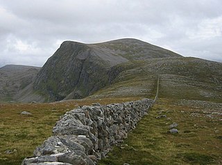
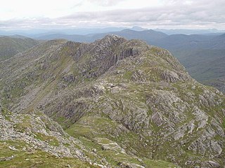
Am Faochagach as seen from Cona' Mheall
Highest point
Elevation 953 m (3,127 ft) [1]
Prominence 367 m (1,204 ft)
Listing Munro, Marilyn
Geography
Location Wester Ross, Scotland
Parent range Northwest Highlands
OS grid NH303793
Topo map OS Landranger 20

Am Faochagach (953 m) is a mountain in the Northwest Highlands of Scotland. It is located in Wester Ross, north of the main road to Ullapool.

The Northwest Highlands are located in the northern third of Scotland that is separated from the Grampian Mountains by the Great Glen. The region comprises Wester Ross, Assynt, Sutherland and part of Caithness. The Caledonian Canal, which extends from Loch Linnhe in the south-west, via Loch Ness to the Moray Firth in the north-east splits this area from the rest of the country. The city of Inverness and the town of Fort William serve as gateways to the region from the south.

Wester Ross loosely defined area in the North West Highlands of Scotland

Wester Ross is an area of the Northwest Highlands of Scotland in the council area of Highland. The area is loosely defined, and has never been used as a formal administrative region in its own right, but is generally regarded as lying to the west of the main watershed of Ross, thus forming the western half of the county of Ross and Cromarty. The southwesternmost part of Ross and Cromarty, Lochalsh, is not considered part of Wester Ross by the local tourist organisation, Visit Wester Ross, but is included within the definition used for the Wester Ross Biosphere Reserve.

Ullapool village in Highland, Scotland

Ullapool is a village of around 1,500 inhabitants in Ross and Cromarty, Scottish Highlands, located around 45 miles (72 km) north-west of Inverness. Despite its small size it is the largest settlement for many miles around, and an important port and tourist destination. The North Atlantic Drift passes Ullapool, moderating the temperature. A few Cordyline australis are grown in the town and are often mistaken for palm trees.

A rounded peak, it is surrounded by moorland and bogs, and a river crossing, which makes the approach to the mountain difficult from the road. However, the ascent itself is simpler. [2]

Related Research Articles

Sgùrr Mòr (Fannichs) Mountain in Northern Scotland

Sgùrr Mòr is the highest of the nine Munros in the mountain range known as the Fannichs in northern Scotland. This range is located between Loch Fannich and the A835 Ullapool road — a remote area with few habitations, but these Munros, which are usually climbed in groups or occasionally in a single hike, are mostly gentle sloped and fairly accessible from either of these locations. If approached from Loch Fannich, a bicycle or permission to drive on the private road would be helpful.

Beinn Dearg (Ullapool) 1084m high mountain in Scotland

Beinn Dearg is a mountain in the Inverlael area of the Highlands of Scotland. It is most frequently climbed by following the River Lael up Gleann na Sguaib. Starting from near the head of Loch Broom, a path follows the glen to a bealach, which is about a kilometre north of the summit. From this bealach, the neighbouring peaks of Con a' Mheall and Meall na Ceapraichean may also be climbed. Eididh nan Clach Geala, which lies about 3 km north of Beinn Dearg, is also added in to complete a round of 4 Munros.

Sgùrr a Choire Ghlais 1083m high mountain in Scotland

Sgurr a' Choire Ghlais is a mountain in the North-west Highlands of Scotland. It lies between Glen Strathfarrar and Glen Orrin and it is an excellent viewpoint, being the highest mountain in its group - a group which includes the Munros of Sgurr na Ruaidhe, Sgurr Fhuar-thuill and Carn nan Gobhar. Northwards there is no higher ground apart from the Fannaichs.

Gleouraich 1035m high mountain in Scotland

Gleouraich is a Scottish mountain located to the north of Loch Quoich in the north western highlands. It has a height of 1035 m (3396 ft) and is classed as a Munro. The mountain's main aspects contrast with each other; the south side of the mountain is a gentle, grassy slope, but its north face is steep, dark rock, with a complex array of ridges and corries.

Sgùrr a Mhaoraich 1027m high mountain in Scotland

Sgùrr a' Mhaoraich is a Scottish mountain located to the north of Loch Quoich in the north western highlands. It has a height of 1027 m (3369 ft) and is classed as a Munro. Viewed from Kinloch Hourn to the west, or from the north, it shows large, steep, rocky flanks with a complex series of ridges and corries, but like its neighbours such as Gleouraich, its southern side is gentler and grassier.

Beinn a Bhùird Munro in the Cairngorm mountain range of Scotland

Beinn a' Bhùird is a Munro in the Cairngorm mountain range of Scotland.

Beinn Bhrotain Scottish mountain in the Cairngorms

Beinn Bhrotain or Ben Vrottan is a Scottish mountain in the Cairngorms range, 18 kilometres west of Braemar in the county of Aberdeenshire.

Monadh Mòr Scottish mountain

Monadh Mòr is a mountain in the Cairngorms region of the Highlands of Scotland.

Aonach Buidhe

Aonach Buidhe is a remote mountain in the Northwest Highlands of Ross and Cromarty in northwest Scotland. The nearest village is Dornie.

A Ghlas-bheinn

A' Ghlas-bhienn is a mountain in the Northwest Highlands of Scotland. It lies in the Kintail area of Ross-shire, close to the settlement of Morvich.

Aonach air Chrith Mountain in Scotland

Aonach air Chrith is a mountain in the Northwest Highlands, Scotland. It is located on the southern side of Glen Shiel in Kintail.

Ruadh-stac Beag Mountain in Scotland

Ruadh-stac Beag is a mountain in the Northwest Highlands of Scotland. An outlier of the Munro Beinn Eighe but a mountain in its own right, it is located in the Torridon Hills of Wester Ross.

Bac an Eich

Bac an Eich is a mountain in Ross and Cromarty in the Northwest Highlands of Scotland.

A Chailleach (Fannaichs)

A' Chailleach is a mountain in the Northwest Highlands of Scotland. It lies in the Fannaichs of Wester Ross.

Garbh Chioch Mhòr

Garbh Chioch Mhor is a mountain in the Northwest Highlands of Scotland. It lies in the Lochaber region, between Loch Nevis and Loch Quoich.

Sgurr nan Coireachan (Glen Dessarry)

Sgurr nan Coireachan is a mountain in the Northwest Highlands of Scotland. It lies in the Lochaber region, near the head of the remote Glen Dessarry.

Aonach Shasuinn Mountain in the Northwest Highlands

Aonach Shasuinn is a mountain in the Northwest Highlands of Scotland. It lies in Inverness-shire, on the southern side of Glen Affric.

Sgurr a Gharaidh Mountain in Scotland

Sgurr a' Gharaidh is a mountain in the Northwest Highlands of Scotland. It lies in Wester Ross, north of Loch Carron.

Beinn nan Eun

Beinn nan Eun is a mountain in the Northwest Highlands of Scotland. It is located in Easter Ross, several miles northwest of Dingwall.

Creag Dhubh (Newtonmore)

Creag Dhubh is a mountain in the Grampian Mountains of Scotland. It is located in the Strathspey area of the central Highlands, above the village of Newtonmore.

References

  1. "Am Faochagach". hill-bagging.co.uk. Retrieved 21 May 2019.
  2. "walkhighlands Am Faochagach". walkhighlands.co.uk. Retrieved 21 May 2019.

Coordinates: 57°46′21″N04°51′14″W / 57.77250°N 4.85389°W / 57.77250; -4.85389

Geographic coordinate system Coordinate system

A geographic coordinate system is a coordinate system that enables every location on Earth to be specified by a set of numbers, letters or symbols. The coordinates are often chosen such that one of the numbers represents a vertical position and two or three of the numbers represent a horizontal position; alternatively, a geographic position may be expressed in a combined three-dimensional Cartesian vector. A common choice of coordinates is latitude, longitude and elevation. To specify a location on a plane requires a map projection.