The Ying Tung Natatorium is a swimming venue located in the Olympic Sports Centre in Beijing, China with a seating capacity of 4,852. It was upgraded for the 2008 Summer Olympics and expanded to 44,635 square metres. It hosted Olympic water polo matches and the swimming part of the modern pentathlon event. The renovations were complete by September 10, 2007.

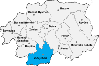
Senné is a village and municipality in the Veľký Krtíš District of the Banská Bystrica Region of southern Slovakia.

Bonner Platz is an U-Bahn station in Munich on the U3.

The Hermel District is a district in the Baalbek-Hermel Governorate of Lebanon. Its population is estimated at 48,000 inhabitants, with its semi-arid land contributing to its low population density. It borders the Akkar District and Miniyeh-Danniyeh District on its west, the Baalbek District in the south and east, and Syria on its north.

Erle is a former settlement in Yuba County, California. It was located 6.25 miles (10.1 km) north-northeast of Wheatland, at an elevation of 115 feet. Erle still appeared on maps as of 1910; the former settlement is now part of Beale Air Force Base.

Getik is a town in the Vayots Dzor Province of Armenia.
Təzəkənd or Taza-Kend may refer to:

Sultan is a village in the Lachin Rayon of Azerbaijan.

Seyidlar is a village in the Lachin Rayon of Azerbaijan.

Qədimkənd is a village and municipality in the Neftchala Rayon of Azerbaijan. It has a population of 2,320. The municipality consists of the villages of Qədimkənd and Birinci Qaralı.

Sofikənd is a village in the Quba Rayon of Azerbaijan. The village forms part of the municipality of Qamqam.

Aydınkənd is a village in the Quba Rayon of Azerbaijan. The village forms part of the municipality of Güləzi.

Mirzəqasım is a village in the Quba Rayon of Azerbaijan. The village forms part of the municipality of Hacıqaib.

Qişlaq is a village in the Khojali Rayon of Azerbaijan. The residents of the de-facto Republic of Artsakh refer to the village as Tsaghkashat, and refer to the region as Askeran.

Nuraly-Kend is a village in the Sabirabad Rayon of Azerbaijan.

Janów is a village in the administrative district of Gmina Biała Rawska, within Rawa County, Łódź Voivodeship, in central Poland. It lies approximately 8 kilometres (5 mi) south-east of Biała Rawska, 23 km (14 mi) east of Rawa Mazowiecka, and 77 km (48 mi) east of the regional capital Łódź.

Fairgrange is an unincorporated community in Seven Hickory Township, Coles County, Illinois, United States.

Wielowieś is a village in the administrative district of Gmina Sulęcin, within Sulęcin County, Lubusz Voivodeship, in western Poland. It lies approximately 18 kilometres (11 mi) east of Sulęcin, 39 km (24 mi) south of Gorzów Wielkopolski, and 52 km (32 mi) north of Zielona Góra.
Metsküla is a village in Märjamaa Parish, Rapla County in western Estonia.

Cassils is a hamlet in southern Alberta, Canada within the County of Newell. It is located on the north side of a Canadian Pacific rail line 2.9 km (1.8 mi) west of the intersection of Highway 36 and Highway 542. It is 10 km (6.2 mi) west of the City of Brooks and 7.5 km (4.7 mi) south of the Trans-Canada Highway.


