Armenia is a landlocked country in the South Caucasus region of the Caucasus. The country is geographically located in West Asia, within the Armenian plateau. Armenia is bordered on the north and east by Georgia and Azerbaijan and on the south and west by Iran, Azerbaijan's exclave Nakhchivan, and Turkey.
The Hari River or Herat River or Tejen River or Harirud is a river flowing 1,100 kilometres (680 mi) from the mountains of central Afghanistan to Turkmenistan, where it forms the Tejen oasis and disappears in the Karakum Desert. In its lower course, the river forms a northern part of the border between Afghanistan and Iran, and a southeastern part of the border between Turkmenistan and Iran.

Neftchala District is one of the 66 districts of Azerbaijan. It is located in the southeast of the country and belongs to the Shirvan-Salyan Economic Region. The district borders the districts of Jalilabad, Bilasuvar, Salyan, Lankaran, and Masally. Its capital and largest city is Neftchala. As of 2020, the district had a population of 88,900.
Batken is a town in southwestern Kyrgyzstan, on the southern fringe of the Fergana Valley. It is the administrative seat of Batken Region. Since 2000, it is a city of regional significance, i.e. not part of a district. However, it is still the administrative seat of Batken District. Its area is 205 square kilometres (79 sq mi), and its resident population was 27,730 in 2021. The population of the town proper was 15,805.

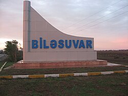
Bilasuvar District is one of the 66 districts of Azerbaijan. It is located in the south-east of the country, in the Shirvan-Salyan Economic Region. The district borders the districts of Imishli, Saatly, Sabirabad, Salyan, Neftchala, Jalilabad, and Ardabil Province of Iran. Its capital and largest city is Bilasuvar. As of 2020, the district had a population of 105,100.

Imishli District is one of the 66 districts of Azerbaijan. It is located in the centre of the country and belongs to the Central Aran Economic Region. The district borders the districts of Beylagan, Zardab, Kurdamir, Sabirabad, Saatly, Bilasuvar, and the Ardabil Province of Iran. Its capital and largest city is Imishli. As of 2020, the district had a population of 158,682.

Saatly District is one of the 66 districts of Azerbaijan. It is located in the centre of the country, belonging to the Central Aran Economic Region. The district borders the districts of Imishli, Sabirabad, and Bilasuvar. Its capital and largest city is Saatly. As of 2020, the district had a population of 109,100.

Salyan District is one of the 66 districts of Azerbaijan. Located in the east of the country, it belongs to the Shirvan-Salyan Economic Region. The district borders the districts of Bilasuvar, Sabirabad, Hajigabul, Baku, Neftchala, and the city of Shirvan. Its capital and largest city is Salyan. As of 2020, the district had a population of 139,900.

Oğuz is a city, municipality and the capital of the Oghuz District of Azerbaijan. The village was populated by Armenians and Udis before the exodus of Armenians from Azerbaijan after the outbreak of the Nagorno-Karabakh conflict.

Lerik is the capital city of Lerik District in the southern area of Azerbaijan not far from the Iran border. It is located in the Talysh Mountains, a northwestern subrange of the Alborz (Elburz) mountain range. The majority of the population is Talysh.

Beylagan is the administrative centre of the Beylagan District of Azerbaijan. During the Soviet era, it was renamed Zhdanovsk after Stalinist politician Andrei Zhdanov. After the collapse of the Soviet Union, the city reverted in 1991 to its original name. Beylagan is one of the oldest towns in Azerbaijan. It is located in the triangle between the Kura and Aras rivers in the Mil plain.

The Absheron Peninsula is a peninsula in Azerbaijan. It is the location of Baku, the biggest and the most populous city of the country, and also the Baku metropolitan area, with its satellite cities Sumqayit and Khyrdalan.
Tazakend or T’azak’end may refer to:
Təzəkənd or Taza-Kend may refer to:

Imishli is a city and the capital of the Imishli District of Azerbaijan.
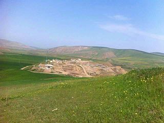
Yeddioymaq is a village in the Bilasuvar Rayon of Azerbaijan.
Kazakhbarasi is a village in the Jalilabad Rayon of Azerbaijan. Kazakhbarasi is a small village located in Azerbaijan, situated approximately 90 km north of Lencoran and 200 km from the capital city. The village is located about 110 km southeast of the Azerbaijan-Iran border. According to the latest census, the population of Kazakhbarasi is around 150 people.
Biləsuvar is a village in the Bilasuvar Rayon of Azerbaijan.
Beybaghli is a village in Gowg Tappeh Rural District, in the Central District of Bileh Savar County, Ardabil Province, Iran. The village is located between two cities of Germi and Bilasuvar north of Ardabil, on the Iranian Azerbaijan and the Republic of Azerbaijan border. Beybagli is home to Beybagli tribe, one of the 32 tribes of the Turkish Shahseven tribal confederacy of Mughan. The people of this village are engaged in traditional farming and herding practices. Wheat, barley, lentils, and peas are grown. The village's dairy products are milk, cheese, butter, cream and yoghurt. At the 2006 census, its population was 19, in 7 families.
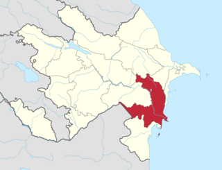
Shirvan-Salyan Economic Region is one of the 14 economic regions of Azerbaijan. It borders Iran to the west, as well as the economic regions of Mil-Mughan, Central Aran, Mountainous Shirvan, Absheron-Khizi, Baku, and Lankaran-Astara. The region consists of the districts of Bilasuvar, Hajigabul, Neftchala, Salyan, as well as the city of Shirvan. It has an area of 6,080 square kilometres (2,350 sq mi). Its population was estimated to be at 501.3 thousand people in January 2021.