Amaravati is the capital of the Indian state of Andhra Pradesh.
Contents
Amaravati, Amaravathi or Amravati may also refer to:
Amaravati is the capital of the Indian state of Andhra Pradesh.
Amaravati, Amaravathi or Amravati may also refer to:

Coastal Andhra, also known as Kosta Andhra, is a geographic region in the Indian state of Andhra Pradesh, comprising the coastal districts of the state between the Eastern Ghats and the Bay of Bengal, from the northern border with Orissa to Rayalaseema in the south. It includes major cities such as Visakhapatnam and Vijayawada as well as the state capital Amaravati and is recognized for its fertile lands, rich cultural heritage, and economic importance. Coastal Andhra plays a significant role in the state's agricultural output, particularly in rice and tobacco production, supported by abundant water resources from the Godavari, Krishna, and Penna rivers.

The Amaravati River is the longest tributary of the Kaveri River in the fertile districts of Udumalpet, Dharapuram and Karur Tamil Nadu state, South India.
Kota or KOTA may refer to:

The Satavahanas, also referred to as the Andhras in the Puranas, were an ancient Indian dynasty. Most modern scholars believe that the Satavahana rule began in the late second century BCE and lasted until the early third century CE, although some assign the beginning of their rule to as early as the 3rd century BCE based on the Puranas, but uncorroborated by archaeological evidence. The Satavahana kingdom mainly comprised the present-day Andhra Pradesh, Telangana, and Maharashtra. At different times, their rule extended to parts of modern Gujarat, Madhya Pradesh, and Karnataka. The dynasty had different capital cities at different times, including Kotalingala (Telangana), Pratishthana (Paithan) and Amaravati (Dharanikota).

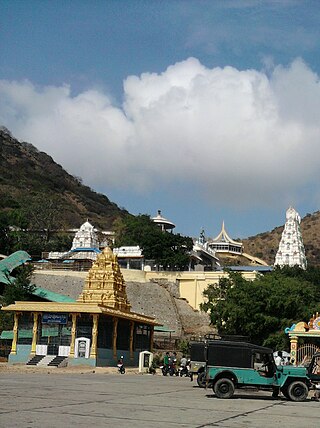
Amaravathi is a village located on the banks of the Krishna River in the Guntur district of Andhra Pradesh, India. It serves as the administrative centre of Amaravathi mandal and is part of the Andhra Pradesh Capital Region. The state's newly planned capital city, Amaravati, located 35 km (22 mi) to the east, derives its name from this historic village.

Guntur district is one of the twenty six districts in the Coastal Andhra region of the Indian state of Andhra Pradesh. The administrative seat of the district is located at Guntur, the largest city of the district in terms of area and with a population of 670,073. It has a coastline of approximately 100 km (62 mi) on the right bank of Krishna River, that separates it from Krishna district and NTR district. It is bounded on the south by Bapatla district and on the west by Palnadu district. It has an area of 2,443 km2 (943 sq mi), with a population of 20,91,075, as per 2011 census of India.

Dharanikota is a village in Palnadu district of the Indian state of Andhra Pradesh. It is located in Amaravathi mandal of Sattenapalli revenue division. The village forms a part of Andhra Pradesh Capital Region, under the jurisdiction of APCRDA.

Nagarjunakonda: Nāgārjunikoṇḍa, meaning Nagarjuna Hill) is a historical town, now an island located near Nagarjuna Sagar in Palnadu district of the Indian state of Andhra Pradesh. It is one of India's richest Buddhist sites, and now lies almost entirely under the lake created by the Nagarjuna Sagar Dam. With the construction of the dam, the archaeological relics at Nagarjunakonda were submerged, and had to be excavated and transferred to higher land, which has become an island.

The Amaravathi Dam is a dam constructed across the Amaravathi River. It is located at Amaravathinagar, 25 kilometres (16 mi) south of Udumalpet on SH 17 in the Indira Gandhi Wildlife Sanctuary, Tirupur district in the Indian state of Tamil Nadu. The associated Amaravathi Reservoir is 9.31 square kilometres (3.59 sq mi) in area and 33.53 metres (110.0 ft) deep. The dam was built primarily for irrigation and flood control and now also has four megawatts of electrical generating capacity installed. It is notable for the significant population of mugger crocodiles living in its reservoir and catchment basin.
Malladi is a village in Palnadu district of the Indian state of Andhra Pradesh. It is located in Amaravathi mandal of Sattenapalli revenue division. The village forms a part of Andhra Pradesh Capital Region, under the jurisdiction of APCRDA.

The Emblem of Andhra Pradesh serves as the official state emblem of the Indian state of Andhra Pradesh.

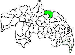
Amaravathi mandal is one of the 28 mandals in Palnadu district of the Indian state of Andhra Pradesh. It is under the administration of Sattenapalli revenue division and the headquarters are located at Amaravathi. The mandal is located on the banks of Krishna River, at a distance 27 km from the district headquarters. It is bounded by Atchampet, Krosuru, Pedakurapadu, Tadikonda and Thullur mandals.

Thullur mandal is one of the 18 mandals in Guntur district of the Indian state of Andhra Pradesh. It is under the administration of Guntur Revenue Division and the headquarters are located at Thullur. The mandal is situated on the banks of Krishna River, bounded by Amaravathi, Tadikonda, Tadepalle and Mangalagiri mandals. The mandal is also a part of the new capital city of Andhra Pradesh to be developed. 18 villages from the mandal fall under the jurisdiction of Andhra Pradesh Capital City.

Amaravati is the capital city of the Indian state of Andhra Pradesh. It is situated in Guntur district along the right bank of the Krishna River and southwest of Vijayawada. The city is named after the nearby historic site of Amaravathi adjacent to Dharanikota, which was once the capital of the Satavahana dynasty around two millennia ago. Amaravati is part of the Andhra Pradesh Capital Region, which includes the neighboring cities of Vijayawada and Guntur.

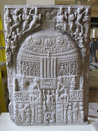
Amarāvati Stupa is a ruined Buddhist stūpa at the village of Amaravathi, Palnadu district, Andhra Pradesh, India, probably built in phases between the third century BCE and about 250 CE. It was enlarged and new sculptures replaced the earlier ones, beginning in about 50 CE. The site is under the protection of the Archaeological Survey of India, and includes the stūpa itself and the Archaeological Museum.

Vykuntapuram, also spelled as Vaikuntapuram, is a village in Guntur district of the Indian state of Andhra Pradesh. It is located in Amaravathi mandal of Guntur revenue division. The village forms a part of Andhra Pradesh Capital Region, under the jurisdiction of APCRDA.

Narukullapadu is a village in Palnadu district of the Indian state of Andhra Pradesh. It is located in Amaravathi mandal of Guntur revenue division. Kondaveeti Vagu river flows through the village, which frequently floods causing significant damage to crops and risking lives. The village forms a part of Andhra Pradesh Capital Region, under the jurisdiction of APCRDA.
Nekkallu is a neighbourhood and a part of Urban Notified Area of Amaravati, the state capital of the Indian state of Andhra Pradesh. It was a village in Thullur mandal of in Guntur district, prior to its denotification as gram panchayat.

Palnadu district is a district in coastal Andhra Region in the Indian state of Andhra Pradesh. With Narasaraopet as its administrative headquarters, it was formed on 4 April 2022 to become one of the resultant twenty-six districts The district was formed from Gurazala, Sattenapalli and Narasaraopet revenue divisions from Palnadu district. The district covers most of the Palnadu region.
Goli is a village in Palnadu district of the Indian state of Andhra Pradesh. It is situated on the right bank of the river Goleru, which joins the Krishna River two miles to the north. It is located in Rentachintala mandal of Palnadu district in Andhra Pradesh, India. It is situated 5 km away from sub-district headquarters Rentachintala and 120 km away from Guntur. It is 49.7 km downstream of Nagarjunakonda and 113 km upstream of Amaravathi.