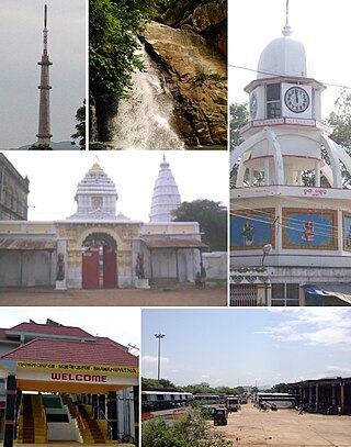
Bargarh is an emerging city and municipality in Bargarh district in the state of odisha in India. It is the administrative headquarters of Bargarh District. Bargarh is popularly known for intensive cultivation of 'paddy', therefore called "Bhata Handi" of Odisha.
Sambalpur District is a district in the western part of state of Odisha, India. The historic city of Sambalpur is the district headquarters.

Garhwa District is one of the twenty-four districts in the Indian state of Jharkhand. The Garhwa District is part of the Palamu division and has its administrative headquarters in Garhwa City.
Gajapati district is a district of Odisha State in India. It was created from Ganjam District on 2 October, 1992. Gajapati district was named after Krushna Chandra Gajapati Narayan Deb, the King of the Paralakhemundi estate and the first Prime Minister of Orissa, who is remembered for his contribution in the formation of a separate state, and inclusion of his estate in Odisha. The district headquarters at Paralakhemundi, formerly a Zamindari, has been clustered within a radius of approximately 5 kilometers around the geometric centre of Paralakhemundi. The District is a part of the Red Corridor. As of 2011 it is the third least populous district of Odisha, after Debagarh and Boudh.

Nuapada district is an area of Odisha state in India. Nuapada town is the headquarters of the district. It has one subdivision: Nuapada, and five blocks: Khariar, Sinapali, Boden, Komna, and Nuapada. Nuapada District has three Notified Area Councils: Khariar, Khariar Road, and Nuapada, six tehsils and more villages such as Gandabahali, Tukla, Hatibandha, Duajher, Bargaon, Tarbod, Udyanbandh, and Larka.

Jharsuguda is a district in Odisha, India with Jharsuguda town as its headquarters. This region is rich in coal and other mineral reserves. Of late, many small and medium scale iron and steel units have been set up in the vicinity of Jharsuguda town, giving impetus to the industrial growth of the district.
Bargarh District is an administrative district of Odisha state in eastern India. The city of Bargarh is its district headquarters. The district was carved out of the erstwhile district of Sambalpur on 1 April 1993.
Bhawanipatna is a city and the headquarter of Kalahandi district in the state of Odisha, India. Bhawanipatna has numerous temples dedicated to different deities of the Hindu pantheon. It is named after the presiding deity, Bhawani-Shankar, and Patna, which means "place" in Odia.
Barpali is a small town and a block ( Tehsil) within the Bargarh district in the state of Odisha, India. Barpali is largely famous for renowned Odia Poet Swabhaba Kabi Gangadhar Meher who was born here. However, there are several other cultural notations which have made Barpali famous nationally and internationally, like: the indigenous sambalpuri saree weaving art and the earthen pottery handicrafts (Terracotta) etc, creations from the native inhabitants of Barpali. Among others, the name Barpali also draws attention towards the past studies, wide usage and then outward expansion of preliminary versions of sanitary toilets started by foreigners here, known as 'Barpali Toilets' nearly 40 years ago.
Khaliapali is a census town in Bargarh district in the Indian state of Odisha. Famous people from Khaliapali include the Khond saint Bhima Bhoi. ACC Cement Plant is located in Khaliapali village which provides employment to most of the youths of this village. The majority of the population depend on farming, specifically rice cultivation, which forms the bulk of the area's agricultural output.
Padampur is a town and a notified area in Bargarh district in the Indian state of Odisha.

Mahasamund district is a district in Chhattisgarh state in central India. The city of Mahasamund is the district headquarters. The district is particularly famous for the historical temple town of Sirpur besides the Mahanadi river.

Malkangiri district is the southwesternmost district in the Indian state of Odisha. It has two Vidhan sabha constituencies.
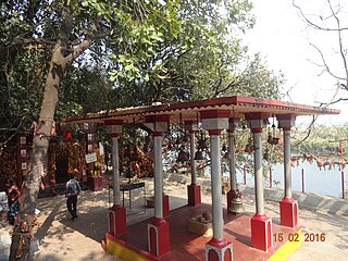
Ghess is a village in Bargarh district of western Odisha in India. Its population in 2011 was 3,342. It is known for its culture and for its role in the Indian Rebellion of 1857.
Bargarh Lok Sabha constituency is one of the 21 Lok Sabha parliamentary constituencies in Odisha state in eastern India. This constituency came into existence in 2008 as a part of the implementation of delimitation of parliamentary constituencies based on the recommendations of the Delimitation Commission of India in 2002. Before 2008, some of the constituencies were in Deogarh.
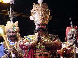
Dhanu Jatra or Dhanu Yatra is an annual drama-based open air theatrical performance celebrated in Bargarh, Odisha. Spread across a 8 km radius area around the Bargarh municipality, it is world's largest open air theater, one that finds a mention in the Guinness Book of World Records. It is based on mythological story of Krishna, and his demon uncle Kansa. Originating in Bargarh, in the present day play, the enactments of the play are being performed in many other places in Western Odisha. The major one of these is the original one at Bargarh. It is about the episode of Krishna and Balaram's visit to Mathura to witness the Dhanu ceremony organized by their (maternal) uncle Kansa. The plays start with the dethroning of emperor Ugrasena by the angry prince Kansa, over the marriage of his sister Debaki with Basudeba, and ends with death of Kansa, and Ugrasen restoring back to become the king. There is no written script used in these enactments. During this festival Kansa can punish people with penalty for their mistakes. Biju Patnaik, the former Chief Minister of Odisha was fined once along with his ministers. The department of Culture of the Government of India has accorded National Festival status to Dhanu Yatra in November 2014.
Bargarh is a Vidhan Sabha constituency of Bargarh district. Area of this constituency includes Bargarh, Bargarh block and part of Barpali block.
Jharbandh is a town in Bargarh district in the Indian state of Odisha. Jharbandh comes under the padmapur Vidhan Sabha in Odisha state and is under the Bargarh Lok Sabha constituency in India
Bhandarpuri is a village in Bargarh district in the Indian state of Odisha.
Tora is a village in Bargarh Tehsil, Bargarh District, Odisha, India. It is located in the suburb of Bargarh, about 4 kilometres southeast of the city center. In 2011, it had a population of 18,399.

