
Hambantota is the main town in Hambantota District, Southern Province, Sri Lanka. This underdeveloped area was hit hard by the 2004 Indian Ocean tsunami and is undergoing a number of major development projects including the construction of a new sea port and international airport finished in 2013. These projects and others such as Hambantota Cricket Stadium are said to form part of the government's plan to transform Hambantota into the second major urban hub of Sri Lanka, away from Colombo.

The Tissamaharama Raja Maha Vihara is an ancient Buddhist temple in Tissamaharama, Southern Province of Sri Lanka. It was one of the four major Buddhist monasteries established in Sri Lanka, after the arrival of Arhant Mahinda Thera to the country. The site of the Tissamaharama Raja Maha Vihara was consecrated by Buddha himself, who spent some time in meditation there with 500 arhats, during his third visit to the island. Tissamaharama monastery had been recognized as a pre-eminent Buddhist educational center of the southern Sri Lanka from the 3rd century B.C. to the 11th century A.D. The Tissamaharama Dagoba which is situated in the premises of the monastery is one of the largest stupas in Sri Lanka. The present chief incumbent of Tissamaharama Raja Maha Vihara is Ven. Devalegama Dhammasena Nayaka Thera.
Tangalle is a large town in Hambantota District, Southern Province, Sri Lanka, governed by an Urban Council. It is one of the largest towns in southern province. It is located 195 km (121 mi) south of Colombo and 35 km (22 mi) east of Matara. It has a mild climate, in comparison to the rest of the district, and sandy beaches.
Godavaya or Godawaya is a small fishing hamlet located at the mouth of the Walawe river, between Ambalantota and Hambantota in the Hambantota District in southern Sri Lanka.

Seruwawila Mangala Raja Maha Vihara is an ancient Buddhist temple in Trincomalee district in Eastern Province, which is among the sixteen or seventeen holiest Buddhist shrines (Solosmasthana) in Sri Lanka.
Gandara is a village in the Matara District on the southern coast of Sri Lanka, 168 kilometres (104 mi) from Colombo. It is an important village in Matara. It was slightly affected by the Asian tsunami in December 2004.

Muhudu Maha Vihara is a Buddhist temple at Pottuvil in Ampara District, Eastern province of Sri Lanka. This temple, near a wide beach, was built over 2000 years ago by King Kavan Tissa of Ruhuna. The ruins and remains of ancient stupas, Seema Malaka, Avasa Geya and statues can be seen at the site. Important ruins at the temple premises include stone statues of Buddha and two statues of old kings or gods.
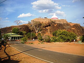
Sithulpawwa Rajamaha Viharaya is an ancient Buddhist monastery located in Hambantota District, South Eastern Sri Lanka. Situated 18 km east of the pilgrimage town Katharagama, it is believed to have been built in the 2nd century B.C by king Kavantissa. Sithulpawwa Vihara can be reached by travelling 18 miles along the Tissamaharama-Yodhakandiya road towards the Yala National Park. The name Sithulpawwa is derived from the word "Chiththala Pabbatha", which means "the hill of the quiet mind".
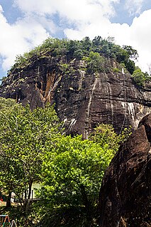
Mulkirigala Raja Maha Vihara is an ancient Buddhist temple in Mulkirigala, Sri Lanka. It has been built on a 205 m (673 ft) high natural rock, surrounded with another four rocks known as Benagala, Kondagala, Bisogala and Seelawathiegala. The temple site is located about 2 km (1.2 mi) from the Mulkirigala junction and can be reached from either Dikwella or Tangalle towns. The temple has been formally recognised by the Government as an archaeological site in Sri Lanka. The designation was declared on 8 April 1988 under the government Gazette number 501.

Magul Maha Viharaya is an ancient Buddhist temple situated in Lahugala, Ampara District of Sri Lanka. The temple lies on the northern edge of the Lahugala National Park, about 22 km off from Siyambalanduwa town and about 11 km off Pottuvil town. Lahugala has been part of the Kingdom of Ruhuna in ancient Sri Lanka. The ruins of Magul Maha Vihara are one of the major tourist attractions of the Eastern province. This temple is also an archaeologically protected monument of the country.

Naigala Rajamaha Viharaya is an ancient Buddhist temple situated in Weeraketiya, Hambantota District, Sri Lanka. It is located about 2 km (1.2 mi) away from Weeraketiya junction and 8 km (5.0 mi) from ancient Buddhist temple, Mulkirigala Raja Maha Vihara.

Aluthepola Ganekanda Raja Maha Vihara is an old Buddhist temple in Minuwangoda, Sri Lanka. According to the regional folklore this temple is believed to be one of places where King Valagamba spent his time when five Dravidian were ruling Anuradhapura. The temple has been formally recognised by the Government as an archaeological site in Sri Lanka. The designation was declared on 22 November 2002 under the government Gazette number 1264.

Maligatenna Raja Maha Vihara is an ancient Cave temple located in Malwatuhiripitiya village, Gampaha District, Sri Lanka. The temple is located on the Gampaha - Wathurugama Road and approximately 1.6 km (0.99 mi) away from the ancient temple Pilikuththuwa Raja Maha Vihara.
Delgamuwa Raja Maha Vihara is an ancient Buddhist temple situated in Kuruvita of Ratnapura District, Sri Lanka. This temple is reputed as the hiding place of the tooth relic of Buddha during the ruling period of Portuguese in the country.
Lahugala is a small town in Ampara District, Eastern Province of Sri Lanka. The town is located on Colombo-Batticaloa main road approximately 14 km (8.7 mi) away from Pothuvil town.

Dodanthale Raja Maha Vihara is an historic Buddhist temple situated in Mawanella, Kegalle District, Sri Lanka. The temple is located about 4 km (2.5 mi) away from the Mawanella town. The temple has been formally recognised by the Government as an archaeological site in Sri Lanka. The designation was declared on 10 November 1978 under the government Gazette number 10.
Asgiri Maha Viharaya is a Buddhist monastery located in Kandy, Sri Lanka. It is the headquarters of the Asgiriya chapter of Siyam Nikaya, one of the two Buddhist monasteries that holds the custodianship of sacred tooth relic of Buddha kept in Sri Dalada Maligawa, Kandy. The chief incumbent of the Asgiri Maha Viharaya is the Mahanayaka thero of Asgiri chapter of Siyam nikaya, a leading Buddhist monastic fraternity in Sri Lanka. The present chief incumbent of Asgiri Maha Viharaya is Venerable Warakagoda Sri Gnanarathana Thero. Asgiri Maha Vihara traces its origin from the Wanavasi sect of the Dimbulagala forest monastery of Polonnaruva. Currently, 565 Buddhist temples in Sri Lanka function under Asgiri Viharaya of Kandy.

Kanabiso Pokuna Raja Maha Vihara is an ancient Buddhist temple in Monaragala District, Sri Lanka. The temple is located in Handapanagala village approximately 12 km (7.5 mi) distance from Wellawaya town. The temple has been formally recognised by the Government as an archaeological site in Sri Lanka. The designation was declared on 22 November 2002 under the government Gazette number 1264.
Dodanduwa is a small coastal town situated in Galle District, Southern Province of Sri Lanka.

