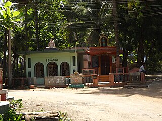
Agadallanka is a village in Eluru district in the state of Andhra Pradesh in India. The nearest train station is Gundlakamma located at a distance of 12.38 km.
Sreeparru is a village in Eluru district in the state of Andhra Pradesh in India. It is 22 km from the city of Eluru, the headquarters of Eluru district.
Mallavaram is a village in Eluru district in the state of Andhra Pradesh in India.
Bhimalapuram is a village in West Godavari district in the state of Andhra Pradesh in India. Bhimavaram railway Junction connects major towns.
Kandaravalli is a village in West Godavari district in the state of Andhra Pradesh in India. The nearest railway station is located at Palacole which is more than 10 Km from Kandaravalli.
Karugorumilli is a village in West Godavari district in the state of Andhra Pradesh in India. The nearest railway station is located in town of Palacole.

Koderu is a village in West Godavari district in the state of Andhra Pradesh in India. The nearest railway station is Palakollu (PKO) located at a distance of 3.87 Km.
Pedamallam is a village in West Godavari district in the state of Andhra Pradesh in India.

Penumanchili is a village in West Godavari district in the state of Andhra Pradesh in India.
A.I.Bheemavaram is a village in West Godavari district in the state of Andhra Pradesh in India.
Chinakapavaram is a village in West Godavari district in the state of Andhra Pradesh in India.
Dharmapuram is a village in West Godavari district in the state of Andhra Pradesh in India.
Gummuluru is a village in West Godavari district in the state of Andhra Pradesh in India. The nearest railway station is Godavari(GVN) located at a distance of 12.41 Km.
Kolleru is a village in West Godavari district in the state of Andhra Pradesh in India.
Madivada is a village in West Godavari district in the state of Andhra Pradesh in India.
Siddapuram is a village in West Godavari district in the state of Andhra Pradesh in India.
Taratava is a village in West Godavari district in the state of Andhra Pradesh in India.
Aravalli is a village in West Godavari district in the state of Andhra Pradesh in India.
Eduru is a village in West Godavari district in the state of Andhra Pradesh in India. The nearest railway station is at Krishnapatnam (KAPT) located at a distance of 15.83 Km
Gummampadu is a village in West Godavari district in the state of Andhra Pradesh in India. Relangi and Velpuru Rail Way Station are the nearest railway stations.


