The Toliara Province is a former province of Madagascar with an area of 161,405 square kilometres (62,319 sq mi). It had a population of 2,229,550. Its capital was Toliara. Near Toliara was the "spiny forest".

Fort-Dauphin, in Malagasy also used: Tolagnaro or Taolagnaro, is a city on the southeast coast of Madagascar. It is the capital of the Anosy Region and of the Taolagnaro District. It has been a port of local importance since the early 1500s. A new port, the Ehoala Port was built in 2006–2009. Fort-Dauphin was the first French settlement in Madagascar.
Tsivory is a rural commune in Anosy region in southern Madagascar. It is located at 225km from Fort Dauphin and 148 km from Amboasary Sud to which it is connected by the provincial road RIP 107. In 2018 it had a population of 18694.
Befotaka is a town in Atsimo-Atsinanana Region in south-eastern Madagascar. It is situated near the Itomampy river.
Androy is the most southerly region of Madagascar. It covers an area of 19,540 km2, and had a population of 903,376 inhabitants in 2018. The administrative capital is Ambovombe-Androy, and the chief administrator is Michael Andrianirina.
Betioky is a town in Atsimo-Andrefana Region, Madagascar and is crossed by the Route nationale 10. The population is 25,612 inhabitants in 2018.

Anosy is one of the 22 regions of Madagascar. It is located in the southeast of the country, on the eastern side of what was once the Toliara Province. The name Anosy means "island(s)" in Malagasy.
Antanimora Sud is a town and commune in Madagascar. It belongs to the district of Ambovombe-Androy, which is a part of Androy Region.
Ifotaka is a town and commune in Madagascar. It belongs to the district of Amboasary Sud, which is part of Anosy Region. The population of the commune was estimated to be approximately 21.750 in 2018.
Marotsiraka is a town and commune in Madagascar. It belongs to the district of Amboasary Sud, which is a part of Anosy Region. The population of the commune was estimated to be approximately 14,000 in 2001 commune census.
Tanandava Sud is a town and commune in Madagascar. It belongs to the district of Amboasary Sud, which is a part of Anosy Region. It has a population of 9586 inhabitants in 2018.
Mahatalaky is a rural commune in Madagascar. It belongs to the district of Taolanaro, which is a part of Anosy Region. It is situated at 35 km from Fort Dauphin. The population of the commune was estimated to be approximately 25,000 in 2001 commune census.
Tanandava may refer to one of the following locations in Madagascar:

Route nationale 7 (RN7) is a primary highway in Madagascar running 980km from the capital Antananarivo to Tulear at the south-west coast of the country. It crosses the regions of Analamanga, Vakinankaratra, Amoron'i Mania, Haute Matsiatra, Ihorombe, and Atsimo-Andrefana.
Nosifeno is a town and commune in Madagascar. It belongs to the district of Midongy-Atsimo, which is a part of Atsimo-Atsinanana Region. There are 3881 inscribed voters in this commune. It is located at the Itomampy river. From the coast and Vangaindrano it can be reached by the unpaved, secondary road T18 of 94 km in very bad state of conservation.

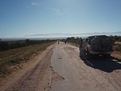
Route nationale 13 is a primary highway in Madagascar of 493 km, running from Ihosy to Tolagnaro (Fort-Dauphin). It crosses the regions of Ihorombe, Androy and Anosy.
Amboasary may refer to places in Madagascar:
The 2016 THB Champions League was the top level football competition in Madagascar. It was played from 12 August to 8 December 2016.
Amboasary Sud is a district located in Anosy Region, Madagascar. It has a population of 45,989 in 2018.

Route nationale 12a is a primary highway in Madagascar of 232 km, running from Vangaindrano to Tôlanaro. It crosses the regions of Anosy and Atsimo-Atsinanana. 10 ferries have to be taken along this road.