
Lawrenceville is an unincorporated community and census-designated place (CDP) located within Lawrence Township in Mercer County, New Jersey, United States. As of the 2010 United States Census, the CDP's population was 3,887. Lawrenceville is located roughly halfway between Princeton and Trenton.

Heide is a town in Schleswig-Holstein, Germany. It is the capital of the Kreis (district) Dithmarschen. Population: 21,000.

Bradford is a census-designated places in the town of Bradford, Orange County, Vermont, United States. The population was 907 at the 2020 census. The village disincorporated on December 1, 2004. The village became a census-designated place in 2008. The central commercial and residential portion of the village is listed on the National Register of Historic Places as the Bradford Village Historic District.

Mataiva, Tepoetiriura or Lazarev atoll is a coral atoll in the Tuamotu Archipelago. It is located in the Palliser group, and is the westernmost of the Tuamotus. The nearest atoll, Tikehau, is located 35 km to the east. Rangiroa is located 79 km to the east, and Tahiti is 311 km to the south.

Três Pontas is a municipality located in southern Minas Gerais state, Brazil. It's a city with about all streets of urban zone paved and services of water and sewage to all people. The municipality has about 57 thousand inhabitants and a population density of 78,12hab/km2. The road MG-167 is the only paved road that passes through the city, but the Rodovia Fernão Dias (BR-381), is less than 50 km from the city centre passing through Varginha.

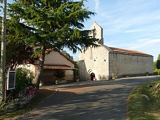
Dompierre-les-Ormes is a commune in the department of Saône-et-Loire in Bourgogne-Franche-Comté, France.

Anaa, Nganaa-nui is an atoll in the Tuamotu archipelago, in French Polynesia. It is located in the north-west of the archipelago, 350 km to the east of Tahiti. It is oval in shape, 29.5 km in length and 6.5 km wide, with a total land area of 38 km2 and a population of 504. The atoll is made up by eleven small barren islands with deeper and more fertile soil than other atolls in the Tuamotus. The lagoon is shallow, without entrance, and formed by three main basins. Although it does not have any navigable access, the water of the lagoon renews by several small channels that can be crossed walking.
Pasaband District is located in Ghor Province, Afghanistan. The population is 92,900. Located in the southern part of Ghor Province, Pasaband District borders Helmand Province to the south, Daykundi Province to the east, and Farah Province to the southwest. The district center is Shinkot.

Lunca de Sus is a commune in Harghita County, Romania. It lies in the Szekely Land, an ethno-cultural region in eastern Transylvania.
Dawlat Shah District is located approximately 74 km from Mehterlam, the provincial centre of Laghman Province in Afghanistan. It is a mountainous district and borders Nuristan Province to the North and North-East, Alingar District to the East, Alishing District to the South and Kapisa and Parwan provinces to the West. The population is 36,950 (2019) - 50% Tajik, 40% Pashai and 10% Pashtun. It has 60 villages. The district center is the village of Dawlat Shah, located on 34.9528°N 70.07°E at 1583 m altitude in the Hindukush mountains in the valley of the Alishing river. On 20 May 2021 it was captured by Taliban.

Saint-Gervais-les-Bains is a commune in the Haute-Savoie department in the Auvergne-Rhône-Alpes region, southeastern France. The village is best known for tourism and has been a popular holiday destination since the early 1900s. It has 445 km of pistes, the third largest domain exclusively in France, and is one of the least busy ski areas of its size. In 1892, two hundred people were killed when a water pocket in a glacier above the town suddenly burst open and caused flooding.
Saint-Sulpice-de-Ruffec is a commune in the Charente department in southwestern France. With 31 inhabitants (2018), it is the least populated commune of Charente.
Rociu is a commune in Argeș County, Muntenia, Romania. It is composed of four villages: Gliganu de Jos, Gliganu de Sus, Rociu and Șerbănești.
Keita is a town and commune in Niger. It is the capital of the Keita Department, within the Tahoua Region, and has a population of 10,631 as of 2012.

Ten Hamadi or Tenhemad is a village and rural commune in southern Mauritania, in the Aïoun El Atrouss department of the Hodh El Gharbi region. In 2000, the commune had a population of 2,264, of which 155 lived in the village of Ten Hamadi itself, approximately 17 kilometres (11 mi) southwest of the main town and departmental capital of Aïoun El Atrouss. The population estimate in 2007 was 3,686, spread over 16 villages.

Urussanga is a municipality in the state of Santa Catarina in the South region of Brazil. The name means "very cold water" in the Tupi language.
Garhanga is a village and rural commune in Niger. It is located in the Keita Department of the Tahoua region. As of 2012, it has a population of 69,712.

Water supply and sanitation in Burkina Faso are characterized by high access to water supply in urban areas, while access to an at least basic water sources in rural areas – where three quarters of the population live – remains relatively low. An estimated one third of water facilities in rural areas are out of service because of a lack of maintenance. Access to at least basic sanitation lags significantly behind access to water supply.
Talata Volonondry is a rural commune in Analamanga Region, in the Central Highlands of Madagascar. It belongs to the district of Antananarivo Avaradrano and its population numbers to 18,314 in 2018.
