Related Research Articles

The Strait of Juan de Fuca is a body of water about 96 miles long that is the Salish Sea's main outlet to the Pacific Ocean. The international boundary between Canada and the United States runs down the centre of the Strait.

Dall Island is an island in the Alexander Archipelago off the southeast coast of Alaska, just west of Prince of Wales Island and north of Canadian waters. Its peak elevation is 2,443 feet above sea level. Its land area is 254.0 square miles (657.9 km2), making it the 28th largest island in the United States. Dall is used economically for fishing and limestone quarrying.
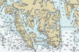
Long Island is an island in the Alexander Archipelago of southeastern Alaska, United States. It lies across the Kaigani Strait from the southern portion of Dall Island and west of the southern part of Prince of Wales Island. Directly to its north is Sukkwan Island. Long Island forms part of the western boundary of Cordova Bay, and has a land area of 116.136 km2 and was unpopulated at the 2000 census.

During the Age of Discovery, the Spanish Empire undertook several expeditions to the Pacific Northwest of North America. Spanish claims to the region date to the papal bull of 1493, and the Treaty of Tordesillas signed in 1494. In 1513, this claim was reinforced by Spanish explorer Vasco Núñez de Balboa, the first European to sight the Pacific Ocean, when he claimed all lands adjoining this ocean for the Spanish Crown. Spain only started to colonize the claimed territory north of present-day Mexico in the 18th century, when it settled the northern coast of Las Californias.

Milbanke Sound is a sound on the coast of the Canadian province of British Columbia.

Cape Muzon is a cape located in the Alexander Archipelago of the U.S. state of Alaska. It is the southernmost point of Dall Island and the headland marking the northwestern extremity of the Dixon Entrance. The boundary line separating Alaska from Canada runs very close to Cape Muzon, although according to the Alaska Boundary Treaty Cape Muzon is defined precisely as the western end of the so-called A-B Line, part of the Canada–United States border.

The maritime fur trade, a ship-based fur trade system, focused largely on acquiring furs of sea otters and other animals from the indigenous peoples of the Pacific Northwest Coast and natives of Alaska. Entrepreneurs also exploited fur-bearing skins from the wider Pacific and from the Southern Ocean.

Cordova Bay is a bay in the Alexander Archipelago of southeast Alaska. It opens onto Dixon Entrance to the south, between Cape Muzon on Dall Island and Point Marsh. The name Puerto Cordova y Cordova was given by the Spanish explorer Lieutenant Don Jacinto Caamaño in 1792, in honor of Admiral Luis de Córdova y Córdova. The name was published by George Vancouver in 1798.

Ernest Sound is a strait in Southeast Alaska, U.S.A. It extends 48 kilometres (30 mi) southwest, from the mouth of Bradfield Canal to Clarence Strait, separating Wrangell and Etolin Islands from the mainland. It was first traversed and charted in 1793 by James Johnstone, one of George Vancouver's officers during his 1791-95 expedition. Vancouver later named it "Prince Ernest's Sound", after Prince Ernest, Duke of Cumberland.

William Henry Bay is a waterway in the U.S. state of Alaska. It is located near Haines in the Alexander Archipelago. The only commercial copper deposit in Southeast Alaska situated north of Prince of Wales Island was located in the bay. Significant gold and strategic mineral anomalies were found at William Henry Bay during surveys in 2011.

Berners Bay is a waterway in the U.S. state of Alaska, approximately 40 miles (64 km) north of Juneau. It is a large and deep indentation, about 3.5 miles (5.6 km) wide at the entrance, which is formed by Point Bridget and Point St. Marys. It runs in a north-northwest direction for 6 miles (9.7 km) from Point Bridget, with a width of 3 miles (4.8 km) opposite Point St. Marys. The bay is surrounded by Tongass National Forest.

Tongass Narrows is a Y-shaped channel, part of Southeast Alaska's Inside Passage. The waterway forms part of the Alaska Marine Highway and as such, is used by charter, commercial fishing, and recreational vessels, as well as commercial freight barges and tanks, kayaks and passenger ferries. A proposal to build the Gravina Island Bridge across the Tongass Narrows was shelved due to a national-level controversy over the "bridge to nowhere".

Pennock Island is located in the U.S. state of Alaska near the city of Ketchikan. The island is situated within the Ketchikan Gateway Borough and is part of the Alexander Archipelago. Most of the island is public land managed by the Tongass National Forest.
Moira Sound is a branching inlet on the east side of the southern end of Prince of Wales Island in U.S. state of Alaska. It is situated within the Tongass National Forest.

Isanotski Strait is a strait connecting the northern Gulf of Alaska with the Bering Sea, in the U.S. state of Alaska. Isanax̂ is the Aleut name for present day Isanotski Strait, and means gap, hole, rent, or tear in the Aleut language which was rendered as Isanotski in transliterated Russian. The strait appears as Исанакъ in 1802 and Исаноцкый in 1844 on Russian maps.

Ikatan Bay is a waterway in the U.S. state of Alaska. The bay and Isanotski Strait separate Unimak Island from the Alaska Peninsula. They have been used by light-draft craft, intended for service on the Yukon River, in making the passage from Puget Sound ports to St. Michael.

Ikatan Peninsula is the southeastern extremity of Unimak Island in the U.S. state of Alaska.
Kaigani Strait is a waterway in the U.S. state of Alaska, the southern part of the strait between Long Island and Dall Island. The Alaska Native name, as reported by Etolin is 1833, is Kalgan.
Cholmondeley Sound is a deep bay or inlet on the southeast side of Prince of Wales Island, in the Alexander Archipelago of southeast Alaska, in Tongass National Forest and connecting to Clarence Strait. The sound's entrance lies between Chasina Point and Skin Island. It is about 20 miles (32 km) west of Ketchikan, Alaska. Cholmondeley Sound has several bays and inlets within it, including Kitkun Bay, Dora Bay, Brennan Bay, and Sunny Cove. At its western end Cholmondeley Sound splits into two fjord-like inlets: West Arm Chomondeley Sound, about 7.5 miles (12.1 km) long, and South Arm Cholmondeley Sound, about 8 miles (13 km) long. The full length from the entrance of the sound to the head of West Arm is about 16 miles (26 km).
Kaigani was a major trading site for maritime fur traders and the Kaigani Haida during the maritime fur trade era of approximately 1790 to 1850. The term was used for a few nearby anchorages near several Haida settlements such as Kasaan. During this time Kaigani was one of the most popular sites for trading vessels on the Pacific Northwest coast. Hundreds of trading vessels, mostly American, visited during this time, mostly seeking sea otter skins to take to China, where they commanded a high price.
References
 This article incorporates text from this source, which is in the public domain : Pacific Coast Pilot's Pacific Coast Pilot: Alaska. Dixon entrance to Yakutat Bay with inland passage from Strait of Fuca to Dixon entrance (1891)
- This article incorporates text from this source, which is in the public domain : A. R. Schultz's A Geologic Reconnaissance for Phosphate and Coal in Southeastern Idaho and Western Wyoming (1918)
- ↑ Baker 1902, p. 73.
- ↑ Pacific Coast Pilot 1891, p. 83.
- 1 2 3 Hilson, Stephen E. (1997). Exploring Alaska & British Columbia: Skagway to Barkley Sound. Evergreen Pacific Publishing. pp. 56–57. ISBN 094526559X.
- 1 2 Gibson, James R. (1999). Otter Skins, Boston Ships and China Goods: The Maritime Fur Trade of the Northwest Coast, 1785–1841. McGill-Queen's Press – MQUP. pp. 206–207. ISBN 978-0-7735-2028-8 . Retrieved 14 June 2019.
- ↑ Gibson, p. 127
- ↑ U.S. Geological Survey Geographic Names Information System: Datzkoo Harbor
- ↑ Schultz 1918, p. 91.