The Haida are an Indigenous group who have traditionally occupied Haida Gwaii, an archipelago just off the coast of British Columbia, Canada, for at least 12,500 years.
Hydaburg is a first-class city in the Prince of Wales-Hyder Census Area, in the U.S. state of Alaska. The population was 382 at the 2000 census and 376 as of the 2010 census. The name "Hydaburg" refers to the Haida people.

Kasaan is a city in the Prince of Wales-Hyder Census Area in the U.S. state of Alaska. The population was 49 at the 2010 census, up from 39 in 2000. The name "Kasaan" comes from Tlingit Kasa'aan, meaning "pretty town".

Wrangell is a borough in Alaska, United States. As of the 2020 census the population was 2,127, down from 2,369 in 2010.

Prince of Wales Island is one of the islands of the Alexander Archipelago in the Alaska Panhandle. It is the fourth-largest island in the United States and the 97th-largest island in the world.

The Alexander Archipelago is a 300-mile (480 km) long archipelago in North America lying off the southeastern coast of Alaska. It contains about 1,100 islands, the tops of submerged coastal mountains that rise steeply from the Pacific Ocean. Deep channels and fjords separate the islands and cut them off from the mainland. The islands shelter the northern part of the Inside Passage as it winds its way among them.

The Dixon Entrance is a strait about 80 kilometers (50 mi) long and wide in the Pacific Ocean at the Canada–United States border, between the U.S. state of Alaska and the province of British Columbia in Canada. The Dixon Entrance is part of the Inside Passage shipping route. It forms part of the maritime boundary between the U.S. and Canada, although the location of that boundary here is disputed.

Dall Island is an island in the Alexander Archipelago off the southeast coast of Alaska, just west of Prince of Wales Island and north of Canadian waters. Its peak elevation is 2,443 feet above sea level. Its land area is 254.0 square miles (657.9 km2), making it the 28th largest island in the United States. Dall is used economically for fishing and limestone quarrying.
Resolution was a small American schooner built in the Marquesas Islands in 1793 as a tender for the maritime fur trade ship Jefferson. Later in 1793 she became the fourth European vessel to enter the Columbia River, cruising between the river and Clayoquot Sound on Vancouver Island.

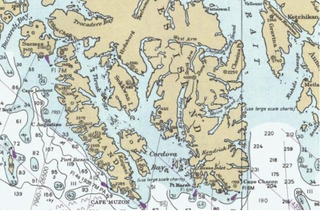
Cape Muzon is a cape located in the Alexander Archipelago of the U.S. state of Alaska. It is the southernmost point of Dall Island and the headland marking the northwestern extremity of the Dixon Entrance. The boundary line separating Alaska from Canada runs very close to Cape Muzon, although according to the Alaska Boundary Treaty Cape Muzon is defined precisely as the western end of the so-called A-B Line, part of the Canada–United States border.

The maritime fur trade, a ship-based fur trade system, focused largely on acquiring furs of sea otters and other animals from the indigenous peoples of the Pacific Northwest Coast and natives of Alaska. Entrepreneurs also exploited fur-bearing skins from the wider Pacific and from the Southern Ocean.

Cordova Bay is a bay in the Alexander Archipelago of southeast Alaska. It opens onto Dixon Entrance to the south, between Cape Muzon on Dall Island and Point Marsh. The name Puerto Cordova y Cordova was given by the Spanish explorer Lieutenant Don Jacinto Caamaño in 1792, in honor of Admiral Luis de Córdova y Córdova. The name was published by George Vancouver in 1798.
Forrester Island is an island in the U.S. state of Alaska. It is located off the coast of the Alaska Panhandle, near its southernmost portion, 20 miles (32 km) west of Dall Island, in the Prince of Wales-Hyder Census Area. The island is 5.2 miles (8.4 km) long and covers an area of 3.97 sq mi (10.29 km2). It is wooded and mountainous, rising 814 feet (248 m) in elevation.
Kaigani Strait is a waterway in the U.S. state of Alaska, the southern part of the strait between Long Island and Dall Island. The Alaska Native name, as reported by Etolin is 1833, is Kalgan.
American Bay is a waterway in the U.S. state of Alaska. It is located on the east side of Dall Island, facing Long Island across Kaigani Strait.
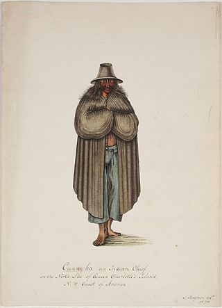
Cuneah, also Gunia, Cunneah, Cunnyha, Cunniah, Coneehaw, Connehaw, Cunneaw (Haida: Gəniyá, was the chief of Kiusta, a town at the northwestern tip of Graham Island during the era of the Maritime Fur Trade in Haida Gwaii off the North Coast of British Columbia, Canada. This town was an important port of call for acquiring sea otter skins in the early years of the maritime fur trade. Cuneah seems to have avoided the violence that plagued other Haida chiefs, like Koyah.
Cholmondeley Sound is a deep bay or inlet on the southeast side of Prince of Wales Island, in the Alexander Archipelago of southeast Alaska, in Tongass National Forest and connecting to Clarence Strait. The sound's entrance lies between Chasina Point and Skin Island. It is about 20 miles (32 km) west of Ketchikan, Alaska. Cholmondeley Sound has several bays and inlets within it, including Kitkun Bay, Dora Bay, Brennan Bay, and Sunny Cove. At its western end Cholmondeley Sound splits into two fjord-like inlets: West Arm Chomondeley Sound, about 7.5 miles (12.1 km) long, and South Arm Cholmondeley Sound, about 8 miles (13 km) long. The full length from the entrance of the sound to the head of West Arm is about 16 miles (26 km).
Cloak Bay is a bay in Haida Gwaii, British Columbia, Canada. It is located on the west side of Langara Island, between Langara and Graham Island, at the northwestern end of Haida Gwaii. It adjoins Parry Passage, the strait between Langara and Graham Island. There are several islands in Cloak Bay, the largest being Cox Island. Indian Reserves on or near Cloak Bay include Guoyskun 22, on the north side of Cloak Bay, and Kioosta 15, on Parry Passage. The historic Haida village of Kiusta is the main settlement in the area.
Kaigani was a major trading site for maritime fur traders and the Kaigani Haida during the maritime fur trade era of approximately 1790 to 1850. The term was used for a few nearby anchorages near several Haida settlements such as Kasaan. During this time Kaigani was one of the most popular sites for trading vessels on the Pacific Northwest coast. Hundreds of trading vessels, mostly American, visited during this time, mostly seeking sea otter skins to take to China, where they commanded a high price.
