
Kasaan is a city in the Prince of Wales-Hyder Census Area in the U.S. state of Alaska. The population was 49 at the 2010 census, up from 39 in 2000. The name "Kasaan" comes from Tlingit Kasa'aan, meaning "pretty town".

The Alexander Archipelago is a 300-mile (480 km) long archipelago in North America lying off the southeastern coast of Alaska. It contains about 1,100 islands, the tops of submerged coastal mountains that rise steeply from the Pacific Ocean. Deep channels and fjords separate the islands and cut them off from the mainland. The islands shelter the northern part of the Inside Passage as it winds its way among them.

The Dixon Entrance is a strait about 80 kilometers (50 mi) long and wide in the Pacific Ocean at the Canada–United States border, between the U.S. state of Alaska and the province of British Columbia in Canada. The Dixon Entrance is part of the Inside Passage shipping route. It forms part of the maritime boundary between the U.S. and Canada, although the location of that boundary here is disputed.

Dall Island is an island in the Alexander Archipelago off the southeast coast of Alaska, just west of Prince of Wales Island and north of Canadian waters. Its peak elevation is 2,443 feet above sea level. Its land area is 254.0 square miles (657.9 km2), making it the 28th largest island in the United States. Dall is used economically for fishing and limestone quarrying.
Long Island is an island in the Alexander Archipelago of southeastern Alaska, United States. It lies across the Kaigani Strait from the southern portion of Dall Island and west of the southern part of Prince of Wales Island. Directly to its north is Sukkwan Island. Long Island forms part of the western boundary of Cordova Bay, and has a land area of 116.136 km2 and was unpopulated at the 2000 census.

Cape Muzon is a cape located in the Alexander Archipelago of the U.S. state of Alaska. It is the southernmost point of Dall Island and the headland marking the northwestern extremity of the Dixon Entrance. The boundary line separating Alaska from Canada runs very close to Cape Muzon, although according to the Alaska Boundary Treaty Cape Muzon is defined precisely as the western end of the so-called A-B Line, part of the Canada–United States border.

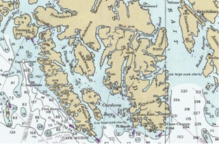
Cordova Bay is a bay in the Alexander Archipelago of southeast Alaska. It opens onto Dixon Entrance to the south, between Cape Muzon on Dall Island and Point Marsh. The name Puerto Cordova y Cordova was given by the Spanish explorer Lieutenant Don Jacinto Caamaño in 1792, in honor of Admiral Luis de Córdova y Córdova. The name was published by George Vancouver in 1798.
Aaron Island is an island in the City and Borough of Juneau, Alaska, United States. It was named by Lester A. Beardslee in 1880. Located in Lynn Canal, it is 1.2 miles (1.9 km) northwest of Point Stephens and 17 miles (27 km) northwest of the city of Juneau.

Ernest Sound is a strait in Southeast Alaska, U.S.A. It extends 48 kilometres (30 mi) southwest, from the mouth of Bradfield Canal to Clarence Strait, separating Wrangell and Etolin Islands from the mainland. It was first traversed and charted in 1793 by James Johnstone, one of George Vancouver's officers during his 1791-95 expedition. Vancouver later named it "Prince Ernest's Sound", after Prince Ernest, Duke of Cumberland.
Brownson Island is located on the west side of Ernest Sound in the U.S. state of Alaska. Situated within the Alexander Archipelago, the island is 7 miles (11 km) above Onslow Point. It is 7 miles (11 km) long, 1–2 miles (1.6–3.2 km) wide and about 1,000 feet (300 m) in elevation. It is separated from Etolin Island by the narrow Canoe Passage, which is navigable only for boats. A number of small islands are southward of Brownson Island. Several rocks are viewable at low water south of the southern end of Brownson Island.
Union Bay is located in the Alexander Archipelago within the U.S. state of Alaska. It is situated on the northeast side of Lemesurier Point, the south point at the entrance to Ernest Sound. It is 3.5 miles (5.6 km) wide at the entrance, 1.25 miles (2.01 km) at its head, and is about 3 miles (4.8 km) long. At its head is a large lagoon, mostly bare at low water, into which empties a large stream. The waters of the bay are deep, but there is anchorage with good protection from southward, on the east side of the head of the bay, in about 18 fathoms. There is a rock with a depth of 18 feet (5.5 m) in the middle of the bay's entrance and 2.5 miles (4.0 km) northward of Lemly Rock.
Vixen Inlet is located within the U.S. state of Alaska. It is situated 6.5 miles (10.5 km) north-northeast of Lemesurier Point, the south point at the entrance to Ernest Sound. The inlet has a small islet—Sunshine Island—in the middle of its entrance, and a stream at its head. A reef is southward from the south side of Vixen Point. A reef, unmarked by kelp, lies in the middle of the entrance, about 1 mile (1.6 km) west-southwestward of Sunshine Island. There is deep water between it and the shore southward. A rock on each side near the entrance, and a rock inside of Sunshine Island, are recorded.
Hunter Bay is a waterway by Prince Edward Island, part of the Alexander Archipelago, in the U.S. state of Alaska. It is situated 2.5 miles (4.0 km) eastward of Turn Point. The entrance of the bay is about 0.75 miles (1.21 km) wide and is obstructed on its northern side by a number of islets, but the channel close around Turn Point is comparatively clear. About 1 mile (1.6 km) above the entrance, the bay contracts to a width of 825 feet (251 m), with a small grassy islet lying in the middle. The best channel is on the northern side of the islet. At approximately 0.5 miles (0.80 km) eastward of the islet is an arm making northward about 2 miles (3.2 km). The depths are shallow and the tidal currents are strong in the narrowest part. There is good anchorage in Hunter Bay. Near the south shore of the bay is an islet surrounded by a flat of considerable extent. Klinkwan is a native village on the north shore of Hunter Bay at its entrance; it has a white church with two spires. Back of the village is a prominent conical mountain, 2,400 feet (730 m) high. Klakas Inlet joins Cordova Bay westward at the entrance to Hunter Bay.
Moira Sound is a branching inlet on the east side of the southern end of Prince of Wales Island in U.S. state of Alaska. It is situated within the Tongass National Forest.

Isanotski Strait is a strait connecting the northern Gulf of Alaska with the Bering Sea, in the U.S. state of Alaska. Isanax̂ is the Aleut name for present day Isanotski Strait, and means gap, hole, rent, or tear in the Aleut language which was rendered as Isanotski in transliterated Russian. The strait appears as Исанакъ in 1802 and Исаноцкый in 1844 on Russian maps.

Ikatan Bay is a waterway in the U.S. state of Alaska. The bay and Isanotski Strait separate Unimak Island from the Alaska Peninsula. They have been used by light-draft craft, intended for service on the Yukon River, in making the passage from Puget Sound ports to St. Michael.
American Bay is a waterway in the U.S. state of Alaska. It is located on the east side of Dall Island, facing Long Island across Kaigani Strait.
Cholmondeley Sound is a deep bay or inlet on the southeast side of Prince of Wales Island, in the Alexander Archipelago of southeast Alaska, in Tongass National Forest and connecting to Clarence Strait. The sound's entrance lies between Chasina Point and Skin Island. It is about 20 miles (32 km) west of Ketchikan, Alaska. Cholmondeley Sound has several bays and inlets within it, including Kitkun Bay, Dora Bay, Brennan Bay, and Sunny Cove. At its western end Cholmondeley Sound splits into two fjord-like inlets: West Arm Chomondeley Sound, about 7.5 miles (12.1 km) long, and South Arm Cholmondeley Sound, about 8 miles (13 km) long. The full length from the entrance of the sound to the head of West Arm is about 16 miles (26 km).

Kaigani was a major trading site for maritime fur traders and the Kaigani Haida during the maritime fur trade era of approximately 1790 to 1850. The term was used for a few nearby anchorages near several Haida settlements such as Kasaan. During this time Kaigani was one of the most popular sites for trading vessels on the Pacific Northwest coast. Hundreds of trading vessels, mostly American, visited during this time, mostly seeking sea otter skins to take to China, where they commanded a high price.
