The Sioux or Oceti Sakowin are groups of Native American tribes and First Nations people from the Great Plains of North America. The Sioux have two major linguistic divisions: the Dakota and Lakota peoples. Collectively, they are the Očhéthi Šakówiŋ, or "Seven Council Fires". The term "Sioux", an exonym from a French transcription of the Ojibwe term Nadowessi, can refer to any ethnic group within the Great Sioux Nation or to any of the nation's many language dialects.

Perkins County is a county in the U.S. state of South Dakota. As of the 2020 census, the population was 2,835. Its county seat is Bison. The county was established in 1908 and organized in 1909. It was named for Sturgis, South Dakota, official Henry E. Perkins.

Buffalo County is a county in the U.S. state of South Dakota. As of the 2020 census, the population was 1,948. Its county seat is Gann Valley which, at 10 people, is the least populous county seat in the United States. The county was created in 1864, and was organized in 1871 as part of the Dakota Territory.

Mountrail County is a county in the northwestern part of North Dakota, United States. As of the 2020 census, the population was 9,809. Its county seat is Stanley. The county was originally created in 1873, then removed in 1892, annexed by Ward County. It was re-created and organized in 1909. The county is home to the headquarters of the Three Affiliated Tribes of the Mandan, Hidatsa, and Arikara people, and a large part of the county belongs to the tribe's Fort Berthold reservation.
Fort Thompson is a census-designated place (CDP) in Buffalo County, South Dakota, United States. The population was 1,282 at the 2010 census, making it the largest settlement on the Crow Creek Reservation.

The Yellowstone River is a tributary of the Missouri River, approximately 671 miles (1,080 km) long, in the Western United States. Considered the principal tributary of upper Missouri, via its own tributaries it drains an area with headwaters across the mountains and high plains of southern Montana and northern Wyoming, and stretching east from the Rocky Mountains in the vicinity of Yellowstone National Park. It flows northeast to its confluence with the Missouri River on the North Dakota side of the border, about 25 miles (40 km) west of Williston.
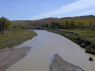
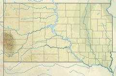
The Grand River is a tributary of the Missouri River in South Dakota in the United States. The length of the combined branch is 110 mi (177 km). With its longest fork, its length is approximately 200 mi (320 km).
The South Fork of the Grand River is a tributary of the Grand River, approximately 90 mi (145 km) long, in South Dakota in the United States.

The Moreau River a tributary of the Missouri River, approximately 200 miles (320 km) long, in South Dakota in the United States. Moreau River has the name of a pioneer trader.
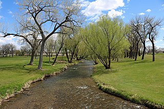
Rapid Creek is a tributary of the Cheyenne River, approximately 86 mi (138 km) long, in South Dakota in the United States. The creek's name comes from the Sioux Indians of the area, for the many rapids in the stream.
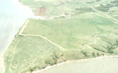
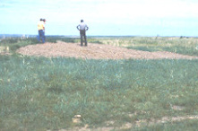
The Crow Creek massacre occurred around the mid-14th century AD and involved Native American groups at a site along the upper Missouri River in the South Dakota area; it is now within the Crow Creek Indian Reservation. Crow Creek Site, the site of the massacre near Chamberlain, is an archaeological site and a U.S. National Historic Landmark, located at coordinates 43°58′48″N 99°19′54″W. An excavation of part of the site was done in the 1950s, at the time of dam construction on the river. Additional excavations were conducted in 1978 and later.
Gann Valley is a census-designated place in and the county seat of Buffalo County, South Dakota, United States. The town had a population of 10 as of the 2020 census. It is the smallest unincorporated county seat in the United States.

The Crow Creek Indian Reservation, home to Crow Creek Sioux Tribe is located in parts of Buffalo, Hughes, and Hyde counties on the east bank of the Missouri River in central South Dakota in the United States. It has a land area of 421.658 square miles (1,092.09 km2) and a 2000 census population of 2,225 persons. The major town and capital of the federally recognized Crow Creek Sioux Tribe is Fort Thompson.

The Dakota War of 1862, also known as the Sioux Uprising, the Dakota Uprising, the Sioux Outbreak of 1862, the Dakota Conflict, or Little Crow's War, was an armed conflict between the United States and several eastern bands of Dakota collectively known as the Santee Sioux. It began on August 18, 1862, when the Dakota, who were facing starvation and displacement, attacked white settlements at the Lower Sioux Agency along the Minnesota River valley in southwest Minnesota. The war lasted for five weeks and resulted in the deaths of hundreds of settlers and the displacement of thousands more. In the aftermath, the Dakota people were exiled from their homelands, forcibly sent to reservations in the Dakotas and Nebraska, and the State of Minnesota confiscated and sold all their remaining land in the state. The war also ended with the largest mass execution in United States history with the hanging of 38 Dakota men.
The Dakota are a Native American tribe and First Nations band government in North America. They compose two of the three main subcultures of the Sioux people, and are typically divided into the Eastern Dakota and the Western Dakota.
Accokeek Creek is a tidal tributary of Potomac Creek, itself a tributary of the Potomac River, in Stafford County, Virginia, United States. From it headwaters to its mouth, Accokeek Creek is 15.4 miles (24.8 km) in total length.
Clarks Fork Creek, also called Clarks Fork or Sand Creek, is a stream in Harding County, South Dakota, United States. It is a tributary of Grand River.
White Thunder Creek is a stream in the U.S. state of South Dakota.
Crow Creek Tribal School (CCTS) is a tribal K-12 school in Stephan, South Dakota, on the Hunkpati Sioux Reservation. It is associated with the Bureau of Indian Education (BIE), and covers grades K-12. As of 2021 it had about 600 students.