
The St. Lawrence River is a large international river in the middle latitudes of North America connecting the Great Lakes to the North Atlantic Ocean. Its waters flow in a northeasterly direction from Lake Ontario to the Gulf of St. Lawrence, traversing Ontario and Quebec in Canada and New York in the United States. A section of the river demarcates the Canada–U.S. border.

The Hudson River is a 315-mile (507 km) river that flows from north to south primarily through eastern New York, United States. It originates in the Adirondack Mountains of upstate New York at Henderson Lake in the town of Newcomb, and flows southward through the Hudson Valley to the New York Harbor between New York City and Jersey City, eventually draining into the Atlantic Ocean at Upper New York Bay. The river serves as a physical boundary between the states of New Jersey and New York at its southern end. Farther north, it marks local boundaries between several New York counties. The lower half of the river is a tidal estuary, deeper than the body of water into which it flows, occupying the Hudson Fjord, an inlet that formed during the most recent period of North American glaciation, estimated at 26,000 to 13,300 years ago. Even as far north as the city of Troy, the flow of the river changes direction with the tides.

The Swan River is a major river in the southwest of Western Australia. The river runs through the metropolitan area of Perth, Western Australia's capital and largest city.
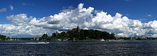
Alexandria is a town in the Thousand Islands region of the U.S. state of New York, within Jefferson County. The town's population was 3,741 at the 2020 United States Census. The town is named after Alexander LeRay, the son of an early developer. The village of Alexandria Bay is within the town.
Alexandria Bay is a village in Jefferson County, New York, United States, within the town of Alexandria. It is located in the Thousand Islands region of northern New York. The population of the village was 1,078 at the 2010 United States Census. It lies near the Thousand Islands Border Crossing of Canada and the United States.

The River Mersey is a major river in North West England. Its name derives from Old English and means "boundary river", possibly referring to its having been a border between the ancient kingdoms of Mercia and Northumbria. For centuries it has formed part of the boundary between the historic counties of Lancashire and Cheshire.
Clayton is a village in the town of Clayton in Jefferson County, New York, United States. The village population was 1,705 at the 2020 census.

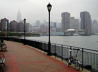
New York Harbor is at the mouth of the Hudson River where it empties into New York Bay near the East River tidal estuary, and then into the Atlantic Ocean on the East Coast of the United States.

The Verrazzano-Narrows Bridge, also referred to as the Narrows Bridge, the Verrazzano Bridge, and simply the Verrazzano, is a suspension bridge connecting the New York City boroughs of Staten Island and Brooklyn. It spans the Narrows, a body of water linking the relatively enclosed New York Harbor with Lower New York Bay and the Atlantic Ocean. It is the only fixed crossing of the Narrows. The double-deck bridge carries 13 lanes of Interstate 278: seven on the upper level and six on the lower level. The span is named for Giovanni da Verrazzano, who in 1524 was the first European explorer to enter New York Harbor and the Hudson River.

Bay Ridge is a neighborhood in the southwest corner of the New York City borough of Brooklyn. It is bounded by Sunset Park to the north, Dyker Heights to the east, the Narrows and the Belt Parkway to the west, and Fort Hamilton Army Base and the Verrazzano-Narrows Bridge to the south. The section of Bay Ridge south of 86th Street is sometimes considered part of a sub-neighborhood called Fort Hamilton.

The Narrows is the tidal strait separating the boroughs of Staten Island and Brooklyn in New York City. It connects the Upper New York Bay and Lower New York Bay and forms the principal channel by which the Hudson River empties into the Atlantic Ocean. It has long been considered to be the maritime "gateway" to New York City and historically has been one of the most important entrances into the harbors of the Port of New York and New Jersey.
Kips Bay, or Kip's Bay, is a neighborhood on the east side of the New York City borough of Manhattan. It is roughly bounded by 34th Street to the north, the East River to the east, 23rd Street to the south, and Third Avenue to the west.

Wellesley Island is an island in Jefferson County, New York, the island is partially in the Town of Orleans and partially in the Town of Alexandria.
Fishers Landing is a hamlet and census-designated place (CDP) in the town of Orleans in Jefferson County, New York, United States. It is just southwest of Grass Point State Park in the Thousand Islands region of New York. As of the 2020 census the community had a population of 119.

The Port of New York and New Jersey is the port district of the New York-Newark metropolitan area, encompassing the region within approximately a 25-mile (40 km) radius of the Statue of Liberty National Monument.
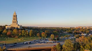
Alexandria is an independent city in the northern region of the Commonwealth of Virginia, United States. It lies on the western bank of the Potomac River approximately 7 miles (11 km) south of downtown Washington, D.C. Alexandria is the third largest "principal city" of the Washington metropolitan area which is part of the larger Washington-Baltimore combined statistical area.
Ironsides Island is an uninhabited rocky island in the Saint Lawrence River, and part of the Thousand Islands region near Alexandria Bay, New York. It is in both Jefferson and St. Lawrence counties. Most of the island lies in the town of Alexandria, in Jefferson County, while its northeasternmost corner lies in the town of Hammond, in St. Lawrence County. The island is located near Kring Point State Park.
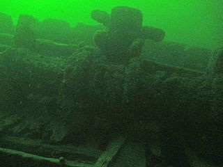
A.E. Vickery was a wooden three-masted schooner built in 1861 and measured 136.2 ft. x 26.2 ft. x 10.8 ft. The ship was launched in July 1861 at Three Mile Bay, New York, United States as J. B. Penfield, and under that name sailed through the Welland Canal on her way from Detroit, Michigan, to Oswego, New York. She was renamed A. E. Vickery on 25 February 1884 and sank on 17 August 1889 when she struck a shoal while entering the American Narrows with a cargo of 21,000 bushels of corn destined for Wisers Distillery at Prescott, Ontario, Canada. The wreck now rests at a depth of about 35 metres (115 ft) near Rock Island Light at position 44°16.820′N76°01.183′W.
The NEPCO 140 Oil Spill took place in 1976 near Clayton, New York when the NEPCO 140 ran aground while traveling inland, spilling an estimated 300,000 US gallons (1,100 m3) of oil into the Saint Lawrence River.

The Staten Island Tunnel is an abandoned, incomplete railway and subway tunnel in Staten Island,New York City. It was intended to connect railways on Staten Island to the BMT Fourth Avenue Line of the New York City Subway, in Brooklyn, via a new crossing under the Narrows. Planned to extend 10,400 feet (3,200 m), the tunnel would have been among the world's longest at the time of its planning, in the late 19th and early 20th centuries.
