
Madikeri is a hill station town in Madikeri taluk and headquarters of Kodagu district in Karnataka, India. Its original name was Muddurajanakeri which means "the city of Mudduraja".
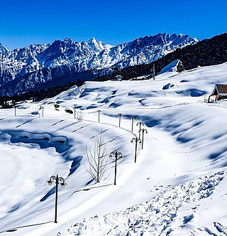
Auli is in Chamoli district in the Himalayan mountains of Uttarakhand, India. Auli, also known as Auli Bugyal, in Garhwali, which means "meadow", is located at an elevation of 2,800 metres (9,200 ft) above sea level. Between June and October, the valley has one of highest numbers of flower species found anywhere in the world, with 520 species of high-altitude plants, 498 of which are flowering plants with significant populations of endangered species.
Sironj is a town and a municipality in Vidisha district in the Indian state of Madhya Pradesh. Its also a Tehsil Headquarter.
Stody is a village and a civil parish in the English county of Norfolk. The village is 13.2 miles (21.2 km) west south west of Cromer, 21.8 miles (35.1 km) north north west of Norwich and 125 miles (201 km) north north east of London. The village lies 4.1 miles (6.6 km) south west of the town of Holt. The nearest railway station is at Sheringham for the Bittern Line which runs between Sheringham, Cromer and Norwich. The nearest airport is Norwich International Airport.

Lauria is a town and comune of the province of Potenza, in Basilicata, southern Italy, situated near the borders of Calabria. It is a walled, medieval town on the steep side of a hill, with another portion of municipal territory in the plain below.

Zangla is a village in Zanskar tehsil of Kargil district, in the Indian union territory of Ladakh. It is located 262 km (163 mi) southeast of Kargil city, the district headquarters, and 32 km (20 mi) northeast of Padum, the headquarters of Zanskar. An ancient ruined palace, known as Zangla Fort or Zangla Khar is located on a hilltop 1 km (0.62 mi) outside the village, believed to be 11th-century. The Buddhist nunnery in Zangla contains some impressive paintings.
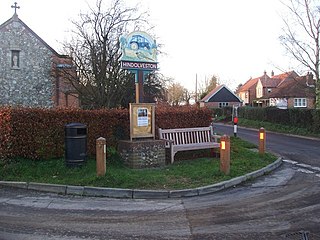
Hindolveston is a village and civil parish in the English county of Norfolk. The village is 17.5 miles (28.2 km) west-south-west of Cromer, 20.8 miles (33.5 km) north north west of Norwich and 122 miles (196 km) north east of London. The village lies 8.4 miles (13.5 km) south of the town of Holt.

Brinton is a village and a civil parish in the English county of Norfolk. The village is 10.8 miles east-north-east of the town of Fakenham, 13.1 miles west south-west of Cromer and 125 miles north-north-east of London.

Lessingham is a village and a civil parish in the English county of Norfolk. The village is 16.3 south-east of Cromer, 17.6 miles north-east of Norwich and 136 miles north-east of London. The village lies 9 miles south-east of the town of North Walsham. The nearest railway station is at Worstead for the Bittern Line which runs between Sheringham, Cromer and Norwich. The nearest airport is Norwich International Airport. The parish also includes the village of Eccles-on-Sea and the hamlet of Hempstead.

Little Snoring is a village and a civil parish in Norfolk, England.

Helhoughton is a village and civil parish in Norfolk, England. It is 4.2 miles (6.8 km) west-south-west of the town of Fakenham, 29.3 miles (47.2 km) west-northwest of Norwich and 112 miles (180 km) north-northeast of London. The nearest railway station is at Sheringham for the Bittern Line which runs between Sheringham, Cromer and Norwich. The nearest airport is Norwich International Airport. The parish had, in the 2001 census, a population of 197, rising to 346 at the 2011 Census. For the purposes of local government, the parish falls within the district of North Norfolk.

Langham is a village and a civil parish in the English county of Norfolk. The village is 14.7 miles (23.7 km) west of Cromer, 27.2 miles (43.8 km) northwest of Norwich and 126 miles (203 km) miles northeast of London. The village lies 5.2 miles (8.4 km) northwest of the town of Holt and around 2 miles (3.2 km) inland from the North Sea coast at Blakeney.

Guestwick is a village and a civil parish in the English county of Norfolk. The village is 19.6 miles (31.5 km) south-west of Cromer, 18.7 miles (30.1 km) north-west of Norwich and 131 miles (211 km) north-east of London. The village lies 10.2 miles (16.4 km) west of the nearby town of Aylsham. The village lies far from any High roads. The nearest railway station is at Sheringham for the Bittern Line which runs between Sheringham, Cromer and Norwich. The nearest airport is Norwich International Airport.
This page contains the lists of airports in Europe by country, grouped by region. The lists include both military air bases and civilian airports.
Upper Sheringham is a village and a civil parish in the English county of Norfolk. The village is 26.8 miles (43.1 km) north-north-west of Norwich, 6 miles (9.7 km) west of Cromer and 132 miles (212 km) north-north-east of London. The village is 1.2 miles (1.9 km) from the town of Sheringham.

Little Barningham is a village and a civil parish in the English county of Norfolk. The village is 19 miles (31 km) north of Norwich, 10 miles (16 km) south-west of Cromer and 133 miles (214 km) north-east of London. The nearest railway station is in the town of Sheringham where access to the national rail network can be made via the Bittern Line to Norwich. The nearest airport is Norwich International Airport. Little Barningham is within the area covered by North Norfolk District Council.

Triprangode is a village in Malappuram district in the state of Kerala, India. As of 2001 India census, Triprangode had a population of 37175 with 17422 males and 19753 females. Three sides of the village is surrounded by water bodies.

Logovardi is a village situated in Pelagonia, east of Bitola, North Macedonia.
Surat Railway Station is a major railway station serving Surat, beside Gothangam, Kosad, Utran, Udhna Junction, Bhestan, Niyol and Sachin. It is under the administrative control of the Western Railway zone of the Indian Railways. Surat is A1 – category railway station of Western Railway Zone of Indian Railways. It is on the Ahmedabad–Vadodara–Mumbai rail route. The railway station was built in 1860.
Drabshalla is a village and municipality in Kishtwar district of the Indian union territory of Jammu and Kashmir. The town is located 22 kilometres from the district headquarters Kishtwar.

