
India is the second most populated country in the world with nearly a fifth of the world's population. According to the 2019 revision of the World Population Prospects the population stood at 1,352,642,280.

Jharkhand is a state in eastern India. The state shares its border with the states of Bihar to the north, Uttar Pradesh to the northwest, Chhattisgarh to the west, Odisha to the south and West Bengal to the east. It has an area of 79,710 km2 (30,778 sq mi). It is the 15th largest state by area, and the 14th largest by population. Hindi is the official language of the state. The city of Ranchi is its capital and Dumka its sub-capital. The state is known for its waterfalls, hills and holy places; Baidyanath Dham, Parasnath and Rajrappa are major religious sites. The state was formed in 2000, from the territory that had previously been part of Bihar.
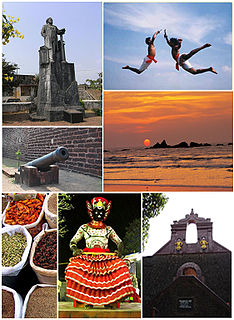
Thalassery, formerly Tellicherry, is a municipality on the Malabar Coast in Kannur district, in the state of Kerala, India, bordered by the districts of Mahé (Pondicherry), Kozhikode, Wayanad, Kasaragod and Kodagu (Karnataka). Thalassery municipality has a population just under 100,000. Thalassery Heritage City has an area of 23.98 square kilometres (9.26 sq mi). It is 22 km south of the District HQ Kannur city. Thalassery is situated in an altitude ranging from 2.5m to 30m above mean sea-level.

South Goa is one of two districts that comprises the state of Goa in India, within the region known as the Konkan. It is bounded by North Goa district to the north, the Uttara Kannada district of Karnataka state to the east and south, while the Arabian Sea forms its western coast.
Vaishali district is a district in indian state of Bihar. It is a part of Tirhut division.

Bokaro district is one of the most industrialized zones in India. It is one of the twenty-four districts of the Jharkhand state, India. It was established in 1991 by carving out one subdivision consisting of two blocks from Dhanbad District and six blocks from Giridih District.

Beed district is an administrative district in the state of Maharashtra in India. The district headquarters are located at Beed. The district occupies an area of 10,693 km² and has a population of 2,585,049 of which 17.91% were urban.

West Champaran is an administrative district in the state of Bihar in India, located just 60 km (37 mi) west of Birgunj. It is the largest district in bihar with an area of 5,228 km²(2,019sq mi). It is a part of Tirhut Division. The district headquarters are located in Bettiah. The district is known for its fluid border with Nepal. One of the major location in West Champaran is Kumar Bagh for SAIL Special Processing Unit and Bhitiharwa where Mahatma Gandhi started Satyagrah Aandolan.

Siwan district is one of the districts of Bihar state, India. Siwan town is the administrative headquarters of this district. Siwan district is a part of Saran Division since 1972. The district was previously also known as Aliganj Siwan after the name of Raja Ali Bux Khan. Siwan has historical and mythological importance attached to it. Member of Parliament from Siwan is Kavita Singh.

Gautam Buddha Nagar is a largely suburban district of Uttar Pradesh, named after Gautama Buddha. It is part of the Delhi NCR and is divided into 3 sub-divisions i.e. Noida Sadar, Dadri and Jewar. Greater Noida is the administrative headquarters of Gautam Buddha Nagar district. Noida, Greater Noida, Dadri, Jewar and Dankaur falls under this district.

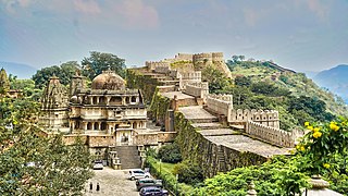
Chittaurgarh district is one of the 33 districts of Rajasthan state in western India. The historic city of Chittaurgarh is the administrative headquarters of the district. The modern district of Chittaurgarh was established on 1 August 1948 by integrating portions of various princely states: Mewar, Pratabgarh, Tonk, and Jhalawar. Chittaurgarh is famous for the Chittor fort, home to various famous Rajput dynasties.

Ambala district is one of the 22 districts of Haryana state in the country of India with Ambala town serving as the administrative headquarters of the district. District Ambala lies on the North-Eastern edge of Haryana and borders Punjab and Himachal Pradesh. Ambala District is a part of Ambala Division.

Muzaffarnagar district is a district of Uttar Pradesh state in northern India. It is part of Saharanpur division. The city of Muzaffarnagar is the district headquarters. This district is the part of National Capital Region.
Rajsamand District is a district of the state of Rajasthan in western India. The town of Rajnagar is the district headquarters. The district was constituted on 10 April 1991 from Udaipur district by carving out 7 entire tehsils - Bhim, Deogarh, Amet, Kumbhalgarh, Rajsamand, Nathdwara, and Railmagra.
Bhilwara District is a district of the state of Rajasthan in western India. The town of Bhilwara is the district headquarters.

Sirohi District is a district of Rajasthan state in western India. The town of Sirohi is the district headquarters.
The administrative divisions of India are subnational administrative units of India; they are composed of a nested hierarchy of country subdivisions.

Buxar is a nagar parishad city in the state of Bihar, India bordering eastern Uttar Pradesh. It is the headquarters of the eponymous Buxar district, as well as the headquarters of the community development block of Buxar, which also contains the census town of Sarimpur along with 132 rural villages.

Christians are an ethno-religious community residing in the Indian state of Jharkhand. As per 2011 Census of India, 4.3% of people in Jharkhand are Christians. Christians are majority in Simdega district of Jharkhand.

Meenangadi is an old town situated on the highway NH 766 between Kalpetta and Sulthan Bathery in Wayanad District, in Kerala, India. This place is one among the Provinces where the existence of Dolmens provide an historical evidence of earlier civilisation. Coffee bean, Black pepper, Ginger, Rice and Areca are the major crops cultivated in this area. Meenangadi is famous for its Fish Market and Cattle Market. The nearest railway station is at Kozhikode at 87 km and airport is Kannur International Airport with 94 km from Meenangadi. Meenangadi is surrounded by, Ambalavayal Panchayat, Kalpetta Taluk towards west, Gudalur Taluk towards East, Mananthavady Taluk towards west. Kalpetta, Sultan Bathery, Kozhikode are the nearby Cities and towns to Meenangadi.
Kerala's first carbon neutrality project launched in Meenangadi on June 2016. Upon achieving the goals of the project, Meenangadi will be the first village in India to go completely carbon neutral. Meenangadi has a population of 33450 According to 2011 Census with two Villages Purakkadi and (Part)Krishnagiri.