Related Research Articles

Pathanamthitta District, is one of the 14 districts in the Indian state of Kerala. The district headquarters is in the town of Pathanamthitta. There are four municipalities in Pathanamthitta: Adoor, Pandalam, Pathanamthitta and Thiruvalla.

Palakkad is one of the 14 districts in the Indian state of Kerala. It was carved out from the southeastern region of the former Malabar District on 1 January 1957. It is located at the centre of Kerala. It is the largest district in the state since 2006. The city of Palakkad is the district headquarters. Palakkad is bordered on the northwest by the Malappuram district, on the southwest by the Thrissur district, on the northeast by Nilgiris district, and on the east by Coimbatore district of Tamil Nadu. The district is nicknamed "The granary of Kerala". Palakkad is the gateway to Kerala due to the presence of the Palakkad Gap, in the Western Ghats. The 2,383 m high Anginda peak, which is situated in the border of Palakkad district, Nilgiris district, and Malappuram district, in Silent Valley National Park, is the highest point of elevation in Palakkad district. Palakkad city is located just 50 km away from Coimbatore, a major city in Tamil Nadu state.

Valluvanad was an independent chiefdom in present-day central Kerala that held power from the early 12th century to the end of the 18th century. Prior to that, and since the late 10th century, Valluvanad existed as an autonomous chiefdom within the kingdom of the Chera Perumals. The disintegration of the Chera Perumal kingdom in early 12th century led to the independence of the various autonomous chiefdoms of the kingdom, Valluvanad being one of them.
Feroke, is a Municipality and a part of Kozhikode metropolitan area under Kozhikode Development Authority (K.D.A) in the Kozhikode district of the Indian state of Kerala.

Peravoor is a town and Grama Panchayat in Kannur district of Kerala state in India. It is located 50 km (31 mi) east of Kannur and 40 km (25 mi) north east of Thalassery. And Iritty, the nearest municipality is 14 km (8.7 mi) north of Peravoor. Peravoor is situated in the Western Ghats mountain range.

Tanur is a coastal town, a municipality, and a block located in Tirur Taluk, Malappuram district, Kerala, India. It is located on the Malabar Coast, 9 kilometres (5.6 mi) north of Tirur and 9 kilometres south of Parappanangadi. It is the 17th-most populated municipality in the state, the fourth-most populated municipality in the district, and the second-most densely populated municipality in Malappuram district, having about 3,568 residents per square kilometre as of the year 2011. Tanur town is located south of the estuary of Poorappuzha River, which is a tributary of Kadalundi River. Tanur was one of the major ports in the southwestern coast of India during the medieval period. It was ruled by the Kingdom of Tanur, also known as Vettathunadu, who were vassals to the Zamorin of Calicut. In the early medieval period, under the chiefs of Kozhikode and Tanur, Tanur developed as one of the important maritime trade centre on the Malabar Coast. Later it became a part of Vettathunadu Taluk in Malabar District under British Raj, which was merged with the Ponnani taluk in 1860–1861. Tanur railway station is a part of the oldest Railway line of Kerala laid in 1861 from Tirur to Chaliyam. Presently, the status of Tanur is reduced to a major fishing centre in Kerala.
O' Valley or Ouchterlony Valley is a Town Panchayat in the Gudalur Taluk of The Nilgiris district in the Indian state of Tamil Nadu. The name is a contraction of an older name after a James Ouchterlony, who established coffee plantations in the area. This panchayat area is surrounded with beautiful mountains, and the waterfalls from the mountains add to the visual treat. One can enjoy by seeing cardamom, clove, pepper, tea and coffee plantations on the way to O' Valley. The place being located between Mudumalai National Park and New Amarambalam Reserved Forest, is famous for its flora and fauna. The place is surrounded by valleys, streams and water falls of which the sound is very soothing and is a mesmeric effect.

Thavanur is a village located on the southern bank of Bharathapuzha, the longest river of Kerala in the Malappuram District of Kerala state in India. This village is located at the border of Tirur and Ponnani Taluks. The Bharathappuzha River separates Thavanur from Tirunavaya and Kuttippuram towns in Tirur Taluk.

Valanchery is a major town and one of the 12 municipalities in Malappuram district, Kerala, India. It is one of the four municipalities in Tirur Taluk, besides Tirur, Kottakkal, and Tanur. It is situated about 40 kilometres (25 mi) southeast to Karipur International Airport and 25 kilometres (16 mi) southwards to the district headquarters, and forms a part of Malappuram metropolitan area. It is also one of the major commercial towns under the Malappuram urban agglomeration. Valanchery, which was a part of the erstwhile princely state of the Valluvanad in the early medieval period, had been under the direct control of the Zamorin of Calicut following the Tirunavaya war of 14th century CE. During British Raj, Valanchery was included in the Ponnani Taluk of erstwhile Malabar District. Vattapara accident zone is an accident zone near Valanchery. Valanchery is situated on National Highway 66.

Pidavoor is a village in KOLLAM district in the state of Kerala, India. Pidavoor situated near the Pathanapuram town. Pidavoor is a part of Thalavoor Grama Panchayat. It is the eighth ward of Thalavoor panchayat. It is the border of Thalavoor and Pathanapuram Panchayat. The river Kalladayar divides these two panchayats.
A tehsil is a local unit of administrative division in some countries of South Asia. It is a subdistrict of the area within a district including the designated populated place that serves as its administrative centre, with possible additional towns, and usually a number of villages. The terms in India have replaced earlier terms, such as pargana (pergunnah) and thana.

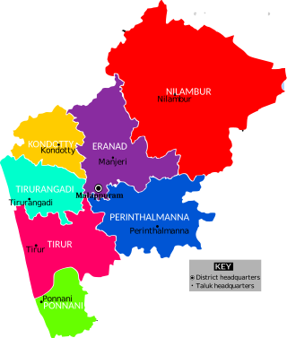
Perinthalmanna Taluk, formerly known as Walluvanad Taluk, comes under Perinthalmanna revenue division in Malappuram district of Kerala, India. Its headquarters is the town of Perinthalmanna. Perinthalmanna Taluk contains Perinthalmanna Municipality and 15 Gram panchayats. Most of the administrative offices are located in the Mini-Civil Station at Perinthalmanna.

Eranad also known as Ernad refers to the erstwhile province in the midland area of Malabar, consisting of Malappuram and nearby regions such as Anakkayam, Manjeri, Kondotty, Nilambur, etc. Currently Eranad Taluk is a Taluk in Malappuram district. Eranad was ruled by a Samanthan Nair clan known as Eradis, similar to the Vellodis of neighbouring Valluvanad and Nedungadis of Nedunganad. The rulers of Eranad were known by the title Eralppad/Eradi. They also used the title Thirumulpad.
Ponnani Taluk comes under Tirur revenue division in Malappuram district of Kerala, India. Its headquarters is the town of Ponnani. Ponnani Taluk contains Ponnani Municipality and nine gram panchayats. Most of the administrative offices are located in the Mini-Civil Station at Ponnani.
The Malappuram district has four types of administrative hierarchies:

Arimbra Hills or Mini Ooty is a tourist spot between Malappuram and Kondotty in Malappuram district, Kerala, India. It is at a height of 445 meter above sea level. The place attracts large number of visitors for its rolling hills and scenic views. The location got the nickname as it resembles Ooty, one of the famous hill stations in India. There are many stone crushers and plantations atop the hill. There is an old Harijan Colony on the western side of the hill.
Manchalloor is a village situated near Pathanapuram in Kollam District, Kerala state, India. Manchalloor is a part of Pathanapuram Grama panchayat, Block panchayat and Kollam district Panchayat.
Elections to local bodies in Kerala were held in two phrases, on 2 and 5 November 2015. The Left Democratic Front (LDF) won more than half of all gram panchayats and municipalities, and both they and the United Democratic Front (UDF) won majorities in seven out of fourteen district panchayats each. The LDF also won two corporations, the UDF won one, and the remaining three had no overall majority.
References
- 1 2 K. K. Panikkar (1974). Community development administration in Kerala. S. Chand. ISBN 9780842606448 . Retrieved 4 May 2012.
| | This article related to a location in Kerala is a stub. You can help Wikipedia by expanding it. |