An Riabhachan

Last updated

An Riabhachan
An Riabhachan.jpg
An Riabhachan seen from Sgurr na Lapaich, three kilometres to the east.
Highest point
Elevation 1,129 m (3,704 ft) [1]
Prominence 302 m (991 ft)
Listing Munro, Marilyn
Naming
English translationThe Brindled One
Language of name Gaelic
PronunciationScottish Gaelic: [əˈrˠiəvəxan]
English approximation:
ən-REER-və-khan
Geography
Scotland relief location map.jpg
Red triangle with thick white border.svg
An Riabhachan
Parent range Northwest Highlands
OS grid NH133344
Topo map OS Landranger 25, OS Explorer 414
Listed summits of An Riabhachan
NameGrid refHeightStatus
South West Top NH122336 1086 m (3563 ft)Munro Top
West Top NH117337 1040 m (3412 ft)Munro Top

An Riabhachan is a Scottish mountain in the Skye and Lochalsh district of the Highland council area. It is situated 35 kilometres east of Kyle of Lochalsh standing in an isolated position at the western end of Loch Mullardoch, ten kilometres from any public road.

Contents

Overview

An Riabhachan reaches a height of 1129 metres (3704 feet) and is one of the highest Munros north of the Great Glen. The mountain's name originates from the Gaelic language and translates as “The Brindled One” which is believed to refer to the flecked effect given by the stone studded turf on the hill. [2]

Geography

An Riabhachan is a mainly grassy mountain. The only rocky area is at the north-east end of the summit ridge, above the fine craggy coire of Coire Gnada containing the lochans of Loch Mòr and Loch Beag. The east ridge links to the adjacent Munro of Sgurr na Lapaich and follows the steep edge above Coire Gnada. The mountain has a 2.5 km long summit ridge which does not drop below 1000 metres throughout its length and contains three other high points. At the north east end of the summit ridge is the NE Top with a height of 1125 metres. In the 1921 revision of Munro's Tables it was named as the principal summit of the mountain, but reverted to the current summit in the 1933 and subsequent editions. It was deleted from the list of Munro Tops in 1997. [3]

With the demise of the NE Top, An Riabhachan has been left with just two subsidiary Tops. The West Top with a height of 1040 metres stands at the western end of the summit ridge, before descending to the Bealach Bholla and reascending to the adjoining Munro of An Socach. The South West Top lies 700m SE of the West Top and has a height of 1086 metres. [4] The summit ridge falls away on both sides over grassy slopes to Loch Mullardoch to the south and to the upper part of Glen Strathfarrar to the north.

Ascents

The mountain is usually climbed together with two or three of the other Munros on the north side of Loch Mullardoch. The most convenient ascent of all four Munros starts at the Mullardoch dam in Glen Cannich (grid reference NH219316 ) and proceeds 9 km along the loch's northern shore before climbing An Socach, continuing to An Riabhachan and returning via Sgurr na Lapaich and Càrn nan Gobhar. The long walk along the shore can be bypassed by hiring a boat, currently available between 1 April and 1 August. [5] The walk can be shortened by omitting An Socach, but it is better to include it if you can as there is no easier access to this remote Munro.

The alternative route starts in Glen Strathfarrar to the north at the hydroelectric power station in Gleann Innis (grid reference NH182381 ), reached by a 17-mile drive from Struy along a private road; the locked gate at the entrance to this road is opened at specified times to give access to vehicles. [6] From the power station a stalkers' path leads to the Bealach Toll an Lochain between An Riabhachan and Sgurr na Lapaich, from where there is a further climb west of over 300 metres to reach the summit. A return to the power station can be made over Sgurr na Lapaich and Càrn nan Gobhar.

See also

Related Research Articles

<span class="mw-page-title-main">Sgùrr Choinnich</span> Mountain in Scotland

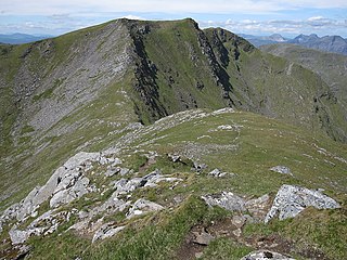
Sgùrr Choinnich is a mountain with a height of 999 metres (3,278 ft) in the Northwest Highlands of Scotland. Classed as a Munro, it is in the Achnashellach Forest area between Glen Carron and Loch Monar. It has mostly steep, grassy slopes, with a narrow summit ridge that runs east–west. There are crags on the northern side of this ridge, looking down into the corrie of Coire Choinnich.

<span class="mw-page-title-main">Càrn Eighe</span> Mountain in Scotland

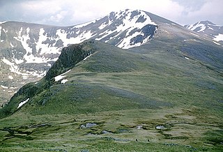
Carn Eighe is a mountain in the Northwest Highlands of Scotland. Rising to 1,183 metres (3,881 ft) above sea level, it is the highest mountain in Scotland north of the Great Glen, the twelfth-highest in the British Isles, and, in terms of relative height, it is the second-tallest mountain in the British Isles after Ben Nevis. Carn Eighe lies between Glen Affric and Loch Mullardoch, and is at the heart of a massif along with its twin peak, the 1,181-metre (3,875 ft) Mam Sodhail.

<span class="mw-page-title-main">Sgùrr na Sgine</span>

Sgùrr na Sgine is a mountain in the Northwest Highlands of Scotland. Its height is 946 metres (3,104 ft), making it a Munro. It lies eight kilometres south of Shiel Bridge in the Glenshiel Forest, between Glen Shiel and Loch Hourn.

<span class="mw-page-title-main">An Gearanach</span> Mountain in Scotland

An Gearanach is a Scottish mountain situated in the Mamore Forest, five and a half kilometres north of Kinlochleven in the Lochaber region of the Highland council area.

<span class="mw-page-title-main">Sgùrr nan Ceathramhnan</span> Mountain in the Northwest Highlands of Scotland

Sgùrr nan Ceathreamhnan is a mountain in the Northwest Highlands of Scotland. It lies between Glen Affric and Glen Elchaig, some 30 kilometres east of Kyle of Lochalsh. With a height of 1,151 metres (3,776 ft) it is classed as a Munro and ranked as the third highest mountain north of the Great Glen.

<span class="mw-page-title-main">Mam Sodhail</span> Mountain in Scotland

Mam Sodhail, or Màm Sabhail in Gaelic, sometimes anglicised "Mam Soul", is a mountain with a height of 1,181 metres (3,875 ft) in the Northwest Highlands of Scotland. Classed as a Munro, it is beside Carn Eige in the secluded country on the northern side of Glen Affric, some 30 kilometres east of Kyle of Lochalsh.

<span class="mw-page-title-main">Sgùrr na Lapaich</span> Mountain in Scotland

Sgurr na Lapaich is a mountain in the Northwest Highlands of Scotland, situated north of Loch Mullardoch in the high ground that separates Glen Cannich and Glen Strathfarrar. The mountain reaches a height of 1,150 metres, and is the fourth-highest mountain north of the Great Glen. There is no higher ground to the north of it in Great Britain.

<span class="mw-page-title-main">Mullach nan Coirean</span> Mountain in Scotland

Mullach nan Coirean or Sgùrr a' Chaorainn is one of the Mamores mountains in the Scottish Highlands. It reaches a height of 939 metres (3081 feet) and is the most westerly of the ten Munros in the Mamores. It has a lower peak to the west, Meall a' Chaorainn. To the east, it is linked to the neighbouring mountain Stob Bàn by a bealach at a height of 846 metres; these two Munros are often climbed together from Glen Nevis.

<span class="mw-page-title-main">Sgùrr Fhuaran</span> Mountain in Scotland

Sgùrr Fhuaran is a Scottish mountain that is situated on the northern side of Glen Shiel, 23 kilometres (14 mi) east south east of Kyle of Lochalsh.

<span class="mw-page-title-main">Sgùrr na Càrnach</span>

Sgùrr na Càrnach is a mountain in the Northwest Highlands of Scotland, one of the 'Five Sisters of Kintail'. It is on the northern side of Glen Shiel, 24 kilometres southeast of Kyle of Lochalsh. It reaches a height of 1,002 metres (3,287 ft) and is classed as a Munro. The summit is rough and boulder-ridden, living up to its Gaelic name which means "peak of the stony place".

<span class="mw-page-title-main">Sgùrr na Ciste Duibhe</span> Mountain in the Scottish Highlands

Sgùrr na Ciste Duibhe or Sgùrr nan Cisteachan Dubha is a mountain in the Northwest Highlands of Scotland, one of the 'Five Sisters of Kintail'. It is on the northern side of Glen Shiel, 27 kilometers southeast of Kyle of Lochalsh. Its height is 1,027 metres (3,369 ft) and it is classed as a Munro.

<span class="mw-page-title-main">Aonach Meadhoin</span> Mountain in Scotland

Aonach Meadhoin is a Munro mountain situated in the Kintail region of Scotland. It stands on the northern side of Glen Shiel some 31 kilometres south east of Kyle of Lochalsh.

<span class="mw-page-title-main">Gairich</span>

Gairich, sometimes Sgurr Gairoch, is a mountain in Lochaber in the Northwest Highlands of Scotland. It is on the southern side of Loch Quoich, with Glen Garry to the east and Glen Kingie to the south, 25 kilometres north-northwest of Fort William.

<span class="mw-page-title-main">Càrn nan Gobhar (Mullardoch)</span> Mountain in Highland, Scotland, UK

Càrn nan Gobhar is a mountain rising to 993 metres (3,258 ft) in the Northwest Highlands of Scotland. It stands on the northern side of Loch Mullardoch in the upper part of Glen Cannich, in a remote group of four Munros informally known as "The Mullardochs" which form the high ground between Loch Mullardoch and Loch Monar.

<span class="mw-page-title-main">Sgùrr a' Mhaoraich</span> Mountain in Scotland

Sgùrr a' Mhaoraich is a Scottish mountain located to the north of Loch Quoich in the northwestern highlands. It has a height of 1027 m (3369 ft) and is classed as a Munro. Viewed from Kinloch Hourn to the west, or from the north, it shows large, steep, rocky flanks with a complex series of ridges and corries, but like its neighbours such as Gleouraich, its southern side is gentler and grassier.

<span class="mw-page-title-main">Càrn a' Gheòidh</span> Mountain in the Scottish Highlands

Càrn a' Gheòidh or Càrn Gheòidh is a mountain in the Mounth region of the Scottish Highlands. It lies 15 km south of the town of Braemar. Its summit stands on the border between the council areas of Perth and Kinross and Aberdeenshire.

<span class="mw-page-title-main">Maoile Lunndaidh</span> Munro mountain in Scotland

Maoile Lunndaidh or Maoil Lunndaidh is a Scottish mountain situated 13 km south of Achnasheen in the Ross and Cromarty district of the Highland council area. It is part of the high ground between Loch Monar and Gleann Fhiodhaig.

<span class="mw-page-title-main">Sgùrr Thuilm</span> Mountain in Scotland

Sgùrr Thuilm is a mountain in the Glenfinnan area of the Highlands of Scotland. It stands at the head of Glen Finnan approximately 7 kilometres (4 mi) north of Loch Shiel.

<span class="mw-page-title-main">Tom a' Chòinich</span> 1112 m high mountain in Scotland in Glen Affric

Tom a' Chòinich is a mountain in the Northwest Highlands of Scotland. It is a Munro with a height of 1,112 metres (3,648 ft). Glen Affric is to the south and Loch Mullardoch to the north. Less than 1 kilometre to the west is the 1,032-metre (3,386 ft) Munro Top called Tom a' Chòinich Beag. Its prominence is 149 metres (489 ft) with its parent peak, Càrn Eige, about 4 kilometres (2.5 mi) to the west. This mountain should not be confused with the 955-metre (3,133 ft) Munro Top also called Tom a' Chòinnich near Ben Wyvis.

References

  1. "walkhighlands An Riabhachan". walkhighlands.co.uk. 2014. Retrieved 9 January 2014.
  2. "The Magic of the Munros" Page 148 Gives details of translated name.
  3. The Munros and Tops 1891-1997. Spreadsheet giving details of changes in successive editions of Munro's Tables.
  4. Database of British and Irish Hills. Retrieved 19 February 2012.
  5. http://www.scottishsport.co.uk/walking/mullardoch.htm Archived 2008-11-21 at the Wayback Machine Contact details for boatman.
  6. Strathfarrar Access Arrangements

57°21′45″N5°06′17″W / 57.362438°N 5.104728°W / 57.362438; -5.104728