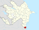
Jabrayil District is one of the 66 districts of Azerbaijan. It is located in the south-west of the country and belongs to the East Zangezur Economic Region. The district borders the districts of Khojavend, Fuzuli, Qubadli, Zangilan, and the Islamic Republic of Iran.

Qazax District is one of the 66 districts of Azerbaijan. Located in the northwest of the country, it belongs to the Gazakh-Tovuz Economic Region. The district borders the district of Aghstafa, and the Tavush Province of Armenia. Its capital and largest city is Gazakh. As of 2020, the district had a population of 98,400.

Zagatala District is one of the 66 districts of Azerbaijan. It is located in the north of the country and belongs to the Shaki-Zagatala Economic Region. The district borders the districts of Balakan, Qakh, as well as the Kakheti region of Georgia and the Russian Republic of Dagestan. Its capital and largest city is Zagatala. As of 2020, the district had a population of 129,800.
Tartar District is one of the 66 districts of Azerbaijan. It is located in the west of the country and belongs to the Karabakh Economic Region. The district borders the districts of Kalbajar, Goranboy, Yevlakh, Barda, and Aghdam. Its capital and largest city is Tartar. As of 2020, the district had a nominal population of 104,700. In March 2023, Azerbaijan began resettling the part of the district that was previously controlled by Armenian forces. Resettlement of the village by Azerbaijan began in March 2023, with 20 families moving back to Talish.

Zangilan District is one of the 66 districts of Azerbaijan. It is located in the south-west of the country and belongs to the East Zangezur Economic Region. The district borders the districts of Qubadli, Jabrayil, the Syunik Province of Armenia and the East Azerbaijan Province of Iran. Its capital and largest city is Zangilan. As of 2020, the district had a nominal population of 45,200.

Khojavend District is one of the 66 districts of Azerbaijan. It is located in the west of the country in the Karabakh Economic Region. The district borders the districts of Lachin, Shusha, Khojaly, Aghdam, Aghjabadi, Fuzuli, Jabrayil, and Qubadli. Its capital and largest city is Khojavend. As of 2020, the district had a nominal population of 44,100.

Fuzuli District is one of the 66 districts of Azerbaijan. It is located in the south-west of the country and belongs to the Karabakh Economic Region. The district borders the districts of Khojavend, Aghjabadi, Beylagan, Jabrayil, and the Ardabil Province of Iran.

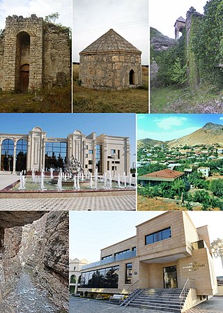
Qubadli is a city in Azerbaijan and the administrative centre of the Qubadli District. It is situated along the Vorotan (Bargushad) river.

The First Nagorno-Karabakh War was an ethnic and territorial conflict that took place from February 1988 to May 1994, in the enclave of Nagorno-Karabakh in southwestern Azerbaijan, between the majority ethnic Armenians of Nagorno-Karabakh backed by Armenia, and the Republic of Azerbaijan with support from Turkey. As the war progressed, Armenia and Azerbaijan, both former Soviet republics, entangled themselves in protracted, undeclared mountain warfare in the mountainous heights of Karabakh as Azerbaijan attempted to curb the secessionist movement in Nagorno-Karabakh.

The Armenian-Azerbaijani war (1918–1920) was a conflict that took place in the South Caucasus in regions with a mixed Armenian-Azerbaijani population, broadly encompassing what are now modern-day Azerbaijan and Armenia. It began during the final months of World War I and ended with the establishment of Soviet rule.
Gülablı, also known as Abdal-Gülablı, is a village in the Aghdam District of Azerbaijan.
Syrkhavend or Nor Ghazanchi is a village located in the Agdam District of Azerbaijan, in the disputed region of Nagorno-Karabakh. The village had an Azerbaijani majority prior to their expulsion during the First Nagorno-Karabakh War.
Çullu is a village situated on Goyan steppe, 27 km west of the city of Jabrayil, within the Dagh Tumas administrative-territorial unit of Jabrayil District, Azerbaijan.
Dağ Tumas is a village in the administrative unit with the same name of Jabrayil District of Azerbaijan, located on the southwestern slopes of Karabakh ridge, 23 km to the west of Jabrayil city.
Bağanıs Ayrım is an abandoned village in the Qazakh District of Azerbaijan. The village was controlled by Armenia from the First Nagorno-Karabakh War in the early 1990s until 2024, when Armenia agreed to return the village to Azerbaijan.

Talish is a village in the Aghdara District in Azerbaijan, in the disputed region of Nagorno-Karabakh. The village had an ethnic Armenian-majority population prior to the 2020 Nagorno-Karabakh war, and also had an Armenian majority in 1989.
Parukh or Farukh, is an Armenian-populated village located in the Khojaly District of Azerbaijan, in the disputed region of Nagorno-Karabakh.
Imar or Karamli is a village located in the Kalbajar District of Azerbaijan, in the region of Nagorno-Karabakh. The village had an Azerbaijani-majority population prior to their expulsion during the Nagorno-Karabakh war.
The Capture of Gushchular and Malibeyli was an incident in which eight ethnic Azerbaijani civilians were killed by Armenian irregular armed units in simultaneous attacks on the villages of Malibeyli, Ashaghi Gushchular, and Yukhari Gushchular in the Shusha District of Azerbaijan, on February 10–12, 1992 during the First Nagorno-Karabakh War.
Üçüncü Milli is a village in the Kalbajar District of Azerbaijan. the village is located in the National Village Administrative Territorial District of Kalbajar District of the Republic of Azerbaijan. By the Decision No. 123-XII of the Supreme Council of the Republic of Azerbaijan dated May 25, 1991, the Third National Village of Sinıqkilsa Village Council of Kalbajar District was included in the First National Village Council. It was occupied by the Armed Forces of the Republic of Armenia in 1993. After the tripartite agreement signed by the heads of state of Azerbaijan, Russia and Armenia on November 10, 2020, the Third National Village was evacuated on November 25, 2020.