
Thuringia, officially the Free State of Thuringia, is a state of central Germany, covering 16,171 square kilometres (6,244 sq mi), the sixth smallest of the sixteen German states. It has a population of about 2.1 million.

Hesse or Hessia, officially the State of Hesse, is a state in Germany. Its capital city is Wiesbaden, and the largest urban area is Frankfurt, which is also the country's principal financial centre. Two other major historic cities are Darmstadt and Kassel. With an area of 21,114.73 square kilometers and a population of over six million, it ranks seventh and fifth, respectively, among the sixteen German states. Frankfurt Rhine-Main, Germany's second-largest metropolitan area, is mainly located in Hesse.
Schmalkalden-Meiningen is a Landkreis in the southwest of Thuringia, Germany. Its neighboring districts are the districts Wartburgkreis, Gotha, Ilm-Kreis, the district-free city Suhl, the district Hildburghausen, the Bavarian district Rhön-Grabfeld, and the district Fulda in Hesse.

The Rhön Mountains are a group of low mountains in central Germany, located around the border area where the states of Hesse, Bavaria and Thuringia come together. These mountains, which are at the extreme southeast end of the East Hesse Highlands, are partly a result of ancient volcanic activity. They are separated from the Vogelsberg Mountains by the river Fulda and its valley. The highest mountain in the Rhön is the Wasserkuppe, which is in Hesse. The Rhön Mountains are a popular tourist destination and walking area.
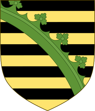
The House of Wettin was a dynasty of German kings, prince-electors, dukes, and counts that once ruled territories in the present-day German states of Saxony, Saxony-Anhalt and Thuringia. The dynasty is one of the oldest in Europe, and its origins can be traced back to the town of Wettin, Saxony-Anhalt. The Wettins gradually rose to power within the Holy Roman Empire. Members of the family became the rulers of several medieval states, starting with the Saxon Eastern March in 1030. Other states they gained were Meissen in 1089, Thuringia in 1263, and Saxony in 1423. These areas cover large parts of Central Germany as a cultural area of Germany.

Saxe-Weimar-Eisenach was a German state, created as a duchy in 1809 by the merger of the Ernestine duchies of Saxe-Weimar and Saxe-Eisenach, which had been in personal union since 1741. It was raised to a grand duchy in 1815 by resolution of the Congress of Vienna. In 1903, it officially changed its name to the Grand Duchy of Saxony, but this name was rarely used. The grand duchy came to an end in the German Revolution of 1918–19 with the other monarchies of the German Empire. It was succeeded by the Free State of Saxe-Weimar-Eisenach, which was merged into the new Free State of Thuringia two years later.

Saxe-Coburg was a duchy held by the Ernestine branch of the Wettin dynasty in today's Bavaria, Germany.

The Ernestine duchies, also known as the Saxon duchies, were a group of small states whose number varied, which were largely located in the present-day German state of Thuringia and governed by dukes of the Ernestine line of the House of Wettin.

Reinhardsbrunn in Friedrichroda near Gotha, in the German state of Thuringia, is the site of a formerly prominent Benedictine abbey, the house monastery of the Ludovingian Landgraves of Thuringia abbey extant between 1085 and 1525. Later used as an administrative seat by the Ernestine dukes of Saxony, the property was turned into a castle and park erected by the Dukes of Saxe-Coburg and Gotha from 1827.

Geisa is a town in the Wartburgkreis district, in Thuringia, Germany. It is situated in the Rhön Mountains, 26 km northeast of Fulda. The near border with Hesse was the border between West Germany and the GDR during the Cold War. Thus, Geisa was in the East German border restriction area of the former inner German border, which meant that until reunification access to the town was limited. The town is the westernmost municipality in what was formerly East Germany.

Kaltennordheim is a town in the Schmalkalden-Meiningen district, in Thuringia, Germany. It is situated in the Rhön Mountains, 22 km southwest of Bad Salzungen, and 35 km east of Fulda. The former municipalities Aschenhausen, Kaltensundheim, Kaltenwestheim, Melpers, Oberkatz und Unterweid were merged into Kaltennordheim in January 2019. At the same time, Kaltennordheim passed from the Wartburgkreis to Schmalkalden-Meiningen.

Saxe-Gotha-Altenburg was a duchy ruled by the Ernestine branch of the House of Wettin in today's Thuringia, Germany. The extinction of the line in 1825 led to a major re-organisation of the Thuringian states.

The House of Henneberg was a medieval German comital family (Grafen) which from the 11th century onwards held large territories in the Duchy of Franconia. Their county was raised to a princely county in 1310.

Oberweid is a municipality in the district Schmalkalden-Meiningen, in Thuringia, Germany. It is part of the Hohe Rhön administrative community, which has its administrative centre in the municipality of Kaltennordheim.

The Diocese of Fulda is a Latin Church diocese of the Catholic Church in the north of the German state of Hessen. It is a suffragan diocese of the Archdiocese of Paderborn. The bishop's seat is in Fulda Cathedral.

The Thuringian states refers to the following German federal states within the German Reich:
The Duchy of Thuringia was an eastern frontier march of the Merovingian kingdom of Austrasia, established about 631 by King Dagobert I after his troops had been defeated by the forces of the Slavic confederation of Samo at the Battle of Wogastisburg. It was recreated in the Carolingian Empire and its dukes were appointed by the king until it was absorbed by the Saxon dukes in 908. From about 1111/12 the territory was ruled by the Landgraves of Thuringia as Princes of the Holy Roman Empire. When Frederick IV, the last independent ruler of Thuringia died in 1440, the territory passed to his nephew, the Saxon elector Frederick II.

The Heldburger Land was the historical, Saxon, administrative district (Amtsbezirk) of Heldburg and is today the southernmost part of the Free State of Thuringia and the district of Hildburghausen, between the towns of Coburg, Hildburghausen and Bad Königshofen. The region known now as the Heldburger Land is referred to administratively as the Heldburger Unterland, and sometimes in the vernacular as the Heldburger Zipfel.

The Rhön Cycleway is a cycle path in Germany that runs for 180 kilometres from Bad Salzungen to Hammelburg. Its route takes it through 3 states: from Thuringia via Hesse to Bavaria.


