
The Andes, Andes Mountains or Andean Mountains are the longest continental mountain range in the world, forming a continuous highland along the western edge of South America. The range is 6,999 km (4,349 mi) long, 200 to 700 km wide, and has an average height of about 4,000 m (13,123 ft). The Andes extend from north to south through seven South American countries: Venezuela, Colombia, Ecuador, Peru, Bolivia, Chile, and Argentina.

Bogotá, officially Bogotá, Distrito Capital, abbreviated Bogotá, D.C., and formerly known as Santa Fe de Bogotá during the Spanish period and between 1991 and 2000, is the capital of Colombia, and one of the largest cities in the world. The city is administered as the Capital District, as well as the capital of, though not part of, the surrounding department of Cundinamarca. Bogotá is a territorial entity of the first order, with the same administrative status as the departments of Colombia. It is the political, economic, administrative, and industrial center of the country.
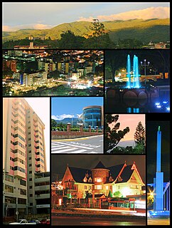
San Cristóbal is the capital city of the Venezuelan state of Táchira. It is located in a mountainous region of Western Venezuela. The city is situated 818 metres (2,684 ft) above sea level in the northern Andes overlooking the Torbes River, 56 kilometres (35 mi) from the Colombian border. San Cristóbal was founded on March 31, 1561, by Juan de Maldonado. From its inception, the city evolved rapidly as one of the most progressive and important centers of commerce in the country, due primarily to its rich soil and its proximity to the border with Colombia.

Alfonso Bonilla Aragón International Airport formerly known as Palmaseca International Airport is located between Palmira and Cali, the capital of Valle del Cauca Department, Colombia. It is Colombia's fourth-busiest airport in passenger volume, with 5,600,000 people using the airport in 2016, and third largest in area and construction. The airport often serves as the alternate airport for Bogotá - El Dorado Int'l Airport and other Colombian airports.

The University of The Andes, also commonly self-styled as Uniandes, is a private research university located in the city centre of Bogotá, Colombia. Founded in 1948 by a group of Colombian intellectuals led by Mario Laserna Pinzón, it was the first Colombian university established as nonsectarian. Los Andes has consistently been regarded as the best Colombian university and has been considered one of the top 5 Latin American universities and one of the top 250 world universities, according to both the QS World Top University Ranking and the Times Higher Education Classification.

Quibdó is the capital city of Chocó Department, in Western Colombia, and is located on the Atrato River. The municipality of Quibdó has an area of 3,337.5 km² and a population of 129,237, predominantly Afro Colombian and Zambo Colombians.

Valera is a city in Trujillo State in Venezuela, situated between the rivers Momboy and Motatán. The current mayor is José Karkom, who has had that post since 2013. The city is home to Italian, Portuguese, Chinese, Colombian and Spanish communities. It is also home to the Universidad Valle del Momboy, a private university, as well as the Instituto Universitario de Tecnología de Trujillo (IUTET). Also, the Universidad Nacional Experimental Simón Rodríguez (UNESR), the Universidad Pedagógica Experimental Libertador (UPEL), among others.

The Cordillera Oriental is the widest of the three branches of the Colombian Andes. The range extends from south to north dividing from the Colombian Massif in Huila Department to Norte de Santander Department where it splits into the Serranía del Perijá and the Cordillera de Mérida in Venezuelan Andes. The highest peak is Ritacuba Blanco at 5,410 m (17,750 ft) in the Sierra Nevada del Cocuy.

The Tropical Andes is northern of the three climate-delineated parts of the Andes, the others being the Dry Andes and the Wet Andes. The Tropical Andes' area spans 1,542,644 km2 (595,618 sq mi).

The Andean region, located in central Colombia, is the most populated natural region of Colombia. With many mountains contains most of the country's urban centers. They were also the location of the most significant pre-Columbian indigenous settlements. Beyond the Colombian Massif in the south-western departments of Cauca and Nariño, the Colombian Andes divide into three branches known as "cordilleras" : the West Andes run adjacent to the Pacific coast and is home to the city of Cali. The Central Andes run up the center of the country between the Cauca and Magdalena river valleys and includes the cities of Medellín, Manizales and Pereira. The East Andes extend northeast towards the Guajira Peninsula, and includes the cities of Bogotá, Bucaramanga and Cúcuta.

Amazonía region in southern Colombia comprises the departments of Amazonas, Caquetá, Guainía, Guaviare, Putumayo and Vaupés, and covers an area of 483,000 km², 35% of Colombia's total territory. The region is mostly covered by tropical rainforest, or jungle, which is a part of the greater Amazon rainforest.

The contribution of travel and tourism to GDP was US$5,880.3bn in 2016. Tourism generated 556,135 jobs in 2016. Foreign tourist visits were predicted to have risen from 0.6 million in 2007 to 4 million in 2017. Responsible tourism became a peremptory need for Colombia because it minimizes negative social, economic and environmental impacts and makes positive contributions to the conservation of natural and cultural heritage.

Captain Luis Fernando Gómez Niño Air Base (Spanish: Base Aérea Capitán Luis Fernando Gómez Niño, also known as Apiay Air Base, is a Colombian military base assigned to the Colombian Air Force Combat Air Command No. 2. It also hosts members of the Colombian Army and Colombian Navy. The base is located in Apiay, near the city of Villavicencio, in the Department of Meta in central Colombia, by the steps of the Andes mountain range and the plains of the Colombian Llanos.

Emeralds are green precious gemstones that are mined in various geological settings. They are minerals in the beryl group of silicates. For more than 4,000 years, emeralds have been among the most valuable of all jewels. Colombia, located in northern South America, is the country that mines and produces the most emeralds for the global market, as well as the most desirable. It is estimated that Colombia accounts for 70–90% of the world's emerald market. While commercial grade emeralds are quite plentiful, fine and extra fine quality emeralds are extremely rare. Colombian emeralds over 50 carat can cost much more than diamonds of the same size.
Alberto Lleras Camargo Airport is a high-elevation airport 6 kilometres (3.7 mi) southwest of the city of Sogamoso in the Boyacá Department of Colombia.
Los Pozos Airport is an airport serving the city of San Gil in the Santander Department of Colombia.
Furatena Airport is an airport serving the emerald region of the western emerald belt and town of Quípama in the Boyacá Department of Colombia. The airport is four nautical miles west of Muzo Airport.
Málaga Airport is an airport serving the town of Málaga, in the Santander Department of Colombia. The airport and town are halfway up a major north–south ridge in the eastern Colombian Andes. The runway is on the northern edge of the town.

Manuel Turizo Zapata, better known as Manuel Turizo and by the acronym MTZ, is a Colombian reggaeton singer. Born and raised in Montería, he began making music at age thirteen. He rose to popularity with his single "Una Lady Como Tú" (2016). He released his debut album ADN on August 23, 2019. Turizo's music contains influences from pop music, trap, and vallenato and his vocal range has been classified as baritone.

