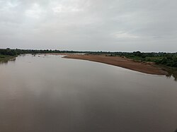
The Godavari is India's second longest river after the Ganga river and drains into the third largest basin in India, covering about 10% of India's total geographical area. Its source is in Trimbakeshwar, Nashik, Maharashtra. It flows east for 1,465 kilometres (910 mi), draining the states of Maharashtra (48.6%), Telangana (18.8%), Andhra Pradesh (4.5%), Chhattisgarh (10.9%) and Odisha (5.7%). The river ultimately empties into the Bay of Bengal through an extensive network of distributaries. Measuring up to 312,812 km2 (120,777 sq mi), it forms one of the largest river basins in the Indian subcontinent, with only the Ganga and Indus rivers having a larger drainage basin. In terms of length, catchment area and discharge, the Godavari is the largest in peninsular India, and had been dubbed as the Dakshina Ganga.

The rusty-spotted cat is one of the cat family's smallest members, of which historical records are known only from India and Sri Lanka. In 2012, it was also recorded in the western Terai of Nepal. Since 2016, the global wild population is listed as Near Threatened on the IUCN Red List as it is fragmented and affected by loss and destruction of its prime habitat, deciduous forests.
Vidarbha is a geographical region in the east of the Indian state of Maharashtra and a proposed state of western India, comprising the state's Amravati and Nagpur divisions. Amravati Division's former name is Berar. It occupies 31.6% of the total area and holds 21.3% of the total population of Maharashtra. It borders the state of Madhya Pradesh to the north, Chhattisgarh to the east, Telangana to the south and Marathwada and Uttar Maharashtra regions of Maharashtra to the west. Situated in central India. The largest city in Vidarbha is Nagpur followed by Amravati, Akola, Chandrapur and Gondia. A majority of Vidarbha residents speak Varhadi and Zadi dialects of Marathi.

Chandrapur district is a district in the Nagpur Division in the Indian state of Maharashtra. Chandrapur was the largest district in India until the Gadchiroli and Sironcha tehsils were separated as Gadchiroli district in 1981. In 2011, the district population was 2,204,307.

Chandrapur is a city and a municipal corporation in Chandrapur district, Maharashtra state, India. It is the district headquarters of Chandrapur district. Chandrapur is a fort city founded by Khandkya Ballal Sah, a Gond king of the 13th century. The city sits at the confluence of the Erai river and Zarpat river. The area around the city is rich in coal seams.. Hence, Chandrapur is also known as the "Black Gold City".

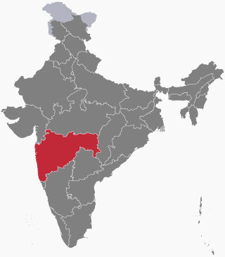
The word Maharashtra, the land of the mainly Marathi-speaking people, appears to be derived from Maharashtri, an old form of Prakrit. Some believe that the word indicates that it was the land of the Mahars and the Rattas, while others consider it to be a corruption of the term 'Maha Kantara', a synonym for 'Dandakaranya'. Maharashtra is the third largest state in India after Rajasthan and Madhya Pradesh. It covers an area of 307,713 km2 and is bordered by the states of Madhya Pradesh to the north, Chhattisgarh to the east, Telangana to the southeast, Karnataka to the south and Goa to the southwest. The state of Gujarat lies to the northwest, with the Union territory of Dadra and Nagar Haveli sandwiched between the borders. Maharashtra has coastline of 720 km.The Arabian Sea makes up Maharashtra's west coast. Maharashtra consists of two major relief divisions. The plateau is a part of the Deccan tableland and the Konkan coastal strip abutting on the Arabian Sea.
Chimur is a city and a municipal council in Chandrapur District, in the state of Maharashtra, India. It is one of the Indian Parliamentary Constituencies and a Vidhan Sabha constituency.

Maharashtra attracts tourists from other Indian states and foreign countries. It was the second most visited Indian state by foreigners and fifth most visited state by domestic tourists in the country in 2021. Aurangabad is the tourism capital of Maharashtra.

Kawal Tiger Reserve is a nature preserve located at Jannaram mandal of Mancherial District in the Telangana state of India. The government of India declared Kawal Wildlife Sanctuary to be a Tiger Reserve in 2012. The reserve is the oldest sanctuary in the northern Telangana region of the state. It is well known for its abundant flora and fauna. This sanctuary is catchment for the rivers Godavari and Kadam, which flow towards the south of the sanctuary.

The Tadoba Andhari Tiger Reserve is a wildlife sanctuary in Chandrapur district of Maharashtra state in India. It is Maharashtra's oldest and largest national park. Created in 1955, the reserve includes the Tadoba National Park and the Andhari Wildlife Sanctuary. The reserve consists of 577.96 square kilometres (223.15 sq mi) of reserved forest and 32.51 square kilometres (12.55 sq mi) of protected forest.
Irai Dam is an earthfill and gravity dam on Irai river near Chandrapur and Tadoba Andhari Tiger Project in state of Maharashtra in India. A borderline flood situation was seen in the catchment and the low-lying areas of this dam and the nearby Chargaon dam in September 2012. The situation came under control after the rainfall stopped.
The following outline is provided as an overview of and topical guide to Maharashtra:
Bordharan is a dam in Seloo Tahsil, Wardha District. Formed by the Bor Dam, – and a area of wide spectrum of wildlife, including sambhar, cheetal, barking deer, nilgai, tigers, leopards, and wild dogs. This place has a water reservoir surrounded by hills and beautiful landscape.
Maharashtra Major State Highway 9 also MSH 9 is a Major State Highway that runs south through Nagpur, and Chandrapur districts in the state of Maharashtra. This state highway touches numerous cities and villages VIZ. Nagpur, Umred, Nagbhid, Mul and Chandrapur. Tadoba Andhari Tiger Project and Umred Karhandla Wildlife Sanctuary are along with this highway.
Andhari is a village in the Palghar district of Maharashtra, India. It is located in the Vikramgad taluka.
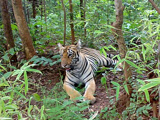
Maharashtra provides legal protection to its tiger population through six dedicated tiger reserves under the precincts of the National Tiger Conservation Authority. under the initiative Project Tiger. These reserves cumulatively cover an estimated area of 9,113 km2 which is about 3% of the total state area.

Tadoba Express is an express train of the Indian Railways connecting Lokmanya Tilak Terminus in Maharashtra and Kazipet Junction of Telangana. It is currently being operated with 15603/15604 train numbers on a daily basis. It is named after Tadoba Andhari Tiger Project.

Ghodazari Wildlife Sanctuary is a wildlife reserve established in 2018 in Nagbhir in the Chandrapur district of the Vidarbha region in Maharashtra, India. It includes 159 km2 (61 sq mi) of southern tropical dry forest and a lake. The forest is considered a key region on the connecting corridor for the tiger migration between the Tadoba Andhari Tiger Project and Umred Karhandala Wildlife Sanctuary. It is named after a village of the same name that is almost in the middle of the forest, about 2 km from the dam and the resort. In Marathi, ghoda means horse and zari means a place with a water spring.
Chandragad Fort / Dhavalgad Fort is a fort located 182 km from Mumbai, in raigad district, of Maharashtra. This fort was an important fort in raigad district as a watch over for the Varandha Ghattrade routes from Bhor to kokan. The fort is surrounded by forest and hill slopes.