The Pyrenees is a mountain range straddling the border of France and Spain. It extends nearly 500 km (310 mi) from its union with the Cantabrian Mountains to Cap de Creus on the Mediterranean coast. It reaches a maximum altitude of 3,404 metres (11,168 ft) at the peak of Aneto.

Huesca, officially Huesca/Uesca, is a province of northeastern Spain, in northern Aragon. The capital is Huesca.

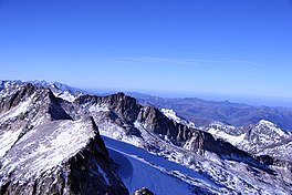
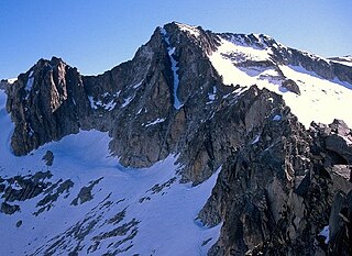
Aneto is the highest mountain in the Pyrenees and in Aragon, and Spain's third-highest mountain, reaching a height of 3,404 metres. It stands in the Spanish province of Huesca, the northernmost of the three Aragonese provinces, 6 kilometres south of the France–Spain border. It forms the southernmost part of the Maladeta massif.

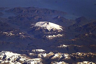
Pico de Orizaba, also known as Citlaltépetl, is an inactive stratovolcano, the highest mountain in Mexico and the third highest in North America, after Denali of Alaska in the United States and Mount Logan of Canada. Pico de Orizaba is also the highest volcanic summit in North America. It rises 5,636 metres (18,491 ft) above sea level in the eastern end of the Trans-Mexican Volcanic Belt, on the border between the states of Veracruz and Puebla. The volcano is currently dormant but not extinct, with the last eruption taking place during the 19th century. It is the second most prominent volcanic peak in the world after Africa's Mount Kilimanjaro.

An ice field is a mass of interconnected valley glaciers on a mountain mass with protruding rock ridges or summits. They are often found in the colder climates and higher altitudes of the world where there is sufficient precipitation for them to form. The higher peaks of the underlying mountain rock that protrude through the icefields are known as nunataks. Ice fields are larger than alpine glaciers, but smaller than ice caps and ice sheets. The topography of ice fields is determined by the shape of the surrounding landforms, while ice caps have their own forms overriding underlying shapes.

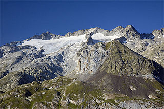
The Vignemale, at 3,298 metres, is the highest of the French Pyrenean summits. It lies on the border between the Department of Hautes-Pyrénées, in Occitanie and Gascony, France and Sobrarbe, in Huesca, Aragon, Spain, and the peak is split between the two countries.

Monte Perdido is the third highest mountain in the Pyrenees. The summit of Monte Perdido (3355 m), located in Spain, lies hidden from France by the seemingly impenetrable peaks of the Cirques of Gavarnie and Estaubé. It stands in the north of Huesca province. The mountain forms part of the Monte Perdido Range and is located in the Ordesa y Monte Perdido National Park, in the western part of the Pyrenees, in the community of Aragon, Spain.

Aagaard Glacier, also known as Glaciar Alderete, is an 8-mile (13 km) long Antarctic glacier which lies close to the east of Gould Glacier and flows in a southerly direction into Mill Inlet, on the east coast of Graham Land. It was charted by the Falkland Islands Dependencies Survey (FIDS) and photographed from the air by the Ronne Antarctic Research Expedition during December 1947; it was named by the FIDS for Bjarne Aagaard, a Norwegian authority on Antarctic whaling and exploration.

The Upsala Glacier is a large valley glacier on the eastern side of the Southern Patagonian Ice Field. Its higher portion lies in a disputed territory between Chile and Argentina. While the glacier flows from north to south it has three lesser eastflowing tributary glacier: Bertacchi, Cono and Murallón.
Melimoyu is a stratovolcano in Chile. It is an elongated volcanic complex that contains two nested calderas of 1 kilometre (0.62 mi) and 8 kilometres (5.0 mi) width. An ice cap has developed on the volcano with a couple of outlet glaciers. Melimoyu has not erupted in recent times, but during the Holocene two large eruptions took place and ejected ash at large distances from the volcano.
Maladeta is a mountain in the Pyrenees, close to the highest peak in the range, Aneto. It is located in the Natural Park of Posets-Maladeta in the town of Benasque in Province of Huesca, Aragon, Spain. Its northern slope contains the 91-acre (37 ha) Maladeta Glacier, which is divided into the 15-acre (6 ha) Western Maladeta and the 77-acre (31 ha) Eastern Maladeta.
Three-thousanders are mountains with a height of between 3,000 metres (9,800 ft), but less than 4,000 metres (13,000 ft) above sea level. Similar terms are commonly used for mountains of other height brackets e. g. four-thousanders or eight-thousanders. In Britain, the term may refer to mountains above 3,000 feet (910 m).

The Exploradores Glacier is a glacier situated on the northeastern slope of Monte San Valentín, in the Aysén del General Carlos Ibáñez del Campo Region of Chile. The locality nearest to the glacier is Puerto Río Tranquilo, which is located on the western shore of General Carrera Lake.
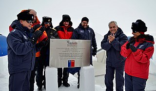
The Estación Polar Científica Conjunta Glaciar Unión or Union Glacier Station is a summer Antarctic base of Chile, situated on Union Glacier in the Ellsworth Mountains. It is jointly operated from November to January by the Chilean Antarctic Institute and the three armed forces of Chile. It was inaugurated on 4 January 2014 by Chilean President Sebastián Piñera Echeñique.

The southernmost persistent glacial masses in Europe are mainly small glaciers, glacierets, and perennial firn fields and patches, located in the highest mountains of the three big southern European peninsulas - the Balkan, the Apennine, and the Iberian, the southernmost ranges of the Alps and the glaciers on the european northwestern slopes of the Greater Caucasus mountains in Russia. There are summer lasting snow patches in Sierra Nevada, in Mount Olympus (40°05′08″), in Mount Korab (41°47′28″), in Rila Mountain, in Picos de Europa (43°11′51″) in the Cantabrian Mountains, in Mount Maglić (43°16′52″) and others. However, none of them have both persistency and indications of dynamic motion. In southern direction, some 4000 km away, are the glaciers in Africa in Rwenzori Mountains (00°23′09″N), Mount Kenya (00°09′03″S) and Mount Kilimanjaro (03°04′33″S).
The Pyrenees conifer and mixed forests is a temperate broadleaf and mixed forests ecoregion in southwestern Europe. It extends along the Pyrenees mountains which run east and west along the border between France and Spain, and includes all Andorra. The ecoregion extends from the lower slopes of the Pyrenees to its highest peaks, which include Aneto, Posets, and Vignemale.
Point of Astorg is a peak in the Spanish Pyrenees which rises to 3,354 m above sea level, in the Maladeta massif. It is the second highest peak in the massif, after Aneto and the fourth highest peak in the Pyrenees, behind Aneto, Pico Posets and Monte Perdido.