Ankers Bower

Last updated

Ankers Bower
Townland
Retail establishments on Sean Costello Street (geograph 5989200).jpg
Shops along R446 road in the northern part of Ankers Bower
Coordinates: 53°25′12″N7°55′32″W / 53.420°N 7.9255°W / 53.420; -7.9255 [1]
Civil parish St. Mary's
County County Westmeath
CountryIreland

Ankers Bower (also Anker's Bower, [3] Ankers' Bower, [4] Ankersbower, [5] or Anchor's Bower [6] ) is a townland and hill in St. Mary's civil parish in the barony of Brawny, County Westmeath, Ireland. [7] It is partly within the former urban district of Athlone. [5] [8] The name may derive from John Ankers, who was vicar of St. Mary's in 1608. [4]

Population and area

The townland of Ankersbower, which has an area of 58.38 acres (23.63 ha), was uninhabited in 1841 and 1851, and had a population of 60 in 1861. [9] The decennial censuses of Ireland from 1841 to 1911 included demographic data broken down by townland, except that from 1871 the area under the jurisdiction of town commissioners was combined into a single figure, with any rural portion of a townland listed separately. The rural portion of Ankersbower in 1871–1911 was uninhabited; its area was 21.96875 acres (8.89044 ha) in 1891 and 22.7625 acres (9.2117 ha) in 1911. [5] [10] A 2003 statutory instrument, the Athlone Town Boundary Alteration Order, 2003, included more of the townland within the Athlone town boundary; [8] the Local Government Reform Act 2014 abolished Athlone town council. [11]

Sitting largely within the town of Athlone in the Athlone East Urban electoral division, the townland had a population of 341 as of the 2011 census. [12]

Related Research Articles

<span class="mw-page-title-main">Athlone</span> Town in counties Roscommon and Westmeath, Ireland

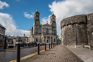
Athlone is a town on the border of County Roscommon and County Westmeath, Ireland. It is located on the River Shannon near the southern shore of Lough Ree. It is the second most populous town in the Midlands Region with a population of 22,869 in the 2022 census.

<span class="mw-page-title-main">Barony (Ireland)</span> Historical subdivision of a county of Ireland

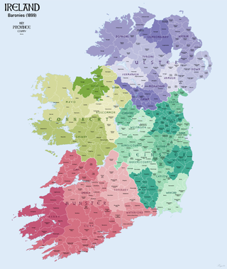
In Ireland, a barony is a historical subdivision of a county, analogous to the hundreds into which the counties of England were divided. Baronies were created during the Tudor reconquest of Ireland, replacing the earlier cantreds formed after the original Norman invasion. Some early baronies were later subdivided into half baronies with the same standing as full baronies.

<span class="mw-page-title-main">1911 census of Ireland</span> Census of Irish population, part of UK census 1911

The 1911 census of Ireland was the last census that covered the whole island of Ireland. Censuses were taken at ten-year intervals from 1821 onwards, but the 1921 census was cancelled due to the Irish War of Independence.

<span class="mw-page-title-main">Carrickfergus (barony)</span> Place in Northern Ireland, United Kingdom

Carrickfergus is a barony in County Antrim, Northern Ireland. It is bounded on the south-east by Belfast Lough, and otherwise surrounded by the barony of Belfast Lower. It is coextensive with the civil parish of Carrickfergus or St Nicholas and corresponds to the former county of the town of Carrickfergus, a county corporate encompassing Carrickfergus town.

Belville is a townland in County Westmeath, Ireland. It is located about 10 miles (16 km) east of Athlone.

St. Doologe's, also St. Doologue's, and formerly St. Tullogue's, or St. Euleck's, is a civil parish in the centre of Wexford town in Ireland.

<span class="mw-page-title-main">Kilkenny West</span> Barony in County Westmeath, Ireland

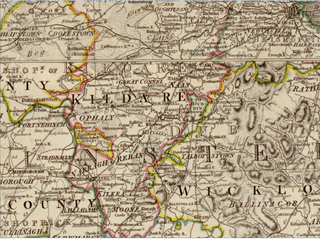
Kilkenny West, previously Maherquirke or Dillons country, is a barony in west County Westmeath, Ireland. It was formed by 1542. It is bordered by County Longford to the west; it is also bordered by three other Westmeath baronies: Rathconrath, Brawny and Clonlonan. The largest centre of population in the barony is the village of Glassan.

<span class="mw-page-title-main">Brawny (barony)</span> Barony in County Westmeath, Ireland

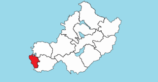
Brawny is a barony in south–west County Westmeath, Ireland. It was formed by 1672. It is bordered by County Roscommon to the west. It also borders two other Westmeath baronies: Kilkenny West and Clonlonan. The largest centre of population in the barony is the town of Athlone.

<span class="mw-page-title-main">Clonlonan</span> Barony in Leinster, Ireland

Clonlonan is a barony in south–west County Westmeath, Ireland. It was formed by 1672. It is bordered by County Offaly to the south and a small part of County Roscommon at Long Island on the River Shannon to the west. It also borders four other Westmeath baronies: Kilkenny West and Rathconrath, Moycashel and Brawny. The largest centre of population in the barony is the town of Moate.

<span class="mw-page-title-main">Ballinalack</span> Townland and village in Leinster, Ireland

Ballinalack is a village and a townland in County Westmeath, Ireland. It is located about 14 kilometres (9 mi) north–west of Mullingar.

<span class="mw-page-title-main">Portnashangan</span> Townland in Leinster, Ireland

Portnashangan is a townland in County Westmeath, Ireland. It is located about 6.81 kilometres (4 mi) north–north–west of Mullingar.

Down is a townland in County Westmeath, Ireland. It is located about 8.17 kilometres (5 mi) north of Mullingar.

<span class="mw-page-title-main">Ballynagall, County Westmeath</span> Townland in Leinster, Ireland

Ballynagall is a townland in County Westmeath, Ireland. It is located about 5.82 kilometres (4 mi) north of Mullingar.

Tybroughney, statutory spelling Tibberaghny, is a civil parish in the barony of Iverk, County Kilkenny in Ireland. The parish comprises a single townland, also called Tibberaghny. It lies on the north bank of the River Suir facing County Waterford, while the Lingaun river separates it from County Tipperary to the west.

St. Marys is a civil parish in County Westmeath, Ireland. It is located about 38.96 kilometres (24 mi) west–south–west of Mullingar.

Clonava is a townland in County Westmeath, Ireland. It is located about 16.31 kilometres (10 mi) north of county town Mullingar.

<span class="mw-page-title-main">Harristown (civil parish)</span> Civil parish in County Kildare, formerly of Kings County

Harristown is a civil parish and electoral division (ED) in County Kildare in Ireland, about 4 miles (6.4 km) southwest of Kildare town.

<span class="mw-page-title-main">Athlone (townland)</span>

Athlone is the name given to two bordering townlands in County Westmeath, Ireland. The townlands are in the civil parish of St. Mary's.

<span class="mw-page-title-main">Athlone North</span> Barony in Connacht, Ireland

Athlone North, also called North Athlone, is a barony in County Roscommon, Ireland. Baronies were mainly cadastral rather than administrative units. They acquired modest local taxation and spending functions in the 19th century before being superseded by the Local Government (Ireland) Act 1898.

<span class="mw-page-title-main">Athlone South</span> Barony in Connacht, Ireland

Athlone South, also called South Athlone, is a barony in County Roscommon, Ireland. Baronies were mainly cadastral rather than administrative units. They acquired modest local taxation and spending functions in the 19th century before being superseded by the Local Government (Ireland) Act 1898.

References

  1. "Map centred on Ankers Court". Google Maps . Retrieved 4 February 2015.
  2. "Map centred on Ankers Court". Google Maps . Retrieved 4 February 2015.
  3. "25-inch Map centred on Anker's Bower". Mapviewer. Ordnance Survey Ireland. c. 1912. Archived from the original on 29 August 2012. Retrieved 3 February 2015.
  4. 1 2 Langrishe, Richard (1890). "The Walls of Athlone (in "Proceedings and Papers")". Journal of the Royal Society of Antiquaries of Ireland. Fifth Series, Vol. 1 (3): 184. JSTOR   25507728.
  5. 1 2 3 "Table VII. Area, houses, out-offices and farm steadings, and population, together with the valuation of each poor law union (or superintendent registrar's district), dispensary (or registrar's) district, district electoral division, townland, etc., in 1911; Athlone Union; Athlone No. 1 District". Census of Ireland 1911; Area, houses, and population; Leinster, Ireland; County of Westmeath. Command papers. Vol. Cd-6049-X. London: HMSO. 1912. p. 6.
  6. Lewis, Samuel (1837). "Appendix: Boundaries of the Cities and Boroughs in Ireland". Topographical Dictionary of Ireland. Retrieved 3 February 2015.
  7. "Ankers Bower". Placenames Database of Ireland . Retrieved 3 February 2015.
  8. 1 2 "S.I. No. 704/2003 - Athlone Town Boundary Alteration Order, 2003". Irish Statute Book . Retrieved 5 February 2015.
  9. "County of Westmeath; Baronies, parishes, townlands and towns; Barony of Brawny". Census of Ireland 1861; Part I: Area, population and number of houses; Vol. I: Province of Leinster. Dublin: Alexander Thom for HMSO. 1863. p. 259.
  10. "Table VII. Area, houses, out-offices and farm steadings, and population, together with the valuation of each parish, townland, and township in 1891; Barony of Brawny; St. Mary's Parish". Census of Ireland 1891; Part I: Area, houses, and population; Vol. I: Leinster; No.10: Westmeath. Command papers. Vol. C-6515-IX. Dublin: Alexander Thom for HMSO. 1891. p. 869.
  11. "Local Government Reform Act 2014, Section 24". Irish Statute Book . Retrieved 5 February 2015.; and
    "S.I. No. 216/2014 - Local Government Reform Act 2014 (Transfer Date) Order 2014". Irish Statute Book . Retrieved 5 February 2015.
  12. "CD172 - Westmeath Population by Private Households, Occupied and Vacancy Rate". data.gov.ie. Central Statistics Office. Retrieved 5 July 2022. Ankers Bower, Athlone East Urban, Co. Westmeath [..] 341