Anne Arundel County Public Library

Last updated
Anne Arundel County Public Library (AACPL)
Location Anne Arundel County, Maryland
Type Public Library
Established1921
Branches16 [1]
Other information
DirectorSkip Auld [2]
Websitewww.aacpl.net

Anne Arundel County Public Library (AACPL) is a public library system located in central Maryland. Established in 1921 as the Annapolis and Anne Arundel County Public Library, Inc, the system now includes 16 locations throughout Anne Arundel County, Maryland. [3]

Contents

Branches

History

The first known public library in Anne Arundel County opened on Jan. 8, 1921, located inside Annapolis City Hall. A library card cost a reported 10 cents at the time. [4] The Glen Burnie Free Public Library opened in 1923 in a Masonic Temple located on Crain Highway. [5] The Public Library Association of Annapolis and Anne Arundel County was incorporated in 1936. [6] According to some reports, Eliza Suydam was the first librarian in the system. [7]

The Annapolis library moved to a location on Church Circle in 1939. The Farmers Bank of Maryland deeded the property to the Public Library Association of Anne Arundel County from 1939-1974. [8]

As part of the Annapolis and Anne Arundel Library System, the Glen Burnie Library formed as a branch library in 1953 located in Glen Burnie High School. Later, the Glen Burnie library moved to a house on Cotter Road in the Harundale neighborhood. It moved again to the Kuethe Library, where it remained until 1991. The Kuethe Library still exists but is not part of the AACPL system. The North County library opened at 1010 Eastway, an access road parallel to Route 2, in 1969. It was renamed Glen Burnie Regional Library in 2014, and renamed again in 2019 as the Glen Burnie library [9]

In 1969 the West County Area Library opened in a church building provided by the Soroptimist Club of Severn. In 2004 it moved to its current location on Annapolis Road and was renamed Odenton library. [10]

In 1961, the Riviera Beach Library opened in a rented store in Pasadena, Maryland. It moved to its present location on Fort Smallwood Road in 1971. This location is undergoing renovation and the library was relocated to a temporary site in 2022. [11]

The first library in Severna Park was located in the former Baltimore and Annapolis Railroad Station building beginning in 1960. In 1972 it moved to its iconic round building on West McKinsey Road. [12]

AACPL opened Discoveries at the Westfield Annapolis Mall as pilot program in 2018. It contains a programming room and a community pantry, and laptop computers are available for use. The location has become a permanent part of the library system. [13]

The system's newest facility is the Michael E. Busch Annapolis Library, which replaced the aging Annapolis Regional Library building. The new library is located on the same site as the previous library and opened in 2020 and cost a reported $24 million. [14] It is named for Michael E. Busch, former Delegate and Speaker of the Maryland House of Delegates representing Annapolis. [15] [16]

Statistics

Governance

AACPL is governed by a board of trustees composed of 17 volunteer members, directors, and executive committee officers. Seven members are nominated by the County Council, and one is recommended by the County Executive. All members of the Board of Library Trustees are appointed by the Board of Library Trustees to three-year terms. [19]

Happenings Newsletter

AACPL publishes a quarterly newsletter titled Happenings. The newsletter showcases upcoming events, programs, and information about the library system. [20]

Privileges

AACPL is part of the Maryland State Library System. As the state library agency for Maryland, the Maryland State Library Agency administers State and Federal funds to support Maryland libraries. Maryland residents are entitled to obtain a library card at no charge from any county or Baltimore City public library. [21]

See also

Related Research Articles

<span class="mw-page-title-main">Anne Arundel County, Maryland</span> County in Maryland, United States

Anne Arundel County, also notated as AA or A.A. County, is located in the U.S. state of Maryland. As of the 2020 United States census, its population was 588,261, an increase of just under 10% since 2010. Its county seat is Annapolis, which is also the capital of the state. The county is named for Anne Arundell, Lady Baltimore, a member of the ancient family of Arundells in Cornwall, England, and the wife of Cecilius Calvert, 2nd Baron Baltimore (1605–1675), founder and first lord proprietor of the colony Province of Maryland.

<span class="mw-page-title-main">Interstate 97</span> Short Interstate Highway in Maryland

Interstate 97 (I-97) is a north-south Interstate Highway in the eastern United States. It runs entirely within Anne Arundel County, Maryland for 17.62 miles (28.36 km) from U.S. Route 50/U.S. Route 301 (US 50/US 301) in Parole near Annapolis north to I-695 and I-895 in Brooklyn Park near Baltimore. The Interstate is the primary highway between Baltimore and Annapolis. I‑97 connects Annapolis with Baltimore/Washington International Airport and links the northern Anne Arundel County communities of Crownsville, Millersville, Severna Park, Glen Burnie, and Ferndale. It is the second shortest primary Interstate Highway after I-87 in North Carolina.

<span class="mw-page-title-main">Fort Meade, Maryland</span> Census-designated place in Maryland, United States

Fort Meade is a census-designated place (CDP) in Anne Arundel County, Maryland, United States. The population was 9,327 at the 2010 census. It is the home to the National Security Agency, Central Security Service, United States Cyber Command and the Defense Information Systems Agency, which are located on the U.S. Army post Fort George G. Meade.

<span class="mw-page-title-main">Glen Burnie, Maryland</span> Census-designated place in Maryland, United States

Glen Burnie is an unincorporated town and census-designated place (CDP) in Anne Arundel County, Maryland, United States. It is a suburb of Baltimore. The population was 72,891 at the 2020 census.

<span class="mw-page-title-main">Odenton, Maryland</span> Census-designated place in Maryland, U.S.

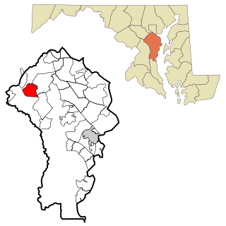
Odenton is a census-designated place (CDP) in Anne Arundel County, Maryland, United States, located approximately 10–20 minutes from the state capital, Annapolis. The population was 37,132 at the 2010 census, up from 20,534 at the 2000 census. The town's population growth rate of 80.8% between 2000 and 2010 was the greatest of any town in western Anne Arundel County. Odenton is located west of Annapolis, south of Baltimore, and northeast of Washington.

<span class="mw-page-title-main">Parole, Maryland</span> Census-designated place in Maryland, United States

Parole, a suburb of Annapolis, is a census-designated place (CDP) in Anne Arundel County, Maryland, United States. The population was 15,922 at the 2010 census. It has several major roads intersect at the western edge of the state capital, Annapolis, and it contains the Annapolis Mall, a number of other large shopping centers, and the Anne Arundel Medical Center. It is generally considered to be part of Annapolis, rather than a separate town. The neighborhood was named because it was a parole camp, where Union and Confederate prisoners of war were brought for mutual exchange and eventual return to their respective homes.

<span class="mw-page-title-main">Maryland Route 2</span> State highway in Maryland, US

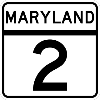
Maryland Route 2 is the longest state highway in the U.S. state of Maryland. The 79.24-mile (127.52 km) route runs from Solomons Island in Calvert County north to an intersection with U.S. Route 1 /US 40 Truck in Baltimore. The route runs concurrent with MD 4 through much of Calvert County along a four-lane divided highway known as Solomons Island Road, passing through rural areas as well as the communities of Lusby, Port Republic, Prince Frederick, and Huntingtown. In Sunderland, MD 2 splits from MD 4 and continues north as two-lane undivided Solomons Island Road into Anne Arundel County, still passing through rural areas. Upon reaching Annapolis, the route runs concurrent with US 50/US 301 to the north of the city. Between Annapolis and Baltimore, MD 2 runs along the Governor Ritchie Highway, a multilane divided highway that heads through suburban areas, passing through Arnold, Severna Park, Pasadena, Glen Burnie, and Brooklyn Park. In Baltimore, the route heads north on city streets and passes through the downtown area of the city.

<span class="mw-page-title-main">Maryland Route 10</span> State highway in Anne Arundel County, Maryland, US, known as the Arundel Expressway

Maryland Route 10 is a state highway in the U.S. state of Maryland. Known as the Arundel Expressway, the highway runs 7.17 miles (11.54 km) from MD 2 in Pasadena north to Interstate 695 (I-695) near Glen Burnie. MD 10 is a four- to six-lane freeway that serves as a bypass of MD 2 through Pasadena and Glen Burnie in northeastern Anne Arundel County. The Arundel Expressway was planned as a Baltimore–Annapolis freeway to provide relief to MD 2 between the cities as early as the 1950s. However, the portion of MD 10 south of Pasadena was removed from state plans when the I-97 corridor was chosen for the intercity freeway in the 1970s. MD 10 was constructed from I-695 to MD 710 in the early 1970s and continued south to MD 648 in the late 1970s. The freeway was extended south to MD 100 and completed to MD 2 in the late 1980s and early 1990s, respectively.

<span class="mw-page-title-main">Maryland Route 648</span> Highway in Maryland

Maryland Route 648 is a collection of state highways in the U.S. state of Maryland. These nine highways are current or former sections of the Baltimore–Annapolis Boulevard between Annapolis and Baltimore via Glen Burnie. There are five signed mainline segments of MD 648 through Arnold, Severna Park, Pasadena, Glen Burnie, Ferndale, and Pumphrey in northern Anne Arundel County; Baltimore Highlands in southern Baltimore County; and the independent city of Baltimore. MD 648 mainly serves local traffic along its meandering route, with long-distance traffic intended to use the parallel and straighter MD 2 south of Glen Burnie and freeway-grade Interstate 97 (I-97), I-695, and MD 295 between Glen Burnie and Baltimore.

<span class="mw-page-title-main">Maryland Route 170</span> State highway in Anne Arundel County, Maryland, United States

Maryland Route 170 is a state highway in the U.S. state of Maryland. The state highway runs 12.98 miles (20.89 km) from MD 175 in Odenton north to MD 2 in Brooklyn Park. MD 170 connects the western Anne Arundel County communities of Odenton and Severn and the North County communities of Linthicum, Pumphrey, and Brooklyn Park with Baltimore/Washington International Thurgood Marshall Airport. The highway connects BWI Airport with Interstate 695 (I-695) and MD 100 and forms part of the Airport Loop, a circumferential highway that connects the airport and I-195 with many airport-related services.

Old Mill High School is a public high school in Millersville, Maryland, serving students in grades 9 through 12. It was occupied in 1975 and is administered by Anne Arundel County Public Schools (AACPS). The school was built to alleviate overcrowding at Arundel and Severna Park High Schools. The school has no walls or ceilings in some classrooms, only partitions to separate classrooms. Along with Annapolis High School and Meade Senior High School, Old Mill Senior High is one of the three IB World Schools in Anne Arundel County. The school building also houses the high school's two feeder schools, Old Mill Middle School North and Old Mill Middle School South. The school mascot is the patriot.

The Baltimore & Annapolis Trail is a 13.3-mile (21.4 km) rail trail in Anne Arundel County, Maryland. The trail starts at Boulter's Way in Arnold and ends near Baltimore Light Rail's Cromwell Station in Glen Burnie. Starting near Annapolis at Jonas Green Park, the trail passes (northward) through Arnold, Severna Park, Millersville, Pasadena, and Glen Burnie. The Baltimore & Annapolis Trail follows the route of the Baltimore & Annapolis Railroad from which it derives its name. Proposed in 1972 by Jim Hague, it opened on Oct 7, 1990 as the second rail trail in Maryland.

The Washington, Baltimore and Annapolis Trail (WB&A) is a 10.25-mile (16.50 km) long discontinuous rail trail from Lanham to Odenton in Maryland. Despite its name, it does not actually connect with Washington, D.C., Annapolis or Baltimore; its name is taken from the Washington, Baltimore and Annapolis Electric Railway, from which the right-of-way comes. The trail exists in two separate pieces, one in Anne Arundel County and the other in Prince George's County, separated by the lack of a bridge over the Patuxent River. The bridge's construction and the trail's alignment was delayed for over a decade due to a property dispute; however, the trail was realigned and plans exist to complete a bridge by 2021. Additional plans exist to extend the trail southward to the Washington, D.C. border.

<span class="mw-page-title-main">Maryland Route 176</span> State highway in Maryland, U.S., known as Dorsey Rd

Maryland Route 176 is a state highway in the U.S. state of Maryland. Known as Dorsey Road, the highway runs 5.68 miles (9.14 km) from the end of state maintenance in Hanover east to MD 648 in Glen Burnie. MD 176 is a mostly four-lane highway that parallels MD 100 and forms the southern portion of the Airport Loop, a circumferential highway around Baltimore/Washington International Thurgood Marshall Airport that connects the airport with various airport-related services. The highway serves as the main connection between the Airport Loop and Interstate 97 (I-97).

<span class="mw-page-title-main">Maryland Route 174</span> State highway in Anne Arundel County, Maryland, United States

Maryland Route 174 is a state highway in the U.S. state of Maryland. The highway runs 5.94 miles (9.56 km) from Jacobs Road near Fort Meade east to MD 3 Business in Glen Burnie. MD 174 connects Glen Burnie with Severn and Fort George G. Meade in northern Anne Arundel County. The Fort Meade–Severn portion of the highway was constructed as part of MD 170, the primary highway that connected what was then Camp Meade to Baltimore, in the late 1910s. The highway was widened in the early 1940s, then became MD 554 in a number swap with the Severn–Odenton portion of MD 170. MD 174 was constructed in the early 1920s as a short road from MD 3 in Glen Burnie west to the site of the highway's modern Interstate 97 (I-97) interchange. MD 174 was extended west to Fort Meade in the early 1980s.

<span class="mw-page-title-main">Severna Park High School</span> Public school in Severna Park, Maryland, United States

Severna Park High School is a public high school in the United States located in the suburban CDP of Severna Park, Maryland. It is a part of the Anne Arundel County Public Schools system. SPHS opened its doors to students in 1959 and was the seventh public high school opened in Anne Arundel County.. Its principal is Lindsay Abruzzo. A new school was built on the same grounds, and opened in January 2017. The Falcons are sports rivals with nearby Broadneck High School.

<span class="mw-page-title-main">Anne Arundel County Public Schools</span>

Anne Arundel County Public Schools is the public school district serving Anne Arundel County, Maryland. With over 80,000 students, the AACPS school system is the 4th largest in Maryland and the 39th largest in the United States. The district has over 5,000 teachers supporting a comprehensive curriculum from Pre-K through 12th grade.
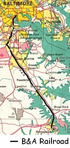
<span class="mw-page-title-main">Baltimore and Annapolis Railroad</span> Defunct railway line in Maryland, US

The Baltimore & Annapolis Railroad was an American railroad of central Maryland built in the 19th century. The railroad, the second to serve Annapolis, ran between Annapolis and Clifford along the north shore of the Severn River. From Clifford, just north of the present day Patapsco Light Rail Stop, it connected with the B&O's Curtis Bay branch so that trains could travel to Baltimore. In 1921, when it was called the Annapolis and Baltimore Short Line, it was purchased by the larger Washington, Baltimore and Annapolis Electric Railway (WB&A), and then emerged from the WB&A's 1935 bankruptcy and closure as the Baltimore & Annapolis Railroad. B&A electric passenger operation between the two cities continued until 1950, at which time the rail line became solely a freight carrier, operating buses for passenger service. Freight service to Annapolis continued until June 1968 when the Severn River Trestle was declared unsafe. In the 1980s, the line was completely shut down. The right-of-way now serves as part of Baltimore's light rail system and as the Baltimore & Annapolis Trail.

<span class="mw-page-title-main">Washington, Baltimore and Annapolis Electric Railway</span>

The Washington, Baltimore and Annapolis Electric Railway (WB&A) was an American railroad of central Maryland and Washington, D.C., built in the 19th and 20th century. The WB&A absorbed two older railroads, the Annapolis and Elk Ridge Railroad and the Baltimore & Annapolis Short Line, and added its own electric streetcar line between Baltimore and Washington. It was built by a group of Cleveland, Ohio, electric railway entrepreneurs to serve as a high-speed, showpiece line using the most advanced technology of the time. It served Washington, Baltimore, and Annapolis, Maryland, for 27 years before the "Great Depression" and the rise of the automobile forced an end to passenger service during the economic pressures of the 1930s "Depression" southwest to Washington from Baltimore & west from Annapolis in 1935. Only the Baltimore & Annapolis portion between the state's largest city and its state capital continued to operate electric rail cars for another two decades, replaced by a bus service during the late 1950s into 1968. Today, parts of the right-of-way are used for the light rail line, rail trail for hiking - biking trails, and roads through Anne Arundel County.

<span class="mw-page-title-main">Maryland Route 270</span>

Maryland Route 270 is a state highway in the U.S. state of Maryland. Known as Furnace Branch Road, the highway runs 2.16 miles (3.48 km) from MD 648 north to MD 3 Business within Glen Burnie in northeastern Anne Arundel County. MD 270 was constructed between a pair of intersections with MD 2 in the early 1930s. The highway was expanded and relocated when MD 10 was constructed through the area in the mid-1970s.

References

  1. "History". AACPL. 2022-03-03. Retrieved 2022-03-03.
  2. "Library Leadership". AACPL. 2022-03-03. Retrieved 2022-03-03.
  3. "Maryland Manual On-line: Department of Libraries". Maryland Manual. 2020-08-12. Retrieved 2022-03-03.
  4. "History". 2022-03-03. Retrieved 2022-03-03.
  5. "Glen Burnie library celebrates 50 years of service". 2019-04-19. Retrieved 2022-03-03.
  6. "History". 2022-03-03. Retrieved 2022-03-03.
  7. "100 Years of the Anne Arundel County Public Library". 2021-03-03. Retrieved 2022-03-03.
  8. "100 Years of the Anne Arundel County Public Library". Visit Annapolis. 2021-03-10. Retrieved 2022-03-03.
  9. "Maryland Manual On-line: Department of Libraries". Maryland Manual. 2020-12-08. Retrieved 2022-03-03.
  10. "Maryland Manual On-line: Department of Libraries". Maryland Manual. 2020-12-08. Retrieved 2022-03-03.
  11. "Maryland Manual On-line: Department of Libraries". Maryland Manual. 2020-12-08. Retrieved 2022-03-03.
  12. "Maryland Manual On-line: Department of Libraries". Maryland Manual. 2020-12-08. Retrieved 2022-03-03.
  13. "Maryland Manual On-line: Department of Libraries". Maryland Manual. 2020-12-08. Retrieved 2022-03-03.
  14. "Michael E. Busch library opens in Annapolis". Business Monthly. 2020-07-28. Retrieved 2022-03-03.
  15. "Maryland Manual On-line: Department of Libraries". Maryland Manual. 2020-12-08. Retrieved 2022-03-03.
  16. "First look: Inside Anne Arundel's new Michael E. Busch Library in Annapolis". Maryland Manual. 2020-07-22. Retrieved 2022-03-03.
  17. "History". 2022-03-03. Retrieved 2022-03-03.
  18. "100 Years of the Anne Arundel County Public Library". Visit Annapolis. 2021-03-10. Retrieved 2022-03-03.
  19. "Maryland Manual On-line: Department of Libraries". Maryland Manual. 2020-12-08. Retrieved 2022-03-03.
  20. "Happenings Newsletter". AACPL. 2022-03-03. Retrieved 2022-03-03.
  21. "About Maryland Public Libraries". Maryland State Library Agency. 2022-03-03. Retrieved 2022-03-03.

38°58′51″N76°34′07″W / 38.9807°N 76.5685°W / 38.9807; -76.5685