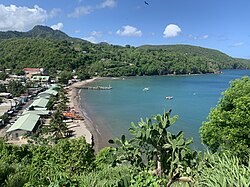
Anse La Raye

Last updated
Anse la Raye
Town
Anse La Raye view.jpg
Overlooking Anse La Raye from the North
Santa lucia anse la raye political.png
Boundary of Anse la Raye District in Saint Lucia with location of city
Coordinates: 13°56′24″N61°02′35″W / 13.9401°N 61.0431°W / 13.9401; -61.0431
Country Saint Lucia
District Anse la Raye District
CityAnse la Raye
Founded18th Century
Founded byFrance
Named for The rays found in the bay
Government
  Governing bodyAnse la Raye Village Council
Elevation
[1]
99 m (325 ft)
Population
 (2010) [2]
  Total6,354 (District) 1,256 (city) [1]
Time zone UTC-4 (Eastern Caribbean Time Zone (ECT))
Area code 758
Website www.anselaraye.com

Anse La Raye or Anse-La-Raye is the largest town and seat of the Anse la Raye District of Saint Lucia. It is located on the island's western side, near Marigot Bay, and has several examples of French and English colonial architecture. [1] [3] [4]

Contents

History

The name Anse la Raye is derived from the rays that are found in the bay, the English translation means Bay of Rays. Two rivers flow into the bay, these are the Grande Rivière de l'Anse la Raye and the Petite Rivière de l'Anse la Raye. On a Friday night there is a fish fry where lobsters, fish and lambi (conch) are cooked and eaten. The fish fry is located on Front Street, which runs parallel to the beach. [5]

The local Catholic church was built in 1907, but records show that a chapel has existed since 1765. The present church has murals painted by the St Omer Family. Nearby attractions include the Anse la Raye Falls and the River Rock Falls.

The town is noted for its youth music groups, the "Cecilian Reys" and the "Anse La Raye Youth Orchestra", both of which were formed under the direction of Petronilla Deterville. Performing since 1981 throughout the country, the group aims to expand the cultural experiences of youth from the area. [6] [7]

See also

Scenes

Related Research Articles

<span class="mw-page-title-main">L'Anse-Saint-Jean, Quebec</span> Municipality in Quebec, Canada

L'Anse-Saint-Jean, French for "The Cove of Saint John" is a municipality in the Saguenay–Lac-Saint-Jean region of Quebec, Canada. Its population was 1208 in the Canada 2011 Census.

<span class="mw-page-title-main">Gros Islet District</span> District in St. Lucia

Gros Islet District, one of 10 first order subdivision of the Caribbean island nation of Saint Lucia which includes the island's northernmost point, Cap Point and the notable Cap Estate, where the renowned St. Lucia Golf and Country Club is located. Whilst the town of Gros Islet is an important administrative centre, Rodney Bay is the main financial center of the district.

<span class="mw-page-title-main">Soufrière District</span> Districts in St. Lucia

Soufrière is a district on the Southwest coast of Saint Lucia in the West Indies. Soufrière was the former capital of Saint Lucia during times of French rule. It is now a small fishing port with an emerging tourism industry. It has several tourist sites, including a "drive-in" volcano, the Diamond Botanical Gardens with waterfall and historic mineral baths, plus the nearby beaches of Anse Chastanet to the north and Malgretout to the south.

<span class="mw-page-title-main">Dennery District</span> Quarter and town in St. Lucia

Dennery District is one of 10 districts of the Caribbean island nation of Saint Lucia. The seat of Dennery District is the Dennery Village. The main economic activities are fishing, and the cultivation of lima beans, bananas, and other tropical fruit. The population of the quarter was estimated at 12,876 in 2002 and fell to 12,767 in 2010.

<span class="mw-page-title-main">Anse la Raye District</span> District in Saint Lucia

Anse la Raye District is one of 10 districts of the island nation of St. Lucia in the Caribbean Sea. The name Anse la Raye is French for cover/bay of the rays, since there are a large number of skate fish or rays in the bay. In 2005/2010, the population of the district was 6,382/6,060 people, and they are mainly fishers and agricultural workers. The main town in the area takes the same name as the district and is located down the western coast from Castries, the capital of the country.

<span class="mw-page-title-main">Districts of Saint Lucia</span> First-level administrative divisions of Saint Lucia

The island nation of Saint Lucia is divided into 10 districts. The name Quarters or Quartiers originally came from the French period in Saint Lucia. The 2001 and 2010 Census of Saint Lucia refers to the first level administrative divisions as districts. The FIPS and ISO standards regularly called these divisions quarters or quartiers in French. The former district of Dauphin Quarter was merged into Gros Islet District and the former district of Praslin Quarter was merged into Micoud District.

<span class="mw-page-title-main">Choiseul District</span> District in St. Lucia

Choiseul District is one of the 10 districts of the Caribbean island nation of Saint Lucia. Located on the southwestern side of the island, the district is home to 6,130 people, according to the 2019 census. The seat of Choiseul District is the town of Choiseul.

<span class="mw-page-title-main">Roman Catholic Archdiocese of Castries</span> Latin Catholic ecclesiastical jurisdiction in the Caribbean

The Roman Catholic Archdiocese of Castries is an archdiocese of the Latin Church of the Roman Catholic Church in the Caribbean. The archdiocese consists of the entirety of the former British dependency of Saint Lucia and is a metropolitan see, the suffragans of the Castries Province being the Dioceses of Roseau, Saint George's in Grenada, St. John's-Basseterre and Kingstown. The archdiocese is a member of the Antilles Episcopal Conference.

<span class="mw-page-title-main">Tourism in Saint Lucia</span> Saint Lucia Tourism

Saint Lucia, an island nation in the Caribbean islands, has a relatively large tourism industry. Due to the relatively small land area of the country, most of the governmental promotion is performed by the state-operated Saint Lucia Tourism Authority, led by Executive Chairperson Agnes.

<span class="mw-page-title-main">Canaries, Saint Lucia</span> Place in Canaries Quarter, Saint Lucia

Canaries is a populated place located on the West Coast of Saint Lucia in the Canaries Quarter. It is a small fishing village and it is nestled along the West Coast road, between the towns of Anse La Raye and Soufriere, and there are scenic views from both the Northern and Southern approaches.

Grande-Rivière or variation, may refer to:

The Grande Rivière de l'Anse la Raye is a river of Saint Lucia.

The Petite Rivière de l'Anse La Raye is a river of Saint Lucia.

<span class="mw-page-title-main">Soufrière, Saint Lucia</span> Town in Soufrière Quarter, Saint Lucia

Soufrière is a town on the West Coast of Saint Lucia, in the eastern Caribbean Sea. The town and the surrounding district has a population of 7,935. It was colonized by the French and was the original capital of the island.

<span class="mw-page-title-main">Canaries District</span> Quarter or district of the island nation of Saint Lucia

Canaries District is one of 10 districts of the island nation of St. Lucia in the Caribbean Sea. In 2010, the population of the region was 2,009 people, and they are mainly fishers and agricultural workers. The main town in the area takes the same name as the district and is located down the western coast from Castries, the capital of the country. It is the smallest quarter of Saint Lucia, both by population and area.

Sir Stanislaus James was a Saint Lucian educator, administrator, and former governor-general.

<span class="mw-page-title-main">Petronilla Deterville</span>

Petronilla Deterville, MBE was a St. Lucian musician and composer recognized for her work in founding youth music and theatrical groups. She was honored as a member of the Order of the British Empire for her contributions to the development and preservation of St. Lucia's folk music, as well as her efforts to utilize the arts to expand educational opportunities.

<span class="mw-page-title-main">Saint-Jean River (Saguenay River tributary)</span> River in Quebec, Canada

The Saint-Jean River is a river crossing the municipalities of Rivière-Éternité and L'Anse-Saint-Jean in the Le Fjord-du-Saguenay Regional County Municipality, in the administrative region of Saguenay-Lac-Saint-Jean, Quebec, Canada.

L'Anse Saint-Jean is a bay located on the south shore of the Saguenay River at L'Anse-Saint-Jean, in the Le Fjord-du-Saguenay Regional County Municipality, in Quebec, Canada.

References

  1. 1 2 3 "Anse la Raye". GeoNames. Retrieved August 12, 2021.
  2. "2010 Census". Government of Saint Lucia.
  3. "Government of Saint Lucia". Archived from the original on 2012-05-20. Retrieved 2012-06-17.
  4. There are two spellings, Anse La Raye and Anse-La-Raye. The spelling without the hypen is preferred and used in the Census.
  5. "Discover Anse la Raye". Anse la Raye.
  6. Bishop, Stan (19 January 2016). "Petronilla Deterville's Work Highlighted". Castries, St Lucia: The Voice of St. Lucia. Archived from the original on 25 October 2017. Retrieved 3 November 2017.
  7. "Piper's Song: Volunteerism to Safeguard the Music Art Form" (PDF). National Review. No. 23. Castries, St. Lucia. 24 September 2011. p. 8. Archived from the original (PDF) on 3 November 2017. Retrieved 3 November 2017.