
Colorado is a state in the western United States encompassing most of the southern Rocky Mountains as well as the northeastern portion of the Colorado Plateau and the western edge of the Great Plains. It is the 8th most extensive and 21st most populous U.S. state. The estimated population of Colorado is 5,758,736 as of 2019, an increase of 14.5% since the 2010 United States Census.

Nevada is a state in the Western United States. It is bordered by Oregon to the northwest, Idaho to the northeast, California to the west, Arizona to the southeast, and Utah to the east. Nevada is the 7th-most extensive, the 32nd-most populous, but the 9th-least densely populated of the U.S. states. Nearly three-quarters of Nevada's people live in Clark County, which contains the Las Vegas–Paradise metropolitan area, including three of the state's four largest incorporated cities. Nevada's capital is Carson City.

Clark County is located in the U.S. state of Nevada. As of the 2010 census, the population was 1,951,269, with an estimated population of 2,266,715 in 2019. Most of the county population resides in the Las Vegas Census County Divisions, holding 1,771,945 people as of the 2010 Census, covering the 476 square miles (1,233 km2). It is by far the most populous county in Nevada, accounting for 7% of the state's land area but 74% of the state's population – thus making Nevada one of the most centralized states in the United States.

Southern California ; Spanish: Sur de California) is a geographic and cultural region that generally comprises the southern portion of the U.S. state of California. It includes the Los Angeles metropolitan area, the second most populous urban agglomeration in the United States. The region generally contains ten of California's 53 counties: Imperial, Kern, Los Angeles, Orange, Riverside, San Bernardino, San Diego, Santa Barbara, San Luis Obispo and Ventura counties. The Colorado Desert and the Colorado River are located on southern California's eastern border with Arizona, and San Bernardino County shares a border with Nevada to the northeast. Southern California's southern border with Baja California is part of the Mexico–United States border.

Los Angeles County, officially the County of Los Angeles, is the most populous county in the United States, with more than ten million inhabitants as of 2018. It is the largest non–state-level government entity in the United States. Its population is greater than that of 41 individual U.S. states. It has the third-largest metropolitan economy in the world, with a Nominal GDP of more than $700 billion. It has 88 incorporated cities and many unincorporated areas and, at 4,083 square miles (10,570 km2), it is larger than the combined areas of Delaware and Rhode Island. The county is home to more than one-quarter of California residents and is one of the most ethnically diverse counties in the United States. Its county seat, Los Angeles, is also California's most populous city and the second most populous city in the United States, with about four million residents.

San Bernardino County, officially the County of San Bernardino, is a county located in the southern portion of the U.S. state of California, and is located within the Inland Empire area. As of the 2010 U.S. Census, the population was 2,035,210, making it the fifth-most populous county in California and the 14th-most populous in the United States. The county seat is San Bernardino.

DeKalb County is located in the north central portion of the U.S. state of Georgia. As of the 2010 census, the population was 691,893, making it Georgia's fourth-most populous county. Its county seat is Decatur.

Cobb County is a suburban county of Atlanta in the U.S. state of Georgia, located in the north central portion of the state. As of 2019, the population was 760,141, making it Georgia's third most-populous county. Its county seat and largest city is Marietta.

Mountain View is a city in Santa Clara County, California, United States, in Silicon Valley. Named for its views of the Santa Cruz Mountains, Mountain View is one of the principal cities of Silicon Valley. It has a population of 82,739.

The Catskill Mountains, also known as the Catskills, are a physiographic province of the larger Appalachian Mountains, located in southeastern New York. As a cultural and geographic region, the Catskills are generally defined as those areas close to or within the borders of the Catskill Park, a 700,000-acre (2,800 km2) forest preserve forever protected from many forms of development under New York state law.

The North American Central Time Zone (CT) is a time zone in parts of Canada, the United States, Mexico, Central America, some Caribbean Islands, and part of the Eastern Pacific Ocean.

The Mountain Time Zone of North America keeps time by subtracting seven hours from Coordinated Universal Time (UTC) when standard time (UTC−07:00) is in effect, and by subtracting six hours during daylight saving time (UTC−06:00). The clock time in this zone is based on the mean solar time at the 105th meridian west of the Greenwich Observatory. In the United States, the exact specification for the location of time zones and the dividing lines between zones is set forth in the Code of Federal Regulations at 49 CFR 71.

West Texas is a loosely defined part of the U.S. state of Texas, generally encompassing the arid and semi-arid lands west of a line drawn between the cities of Wichita Falls, Abilene, and Del Rio.
New York most commonly refers to:

In these lists of mountains in Ireland, those within Northern Ireland, or on the Republic of Ireland – United Kingdom border, are marked with an asterisk, while the rest are within the Republic of Ireland. Where mountains are ranked by height, the definition of the topographical prominence used to classify the mountain, is noted. In British definitions, a height of 600 metres (1,969 ft) is required for a mountain, whereas in Ireland, a lower threshold of 500 metres (1,640 ft) is sometimes advocated.
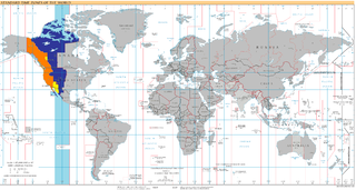
UTC−07:00 is an identifier for a time offset from UTC of −07:00. In North America, it is observed in the Mountain Time Zone during standard time, and in the Pacific Time Zone during the other 8 months. Some locations use it year-round.
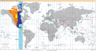
UTC−06:00 is an identifier for a time offset from UTC of −06:00. In North America, it is observed in the Central Time Zone during standard time, and in the Mountain Time Zone during the other eight months. Several Latin American countries and a few other places use it year round.
