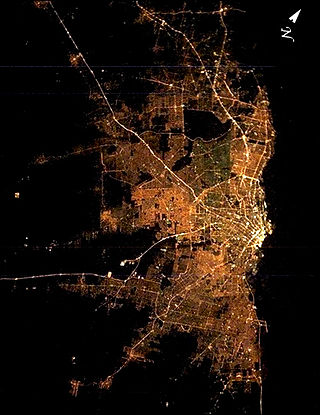
Greater Buenos Aires, also known as the Buenos Aires Metropolitan Area, refers to the urban agglomeration comprising the Autonomous City of Buenos Aires and the adjacent 24 partidos (districts) in the Province of Buenos Aires. Thus, it does not constitute a single administrative unit. The conurbation spreads south, west and north of Buenos Aires city. To the east, the River Plate serves as a natural boundary.
Santos Lugares is a town in the southeast of the partido of Tres de Febrero. It is part of the urban agglomeration of Greater Buenos Aires in Buenos Aires Province, northeast of the Buenos Aires city proper. According to the 2001 census [INDEC], Santos Lugares had 17,023 inhabitants.

The National Institute of Statistics and Censuses is an Argentine decentralized public body that operates within the Ministry of Economy, which exercises the direction of all official statistical activities carried out in the country.

Santo Tomé is a city in the province of Santa Fe, Argentina. It is located only 9 km from the capital city. It has a population of about 65,684 inhabitants and estimated at 80,000 inhabitants based on population growth rate provided by the INDEC, and is classified as a second-category municipality.

Campana is a city in the province of Buenos Aires, Argentina. It is the seat of the Campana Partido. It is located about 75 km (47 mi) from the Autonomous City of Buenos Aires, on the right-hand margin of the Paraná River. Its population is 94,333 inhabitants as per the 2010 census [INDEC].

Junín Partido is a county (partido) in the province of Buenos Aires, Argentina. Its population is 88,664 inhabitants and the population density reaches 39.4 inhabitants/km2. Its administrative seat is the city of Junín.

Belén is a small town in the province of Catamarca, Argentina. It has about 12,000 inhabitants according to the 2001 census [INDEC]. It is the head town of the department of the same name. Belén is the birthplace of author and poet Luis Franco.
Loreto is a city located in central Argentina in the southwest of the province of Santiago del Estero, Argentina. It has 9,854 inhabitants as per the 2001 census [INDEC], and is the head town of the Loreto Department. It is located 59 km south of the provincial capital Santiago del Estero, on National Route 9.

Alberti is a northern central partido of Buenos Aires Province, Argentina, at coordinates 35°02′S60°15′W

The Partido de Bahía Blanca is a partido of the Buenos Aires Province is located at the south-west of the province in central Argentina at coordinates 38°42′S62°16′W
General Rodríguez is a western partido of Buenos Aires Province, in Argentina. It is a district on the far western outskirts of Greater Buenos Aires.

Ambato is a department in the province of Catamarca in the northwest of Argentina. It covers an area of 1761 km2 and features a mountainous terrain throughout. Administratively, it is divided into 7 districts: El Rodeo, Las Juntas, La Puerta, Los Varela, El Bolsón, Singuil, and Los Castillos.

SS Antilla was a Hamburg America Line (HAPAG) cargo ship that was launched in 1939 and scuttled in 1940.
Bernal is a city located in the northeast of Quilmes in the province of Buenos Aires, approximately 10 miles south of the city of Buenos Aires. It is the second largest and most populated city in the Partido of Quilmes. Bernal borders Avellaneda Partido and Lanús Partido to the north-west, the city of Quilmes to the south-east, Almirante Brown Partido and Lomas de Zamora Partido to the south-west the Río de la Plata to the north-east.

Londres is a small tourist town in the Belén Department of Catamarca Province, Argentina. It is situated at 1,170 m (3,839 ft) above sea level alongside the Ruta Nacional 40. It is at the foot of Shincal mountains, near the Quimivil river and is traditionally divided into two parts "Arriba" and "Abajo", divided by the "Hondo" River.
Ciudad Jardín El Libertador is a town in General San Martín Partido of Buenos Aires Province, Argentina. It is located in the Greater Buenos Aires area.
Villa de Pomán is a town and municipality in Catamarca Province in northwestern Argentina.

Iruya is a department is located in the north of Salta Province in northwest Argentina in the high altitude basin of the Bermejo River. It is one of 23 administrative units in the province.
José Marmol is a city in Greater Buenos Aires, Argentina, located 25 km south of Buenos Aires. It belongs to the Almirante Brown Partido (district). It has 5.14 km2, thus occupying 3.97% of the district. Its population was 40,612 inhabitants, grew 4.6% from the 38,842 inhabitants of the previous census, population density of 7,091 inhabitants / km ². In 1991 19.037 men and 19.805 women were counted, according to the 1991 national census. In that year there was also determined 11,290 homes.

Jiménez Department is a department of Argentina in Santiago del Estero Province. The capital city of the department is situated in Pozo Hondo. As of the 2010 census [INDEC], it counted with a population of 14,352 inhabitants.

