
Miryalaguda is a city in Nalgonda district of the Indian state of Telangana. In 2015, the Government of India placed Miryalaguda under the Atal Mission for Rejuvenation and Urban Transformation scheme. It is located about 44 kilometres (27 mi) from the district headquarters Nalgonda, 142 kilometres (88 mi) from the state capital Hyderabad.

Nalgonda is a city and municipality in the Indian state of Telangana. It is the headquarters of the Nalgonda district, as well as the headquarters of the Nalgonda mandal in the Nalgonda revenue division. It is located about 90 kilometres (56 mi) from the state capital Hyderabad.
Nakrekal is a census town in Nalgonda district of the Indian state of Telangana. It is located in Nakrekal mandal in Nalgonda division..It is located about 26km from Suryapet and 29km from Nalgonda.

Nalgonda district is a district in the Telangana state of India. Nalgonda district has the highest number of mandals in the state with 31 mandals. The district shares boundaries with Suryapet, Rangareddy, Yadadri and Nagarkurnool districts and with the state boundary of Andhra Pradesh. In terms of area, Nalgonda is the largest district with an area of 7222.78 km2 in the state.

Devarakonda is a town in the Nalgonda district of the Indian state of Telangana. It is a municipality in Devarakonda mandal of Devarakonda division. It is located about 60 kilometres (37 mi) from the district headquarters Nalgonda, 104 kilometres (65 mi) from the state capital Hyderabad

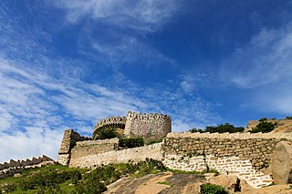
Bhongir, officially known as Bhuvanagiri, is a city and a district headquarters of the Yadadri Bhuvanagiri district and part of the Hyderabad Metropolitan Region of the Indian state of Telangana.

Choutuppal is a census town in Yadadri Bhuvanagiri district of the Indian state of Telangana. It is located in Choutuppal mandal of Choutuppal division. Its part of Hyderabad Metropolitan Development Authority. 49 km from Hyderabad.
Chandur is a census town and Municipality and it is a Mandal Headquarters of Chandur Mandal in Nalgonda district & in the state of Telangana, India. It is located in Chandur mandal of Nalgonda division Postal code or Pin code: 508255. A beautiful and peaceful town. There are various legends about the etymology of the name one of the folklore says Chandi uuru as there is a famous Chandi maata temple of which the deity resembles to the goddess Durga of Vijayawada and is said to be commenced at the same time of the famous temple.

Kunduru Jana Reddy is an Indian politician. He was the leader of opposition in first Telangana Assembly and served as the Minister for Panchayat Raj & Rural Water Supply in the State of Andhra Pradesh during its term from 2009 to 2014. He was among the most prominent cabinet ministers of the ruling Indian National Congress (INC) and served as Minister for Home, Jails, Fire Service, Sainik Welfare, Printing & Stationery in the government led by the late former Chief Minister Dr Y. S. Rajasekhara Reddy from 2004 to 2009. In 2009 elections he won with a margin of 6214 votes against industrialist turned politician of TDP Chinappa Reddy Tera. In 2014 he won with a margin of 16558 votes over Nomula Narsimaiah of BRS in the year where Congress lost the majority vote. He lost the 1994 elections to TDP candidate Gundeboina Rammoorthy Yadav.
Nidamanoor is one of the 33 mandals in Nalgonda district of the Indian state of Telangana. It is under the administration of Miryalaguda revenue division. It comes under left canal of Nagarjuna Sagar Dam.

Gutha Sukender Reddy is an Indian BRS politician who is the 2nd and current Chairman of the Telangana Legislative Council since 14 March 2022. He was elected as MLC in 2019 & 2021 respectively.
Nalgonda mandal is one of the 59 mandals in Nalgonda district of the Indian state of Telangana. It is under the administration of Nalgonda revenue division and the headquarters are located at Nalgonda.
Tripuraram is a village in Nalgonda district in Telangana, India. It is located in Tripuraram mandal of Miryalaguda division.
Palem is a village and Gram panchayat of Anumula mandal, Nalgonda district, in Telangana state in India.
Gundlapally is a village in Nalgonda district of Telangana State, India. It is located in.
Nagarjuna Sagar Assembly constituency is a constituency of the Telangana Legislative Assembly, India. It is one of 12 constituencies in the Nalgonda district. It is part of Nalgonda Lok Sabha constituency.

Warangal district, formerly Warangal Rural district, is a district in the Indian state of Telangana. The district shares boundaries with Mahabubabad, Jangaon, Hanamkonda, Mulugu and Bhupalpally districts.
Yadadri Bhuvanagiri District, is a district in the Indian state of Telangana. The administrative headquarters is located at Bhuvanagiri Town. The district shares boundaries with Suryapet, Nalgonda, Jangaon, Siddipet, Medchal-Malkajgiri and Rangareddy districts. It was carved out of Nalgonda district on 11 October 2016 during a large reorganization of the districts of Telangana.
Haliya is a municipality located in Anumula mandal of Nalgonda district, Telangana, India. The population as per the 2011 census is 17371 and its extent is 42.84 km2. It is situated 150 km away from the state capital of Telangana i.e., Hyderabad and is connected to Nagarjuna Sagar road. It is situated 34 km away from Dist. Headquarters Viz., Nalgonda and 31 km away from the division Miryalaguda. The River Krishna is passing by the side of Nagarjuna Sagar which is 25 km away from the town.

