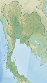
The Gulf of Thailand, also known as the Gulf of Siam, is a shallow inlet in the southwestern South China Sea, bounded between the southwestern shores of the Indochinese Peninsula and the northern half of the Malay Peninsula. It is around 800 km (500 mi) in length and up to 560 km (350 mi) in width, and has a surface area of 320,000 km2 (120,000 sq mi). The gulf is surrounded on the north, west and southwest by the coastlines of Thailand, on the northeast by Cambodia and the Mekong Delta region of Vietnam, and opens to the South China Sea in the southeast.
Prachuap Khiri Khan is one of the western provinces (changwat) of Thailand. It is in the northern part of the Malay Peninsula, some 240 km (149 mi) south of Bangkok. Neighboring provinces include Phetchaburi to the north and Chumphon to the south. To the west, it borders Tanintharyi Region of Myanmar.
Hua Hin is one of eight districts (amphoe) of Prachuap Khiri Khan province in the northern part of the Malay Peninsula in Thailand. Its seat of government, also named Hua Hin, is a beach resort town. The district's population was estimated at 65,983 in December 2019 by the Bureau of Registration Administration in an area of 911 km2 (352 sq mi). By road, it is 199 km (124 mi) south-southwest of Bangkok.
The Battle of Prachuap Khri Khan was an early engagement of the Japanese invasion of Thailand in the Southeast Asian theatre of World War II. It was fought on 8–9 December 1941 at the airfield of Prachuap Khiri Khan, on the coast of the Gulf of Thailand along the Kra Isthmus. The Japanese meant to use Thailand as a base to strike at British possessions in Burma and Malaya and attacked Thailand without warning.

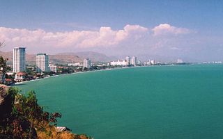
Prachuap Khiri Khan is a town in western Thailand. It is the capital of Prachuap Khiri Khan Province and is on the coast at one of the narrowest stretches in Thailand, only 10 kilometres (6.2 mi) from the border with Myanmar at Dan Sing Khon in the Tenasserim Hills. The area has large pineapple and coconut industries, in addition to being popular with Thai tourists. The town is 291 km south of Bangkok by road.

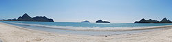
Khao Sam Roi Yot National Park is a marine national park in Kui Buri District, Prachuap Khiri Khan Province, Thailand. It covers 61,300 rai ~ 98 square kilometres (38 sq mi) of which 13,050 rai ~ 21 square kilometres (8.1 sq mi) are marine areas. The park was established in 1966, and was the first coastal national park of Thailand. The park includes Thailand's largest freshwater marsh.

Ko Samet is one of the eastern seaboard islands of Thailand. It is in the Gulf of Thailand off the coastline of the Thai province of Rayong, approximately 220 kilometres (140 mi) southeast of Bangkok. Ko Samet is part of the Phe Subdistrict of the Amphoe Mueang Rayong, of Rayong Province. Ko Samet is the largest and westernmost of a cluster of islands not far from the coast. Ko Samet measures 6.8 kilometres (4.2 mi) from north to south. At its closest point to the mainland, the island is 2.6 kilometres (1.6 mi) south of mainland Rayong Province; however the actual travelling distance from the main commercial tourist pier in the town of Phe to the island's closest tourist beach is about 10 kilometres (6.2 mi).

Pran Buri is a district (amphoe) in the northern part of Prachuap Khiri Khan province, central Thailand.

Mueang Prachuap Khiri Khan is the capital district of Prachuap Khiri Khan province, central Thailand.
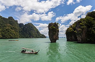
Khao Phing Kan or Ko Khao Phing Kan, commonly known in English as James Bond Island, is an island in Thailand, in Phang Nga Bay northeast of Phuket. About 40 metres (130 ft) from the shores of Khao Phing Kan lies a 20-metre (66 ft) tall islet called Ko Ta Pu or Ko Tapu.

The Malaysian plover is a small wader that nests on beaches and salt flats in Southeast Asia.

Ko Sai is one of the gulf islands of Thailand. It lies on the west side of the Gulf of Thailand, about 2 km off-shore.

Ko Nom Sao are twin islands in Phang Nga Bay, and are part of the Ko Panyi (เกาะปันหยี) subdistrict (tambon), Phang Nga Province, Thailand.

Prachuap Bay is a bay in the west side of the Gulf of Siam or Gulf of Thailand. It lies off Prachuap Khiri Khan town, Prachuap Khiri Khan Province.

Prachuap Khiri Khan Province Stadium is a multi-purpose stadium in Prachuap Khiri Khan Province, Thailand. It is currently used mostly for football matches and is the home stadium of Prachuap F.C. The stadium holds 5,000 people.

Suan Son Pradiphat is a sand beach in Tambon Nong Kae, Hua Hin District, Prachuap Khiri Khan Province, Thailand. Suan Son Pradiphat is regarded as another popular and well-known marine attraction in Hua Hin, it is about 9 km south of town of Hua Hin. Khao Takiab hill bisected between these two areas.

Hat Wanakon National Park is a sand beach and marine national park in Prachuap Khiri Khan Province, western Thailand. It overlaps two districts of Prachuap Khiri Khan: Mueang Prachuap Khriri Khan and Thap Sakae, with an area of 23,750 rai ~ 38 square kilometres (15 sq mi). The beach is on Petchkasem Road about 23 km from Prachuap Khiri Khan town towards Thap Sakae, about 300 km from Bangkok.

Namtok Huai Yang National Park is a national park in Thailand, consisting of several waterfalls and forests on the mountain range bordering Thailand and Myanmar.

Bang Boet is a coastal area of the Gulf of Thailand belonging to Sai Thong Sub-district, Bang Saphan Noi District of Prachuap Khiri Khan Province and Pak Khlong Sub-district, Pathio District of Chumphon province.
Ao Siam National Park is a national park that is preparing to reopen in Thailand. It is an area on the western coast of the Gulf of Thailand covering the Pa Klang Ao Forest Park, Mae Ramphueng Forest Park, Koh Talu, Koh Sing, and Koh Sanghk, Bang Saphan District Prachuap Khiri Khan Province. Which the three islands are 8 kilometers from the coast, 6 kilometers, and 5 kilometers, respectively. There are also some areas located in the drafting area of the Ministry of Natural Resources and Environment (Thailand) regarding environmental protection measures in some areas of Thap Sakae District, Kui Buri District, Sam Roi Yot District, Mueang Prachuap Khiri Khan District, Bang Saphan District, and Bang Saphan Noi District Prachuap Khiri Khan Province.