Aorangi railway station

Last updated

Aorangi railway station
Aorangi in 1967.jpg
Aorangi in 1967, showing the bridge over the Oroua, meat works, sidings and possible site of station shelter
General information
LocationNew Zealand
Coordinates 40°14′36″S175°35′06″E / 40.243305°S 175.585032°E / -40.243305; 175.585032
Elevation70 m (230 ft)
Owned by KiwiRail
Line(s) North Island Main Trunk
Distance Wellington 150.9 km (93.8 mi)
Platforms1
History
Opened1 October 1876 (1876-10-01)
Closed2 November 1987 (1987-11-02)
Electrified25 kV 50 Hz AC June 1988
Services
Preceding station Historical railways Following station
Feilding
Line open,
station closed
2.05 km (1.27 mi)
  North Island Main Trunk
KiwiRail
  Taonui
Line open,
station closed
3.17 km (1.97 mi)

Aorangi railway station was a small station on the North Island Main Trunk in New Zealand. [1] [2]

Contents

The station was opened in 1878; and closed on 10 August 1959 for passengers and 2 November 1987 for goods traffic. [3] There is now only a single line through the station site. [4] Te Araroa long distance walkway passes the station site. [5]

History

By July 1876 the rails were in place, linking Palmerston North and Feilding, [6] and ballasting was finished in September. [7] The formal opening of the railway was on 19 October 1876. [8] Charles Bull had a sawmill at Aorangi until about 1886. [9] It had a private siding 4 chains (260 ft; 80 m) on the Feilding side of Aorangi from 1878, [10] but there was a complaint about trains not stopping for passengers in 1883. [11] By 1896 there was a shelter shed and passenger platform and also a cart approach by 1911. [10]

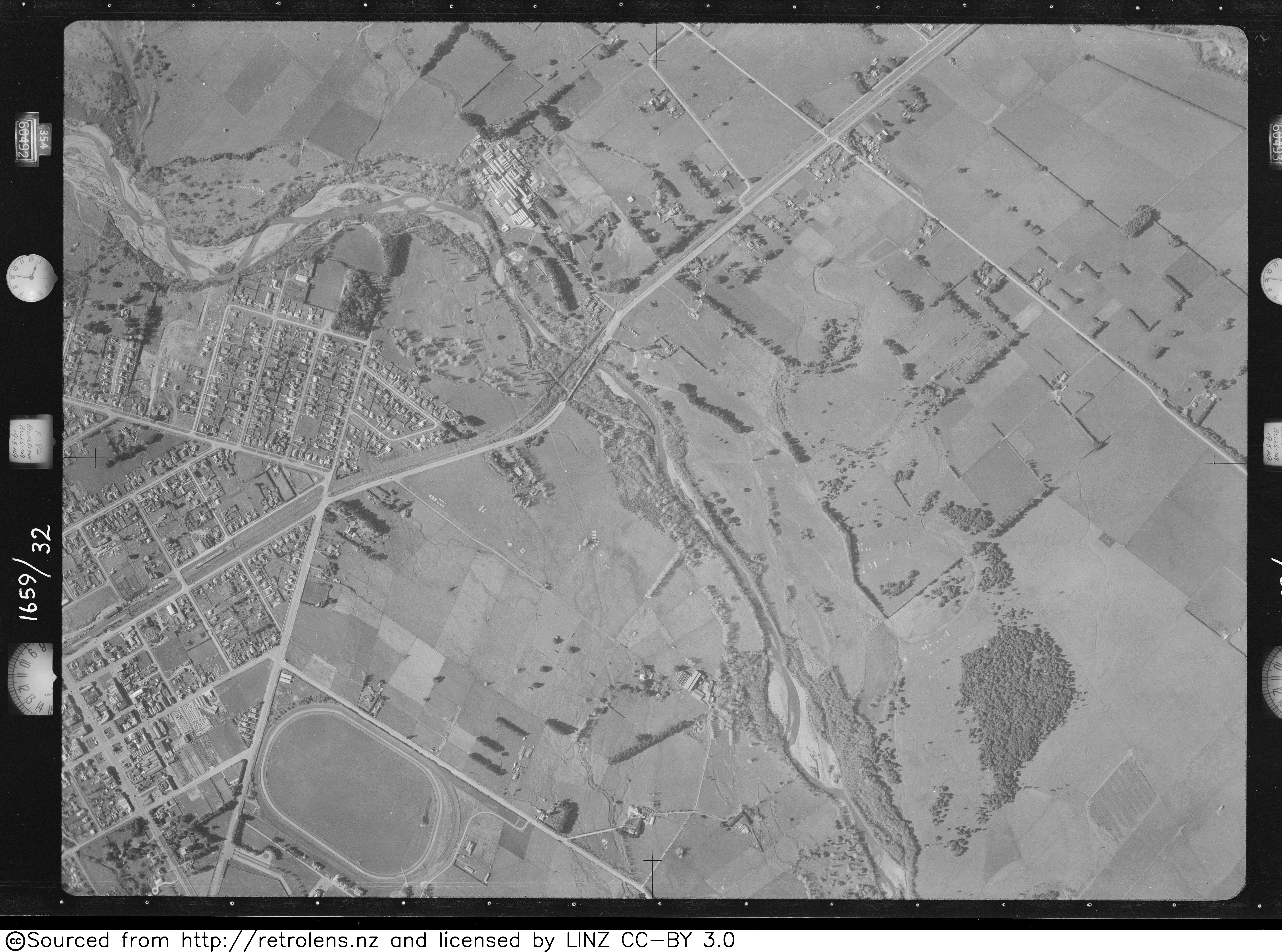
By 1959 there was still a shelter, platform and Borthwicks' private siding, which was the only source of local rail traffic after closure of the station on 10 August 1959. [10] A 1949 aerial photo seems to show a shelter, [12] where the 1967 photo (to the right) shows a white mark at the foot of the photo. In 1989 there was still a passing loop and private siding. [10]

Aorangi Bridge

The railway crosses the Oroua River between Aorangi and Feilding [13] on Aorangi Bridge, which was rebuilt in 1930 [14] -31, [15] when the curve was eased from a radius of 14 chains (920 ft; 280 m) to 20 ch (1,300 ft; 400 m). It has ten 20 ch (1,300 ft; 400 m)60 feet (18 m) spans, [16] with a total length of 183 m (600 ft). [17]

A footbridge over the river was built in 1883. [18] The first road bridge opened on 21 March 1893. [19] It was replaced by a ferro-concrete bridge in 1930. [20]

The road and railway bridges were partly swept away in a flood on 17 April 1897. [21]

Freezing works

A siding for the Oroua Freezing works was put in during its construction in 1915. [22] West Coast Meat & Produce Co Ltd had the works formally opened by Prime Minister, Bill Massey, on 17 April 1916. [23] Later that year the company changed its name to Feilding Farmers’ Freezing Company Ltd. [24] They sold the works to Thomas Borthwick and Sons (Australasia) Ltd in 1931, [25] who had a small shunting locomotive at Aorangi from 1931 to 1973. [26] Rail traffic was reduced in 1944 by allowing road haulage for up to 20 mi (32 km) parallel with the railway. [27] The works became part of AFFCO [28] from May 1992, after re-building in September 1991. [29] The works is no longer rail connected. [30]

Related Research Articles

<span class="mw-page-title-main">Linton railway station, Palmerston North</span> Defunct railway station in New Zealand

Linton railway station was a flag station at Linton in Palmerston North on the North Island Main Trunk in New Zealand.

<span class="mw-page-title-main">Longburn railway station</span> Defunct railway station in New Zealand

Longburn railway station was a station in Longburn, on the North Island Main Trunk in New Zealand. The platform, which is across from the Fonterra Factory, remains but the structure has been demolished.

<span class="mw-page-title-main">Awapuni railway station</span> Defunct railway station in New Zealand

Awapuni railway station was a station in Kairanga County, on the Foxton Branch and, from 1908, the North Island Main Trunk in New Zealand, now in the Palmerston North suburb of Awapuni. It was beside the Mangaone Stream, near its confluence with the Kawau Stream, about 400 m (440 yd) west of Maxwells Line on the north side of Pioneer Highway. Nothing remains of the former station, except a wide verge, partly occupied by a cycleway, built in 2015.

<span class="mw-page-title-main">Greatford railway station</span> Defunct railway station in New Zealand

Greatford railway station was a station on the North Island Main Trunk (NIMT) in New Zealand, south of Marton. It is in the Manawatū-Whanganui region. Only a substation and a passing loop remain.

<span class="mw-page-title-main">Kakariki railway station</span> Defunct railway station in New Zealand

Kakariki railway station was a station on the North Island Main Trunk and in the Manawatū-Whanganui region of New Zealand.

<span class="mw-page-title-main">Taonui railway station</span> Defunct railway station in New Zealand

Taonui railway station was a station on the North Island Main Trunk and in the Manawatū-Whanganui region of New Zealand. From 1879 to 1886 it was the junction for the Taonui Branch. A passing loop remains at the station site.

<span class="mw-page-title-main">Bunnythorpe railway station</span> Defunct railway station in New Zealand

Bunnythorpe railway station was a station on the North Island Main Trunk in New Zealand, serving the village of Bunnythorpe.

<span class="mw-page-title-main">Utiku railway station</span> Defunct railway station in New Zealand

Utiku railway station was a station on the North Island Main Trunk in New Zealand, and in the Manawatū-Whanganui region. It opened in 1904 and closed in 1986. It was part of the 13+12 mi (21.7 km) Mangaweka to Taihape section, officially opened by the Prime Minister, Richard Seddon, on 21 November 1904. It closed in 1986. A passing loop remains.

<span class="mw-page-title-main">Winiata railway station</span> Railway station in New Zealand

Winiata railway station was a station on the North Island Main Trunk in New Zealand. It was decorated with an archway when the 13+12 mi (21.7 km) Mangaweka to Taihape section was opened by the Prime Minister, Richard Seddon, on 21 November 1904.

<span class="mw-page-title-main">Cliff Road railway station</span> Railway station in New Zealand

Cliff Road railway station was a flag station on the North Island Main Trunk in New Zealand. It opened in 1888 and closed in 1982. Only a single track now passes through the station site and no buildings remain.

<span class="mw-page-title-main">Ohakune railway station</span> Railway station in New Zealand

Ohakune railway station is a station on the North Island Main Trunk (NIMT), which serves the town of Ohakune in the Manawatū-Whanganui region of New Zealand. It is served by KiwiRail's Northern Explorer long distance train between Wellington and Auckland. It was called Ohakune Junction from 10 August 1926 until Raetihi Branch closed in 1968, to avoid confusion with Ohakune Town station on that branch. It was the second highest operating railway station in New Zealand, after National Park.

<span class="mw-page-title-main">Feilding railway station</span> Railway station in Feilding, New Zealand

Feilding railway station was a station on the North Island Main Trunk line in Feilding, New Zealand. It was opened on 1 October 1876 and closed on 25 June 2012. The station is now used by Feilding Information Centre and an occasional excursion train.

<span class="mw-page-title-main">Marton railway station, Manawatū-Whanganui</span> Railway station in New Zealand

Marton railway station was a station and rail junction on the Marton–New Plymouth Line, opened on 4 February 1878. After the North Island Main Trunk (NIMT) made a junction to the south of Marton, a new station was built there and the old station renamed and downgraded, in 1898.

<span class="mw-page-title-main">Ormondville</span> Settlement in Manawatū-Whanganui Region, New Zealand

Ormondville is a locality in the Manawatū-Whanganui region of New Zealand's North Island. It is located inland, south of Waipukurau and west of Flemington, Hawke's Bay.

<span class="mw-page-title-main">Taringamotu railway station</span> Former railway station in New Zealand

Taringamotu railway station was a station at Taringamotu on the North Island Main Trunk, in the Ruapehu District and Manawatū-Whanganui region.

<span class="mw-page-title-main">Pokaka railway station</span> Railway station in New Zealand

Pokaka was a station on the North Island Main Trunk line, in the Ruapehu District of New Zealand. It served the small village of Pokaka and lay to the south of Makatote Viaduct, the late completion of which held up opening of the station.

<span class="mw-page-title-main">Erua railway station</span> Railway station in New Zealand

Erua was a station on the North Island Main Trunk line, in the Ruapehu District of New Zealand. It served the small village of Erua. For a month in 1908 it was the terminus of the line from Auckland. Makatote Viaduct and tramway are about 3 mi (4.8 km) south of Erua.

<span class="mw-page-title-main">Matamau</span> Place in Manawatū-Whanganui, New Zealand

Matamau is a small village, on a ridge between the Matamau and Whakaruatapu Streams, tributaries of the Manawatū River, in the Manawatū-Whanganui region of New Zealand's North Island. State Highway 2 and the Palmerston North–Gisborne line run through the village. It has a rare surviving example of a basic railway station, a cafe, developed from the former post office and store about 1969, and a truck repair workshop. Until the 1870s it was densely forested, but most of the trees were felled and milled by 1910 and replaced by farms.

<span class="mw-page-title-main">Makotuku</span> Place in Manawatū-Whanganui, New Zealand

Makotuku is a locality in the Manawatu-Whanganui Region of New Zealand's North Island, about 3 km2 (1.2 sq mi) west of Ormondville.

<span class="mw-page-title-main">Piripiri, Manawatū-Whanganui</span> Place in Manawatū-Whanganui, New Zealand

Piripiri is a sparsely populated area in the Manawatū-Whanganui region, on State Highway 2 and the Palmerston North–Gisborne line. It is 3 mi 8 ch (5.0 km) north of Dannevirke, and has 150 people scattered over a meshblock of 21.8 km2 (8.4 sq mi).

References

  1. New Zealand Railway and Tramway Atlas (First ed.). Quail Map Co. 1965. pp. 3 & 4.
  2. Pierre, Bill (1981). North Island Main Trunk. Wellington: A.H&A.W Reed. pp. 289–290. ISBN   0589013165.
  3. Scoble, Juliet (2012). Names & Opening & Closing Dates of Railway Stations in New Zealand.
  4. "Te Araroa Trail". Google Maps. Retrieved 4 March 2021.
  5. "Feilding to Palmerston North — NZ Walking Access Commission Ara Hīkoi Aotearoa". www.walkingaccess.govt.nz. Retrieved 7 March 2021.
  6. "PUBLIC WORKS STATEMENT, BY THE MINISTER FOR PUBLIC WORKS, THE HON. EDWARD RICHARDSON". paperspast.natlib.govt.nz. 25 July 1876. Retrieved 21 January 2021.
  7. "THE FIELDING SETTLEMENT (REPORT ON THE PROGRESS AND PRESENT CONDITION OF). APPENDIX TO THE JOURNALS OF THE HOUSE OF REPRESENTATIVES, 1877". paperspast.natlib.govt.nz. Retrieved 21 January 2021.
  8. "LOCAL AND GENERAL. WANGANUI CHRONICLE". paperspast.natlib.govt.nz. 20 October 1876. Retrieved 5 March 2021.
  9. "Local and General News FEILDING STAR". paperspast.natlib.govt.nz. 14 October 1886. Retrieved 6 March 2021.
  10. 1 2 3 4 "Stations" (PDF). NZR Rolling Stock Lists. Archived from the original (PDF) on 8 February 2013. Retrieved 10 August 2020.
  11. "LOCAL AND GENERAL. FEILDING STAR". paperspast.natlib.govt.nz. 7 April 1883. Retrieved 5 March 2021.
  12. "Retrolens Survey Number: SN543 Photo Number: 32". 23 May 1949.
  13. "Oroua River, Manawatu-Wanganui". NZ Topo Map. Retrieved 20 January 2021.
  14. "A Reconstructed Railway Bridge — Views of the new railway bridge recently constructed over the Oroua River (on the Auckland-Wellington Main Trunk Line, between Wellington and Marton), and of the men who carried out the work | NZETC". nzetc.victoria.ac.nz. Retrieved 20 January 2021.
  15. "LOCAL AND GENERAL. MANAWATU HERALD". paperspast.natlib.govt.nz. 17 March 1931. Retrieved 21 January 2021.
  16. "NEW RAILWAY BRIDGE. MANAWATU STANDARD". paperspast.natlib.govt.nz. 28 August 1929. Retrieved 21 January 2021.
  17. New Zealand Railway and Tramway Atlas (First ed.). Quail Map Co. 1965. pp. 3 & 4.
  18. "Our Feilding Letter. MANAWATU TIMES". paperspast.natlib.govt.nz. 17 September 1883. Retrieved 5 March 2021.
  19. "Opening of the Aorangi Bridge FEILDING STAR". paperspast.natlib.govt.nz. 23 March 1893. Retrieved 5 March 2021.
  20. "MANAWATU HERALD". paperspast.natlib.govt.nz. 1 March 1930. Retrieved 5 March 2021.
  21. "Oroua River flood - 1897 37-12". www.feildingheritage.nz. Retrieved 5 March 2021.
  22. "OROUA FREEZING WORKS. FEILDING STAR". paperspast.natlib.govt.nz. 9 April 1915. Retrieved 5 March 2021.
  23. "Oroua Freezing Works. MANAWATU TIMES". paperspast.natlib.govt.nz. 17 April 1916. Retrieved 5 March 2021.
  24. "Feilding Farmers' Freezing Company. MANAWATU TIMES". paperspast.natlib.govt.nz. 13 September 1916. Retrieved 5 March 2021.
  25. "FEILDING FREEZING WORKS. MANAWATU STANDARD". paperspast.natlib.govt.nz. 3 September 1931. Retrieved 5 March 2021.
  26. "New Zealand Rolling Stock Register - Internal Combustion section". www.nzrsr.co.nz. Retrieved 5 March 2021.
  27. "CARTAGE OF FAT LAMBS. MANAWATU STANDARD". paperspast.natlib.govt.nz. 26 December 1944. Retrieved 5 March 2021.
  28. "AFFCO Manawatu MBP". www.affco.co.nz. Retrieved 5 March 2021.
  29. "Meat Processing Plant Discharge Consents Application and Assessment of Environmental Effects" (PDF). March 2015.
  30. "Basemaps | Land Information New Zealand". basemaps.linz.govt.nz. Retrieved 5 March 2021.