
The Apalachicola River is a river, approximately 160 mi (180 km) long in the state of Florida. The river's large watershed, known as the ACF River Basin, drains an area of approximately 19,500 square miles (50,500 km2) into the Gulf of Mexico. The distance to its farthest head waters in northeast Georgia is approximately 500 miles (800 km). Its name comes from the Apalachicola people, who used to live along the river. It is the largest river in Florida.
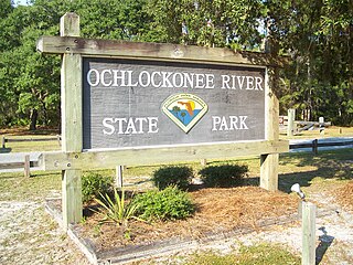
Ochlockonee River State Park is a Florida State Park located in Wakulla County, Florida, south of the town of Sopchoppy in the Florida Panhandle. Located off of U.S. 319 on the Ochlockonee River, just north of the Gulf of Mexico coast, it is surrounded by the Apalachicola National Forest and the St. Marks National Wildlife Refuge and provides important habitat for the endangered red-cockaded woodpecker.

Torreya State Park is a 13,735 acre (56 km²) Florida State Park, United States National Natural Landmark and historic site thirteen miles (19 km) north of Bristol. It is located north of S.R 12 on the Apalachicola River, in northwestern Florida, at 2576 N.W. Torreya Park Road.

The Arthur R. Marshall Loxahatchee National Wildlife Refuge is a 145,188-acre (587.55 km2) wildlife sanctuary is located west of Boynton Beach, in Palm Beach County, Florida. It is also known as Water Conservation Area 1 (WCA-1). It includes the most northern remnant of the historic Everglades wetland ecosystem.

The Indian River Lagoon is a grouping of three lagoons: the Mosquito Lagoon, the Banana River, and the Indian River, on the Atlantic Coast of Florida; one of the most biodiverse estuaries in the Northern Hemisphere and is home to more than 4,300 species of plants and animals.

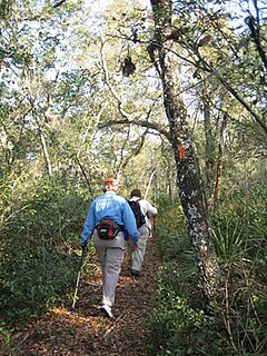
The Apalachicola National Forest is the largest U.S. National Forest in the state of Florida. It encompasses 632,890 acres and is the only national forest located in the Florida Panhandle. The National Forest provides water and land-based outdoors activities such as off-road biking, hiking, swimming, boating, hunting, fishing, horse-back riding, and off-road ATV usage.

De Soto National Forest, named for 16th-century Spanish explorer Hernando de Soto, is 518,587 acres of pine forests in southern Mississippi. It is one of the most important protected areas for the biological diversity of the Gulf Coast ecoregion of North America.

The John Heinz National Wildlife Refuge at Tinicum is a 1000-acre (4.05 km2) National Wildlife Refuge in Philadelphia and Tinicum Township, Delaware County, in Pennsylvania. Adjacent to the Philadelphia International Airport, the refuge serves to protect the largest remaining freshwater tidal marsh in Pennsylvania. Established in 1972 as the Tinicum National Environmental Center, it was renamed in 1991 after the late H. John Heinz III who had helped preserve Tinicum Marsh.
The Florida Trail is one of eleven National Scenic Trails in the United States. It currently runs 1,000 miles (1,600 km), with 300 miles (480 km) planned, from Big Cypress National Preserve to Fort Pickens at Gulf Islands National Seashore, Pensacola Beach. Also known as the Florida National Scenic Trail, the Florida Trail provides permanent non-motorized recreation opportunity for hiking and other compatible activities and is within an hour of most Floridians. The Florida National Scenic Trail is designated as a National Scenic Trail by the National Trails System Act of 1968.
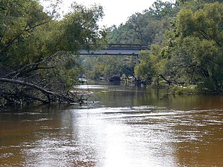
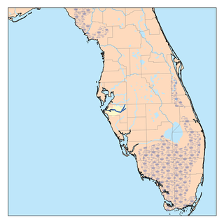
The Ochlockonee River is a fast running river, except where it has been dammed to form Lake Talquin in Florida, originating in Georgia and flowing for 206 miles (332 km) before terminating in Florida.
The Manatee River is a 36-mile-long (58 km) river in Manatee County, Florida. The river forms in the northeastern corner of Manatee County and flows into the Gulf of Mexico at the southern edge of Tampa Bay.

Elkhorn Slough is a 7-mile-long (11 km) tidal slough and estuary on Monterey Bay in Monterey County, California. It is California's second largest estuary and the United States' first estuarine sanctuary. The community of Moss Landing and the Moss Landing Power Plant are located at the mouth of the slough on the bay.

The Florida black bear is a subspecies of the American black bear that has historically ranged throughout most of Florida and the southern portions of Georgia, Alabama, and Mississippi. The large black-furred bears live mainly in forested areas and have seen recent habitat reduction throughout the state due to increased human development, as well as habitat modifications within bear habitat.

Chassahowitzka Wildlife Management Area (WMA) preserves 24,243 acres of sandhill, mesic hammock, and forested wetland habitat ten miles north of Weeki Wachee in Hernando County, Florida. The area consists of one large tract of land, with three satellite tracts nearby.

Fred C. Babcock/Cecil M. Webb Wildlife Management Area (WMA) is Florida's oldest Wildlife Management Area and protects 80,772 acres just south and east of Punta Gorda in Charlotte and Lee Counties, Florida. The area is accessed from its own exit off of Interstate-75.

Escribano Point Wildlife Management Area (EPWMA) contains 4,057 acres of salt marsh, shrub bog, and sandhill habitat fourteen miles north of Pensacola in Santa Rosa County, Florida. In 2004, an initial 1,166 acres were acquired by the Florida Forever program and leased to the Florida Fish and Wildlife Conservation Commission to establish the EPWMA.
Apalachee Wildlife Management Area (WMA) consists of 7,952 acres of upland longleaf pine and wetland habitat three miles north of Sneads in Jackson County, Florida. The area is broken up into three management zones, all located along Lake Seminole and the Chattahoochee River.
Suwannee Ridge Wildlife and Environmental Area (WEA) conserves 1,428 acres of longleaf pine uplands, karst topography and hardwood hammocks ten miles southwest of Jasper in Hamilton County, Florida.
Fort White Wildlife and Environmental Area (WEA) protects 1,610 acres of primarily sandhill habitat four miles west of Fort White in Gilchrist County, Florida.

Aucilla Wildlife Management Area conserves 50,549 acres of hydric hammock, mesic flatwoods, upland forest, and spring-run river twelve miles southeast of Tallahassee in Jefferson and Taylor Counties in Florida.


