Canada has a vast geography that occupies much of the continent of North America, sharing a land border with the contiguous United States to the south and the U.S. state of Alaska to the northwest. Canada stretches from the Atlantic Ocean in the east to the Pacific Ocean in the west; to the north lies the Arctic Ocean. Greenland is to the northeast with a shared border on Hans Island. To the southeast Canada shares a maritime boundary with France's overseas collectivity of Saint Pierre and Miquelon, the last vestige of New France. By total area, Canada is the second-largest country in the world, after Russia. By land area alone, however, Canada ranks fourth, the difference being due to it having the world's largest proportion of fresh water lakes. Of Canada's thirteen provinces and territories, only two are landlocked while the other eleven all directly border one of three oceans.

The Rocky Mountains, also known as the Rockies, are a major mountain range and the largest mountain system in North America. The Rocky Mountains stretch 3,000 miles in straight-line distance from the northernmost part of western Canada, to New Mexico in the southwestern United States. Depending on differing definitions between Canada and the U.S., its northern terminus is located either in northern British Columbia's Terminal Range south of the Liard River and east of the Trench, or in the northeastern foothills of the Brooks Range/British Mountains that face the Beaufort Sea coasts between the Canning River and the Firth River across the Alaska-Yukon border. Its southernmost point is near the Albuquerque area adjacent to the Rio Grande rift and north of the Sandia–Manzano Mountain Range. Being the easternmost portion of the North American Cordillera, the Rockies are distinct from the tectonically younger Cascade Range and Sierra Nevada, which both lie farther to its west.

The Continental Divide of the Americas is the principal, and largely mountainous, hydrological divide of the Americas. The Continental Divide extends from the Bering Strait to the Strait of Magellan, and separates the watersheds that drain into the Pacific Ocean from those river systems that drain into the Atlantic and Arctic Ocean, including those that drain into the Gulf of Mexico, the Caribbean Sea, and Hudson Bay.

The Brooks Range is a mountain range in far northern North America stretching some 700 miles (1,100 km) from west to east across northern Alaska into Canada's Yukon Territory. Reaching a peak elevation of 8,976 feet (2,736 m) on Mount Isto, the range is believed to be approximately 126 million years old.

The Pacific Coast Ranges are the series of mountain ranges that stretch along the West Coast of North America from Alaska south to Northern and Central Mexico. Although they are commonly thought to be the westernmost mountain range of the continental United States and Canada, the geologically distinct Insular Mountains of Vancouver Island lie farther west.

The Alaska Range is a relatively narrow, 600-mile-long (950 km) mountain range in the southcentral region of the U.S. state of Alaska, from Lake Clark at its southwest end to the White River in Canada's Yukon Territory in the southeast. Denali, the highest mountain in North America, is in the Alaska Range. The range is part of the American Cordillera.

The Canadian Rockies or Canadian Rocky Mountains, comprising both the Alberta Rockies and the British Columbian Rockies, is the Canadian segment of the North American Rocky Mountains. It is the easternmost part of the Canadian Cordillera, which is the northern segment of the North American Cordillera, the expansive system of interconnected mountain ranges between the Interior Plains and the Pacific Coast that runs northwest–southeast from central Alaska to the Isthmus of Tehuantepec in Mexico.

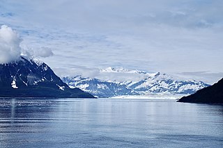
The Saint Elias Mountains are a subgroup of the Pacific Coast Ranges, located in southeastern Alaska in the United States, Southwestern Yukon and the very far northwestern part of British Columbia in Canada. The range spans Wrangell-St. Elias National Park and Preserve in the United States and Kluane National Park and Reserve in Canada and includes all of Glacier Bay National Park in Alaska. In Alaska, the range includes parts of the city/borough of Yakutat and the Hoonah-Angoon and Valdez-Cordova census areas.

Mount Hubbard is one of the major mountains of the Saint Elias Range. It is located on the Alaska/Yukon border; the Canadian side is within Kluane National Park and Reserve, and the American side is part of Wrangell–St. Elias National Park. The mountain was named in 1890 by U.S. Geological Survey geologist Israel Russell after Gardiner Greene Hubbard, first president of the National Geographic Society, which had co-sponsored Russell's expedition.

The Purcell Mountains are a mountain range in southeastern British Columbia, Canada. They are a subrange of the Columbia Mountains, which includes the Selkirk, Monashee, and Cariboo Mountains. They are located on the west side of the Rocky Mountain Trench in the area of the Columbia Valley, and on the east side of the valley of Kootenay Lake and the Duncan River. The only large settlements in the mountains are the Panorama Ski Resort and Kicking Horse Resort, adjacent to the Columbia Valley towns of Invermere and Golden, though there are small settlements, such as Yahk and Moyie along the Crowsnest Highway, and residential rural areas dependent on the cities of Creston, Kimberley and Cranbrook, which are located adjacent to the range.
The Pacific Cordillera, also known as the Western Cordillera or simply The Cordillera, is a top-level physiographic region of Canada, referring mainly to the extensive cordillera system in Western and Northwestern Canada that constitutes the northern part of the North American Cordillera. The mountain ranges in this region were covered during the Pleistocene by the Cordilleran Ice Sheet, the extent of which gives perspective on the geographic extent of this region. The cordillera extends from the Alaska's Brooks and Alaska Ranges, southeast through most of the Yukon and British Columbia as well as the southwestern fringe of Northwest Territories and Alberta, to stretch its margin beyond the Canada–United States border with five extensive lobes reaching into the mountain valleys of Montana and Washington.

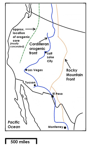
The North American Cordillera, sometimes also called the Western Cordillera of North America, the Western Cordillera or the Pacific Cordillera, is the North American portion of the American Cordillera, the mountain chain system (cordillera) along the western coast of the Americas. The North American Cordillera covers an extensive area of mountain ranges, intermontane basins and plateaus in Western/Northwestern Canada, Western United States and Mexico, including much of the territory west of the Great Plains.

The Rocky Mountain Front is a somewhat unified geologic and ecosystem area in North America where the eastern slopes of the Rocky Mountains meet the plains. In 1983, the Bureau of Land Management called the Rocky Mountain Front "a nationally significant area because of its high wildlife, recreation, and scenic values". Conservationists Gregory Neudecker, Alison Duvall, and James Stutzman have described the Rocky Mountain Front as an area that warrants "the highest of conservation priorities" because it is largely unaltered by development and contains "unparalleled" numbers of wildlife.

Heart Peaks, originally known as the Heart Mountains, is a mountain massif in the Northern Interior of British Columbia, Canada. It is 90 km (56 mi) northwest of the small community of Telegraph Creek and just southwest of Callison Ranch. With a maximum elevation of 2,012 m (6,601 ft), it rises above the surrounding landscape on the Nahlin Plateau, which is part of the western Stikine Plateau. Heart Peaks has been an area of prospecting since the 1980s with the discovery of precious metals.

Alfred Hulse Brooks was an American geologist who served as chief geologist for Alaska for the United States Geological Survey from 1903 to 1924. He is credited with discovering that the biggest mountain range in Arctic Alaska, now called the Brooks Range, was separate from the Rocky Mountains. He also took many photographs of local communities. A collection of the images is held at Yale University.

The Volcano, also known as Lava Fork volcano, is a small cinder cone in the Boundary Ranges of the Coast Mountains in northwestern British Columbia, Canada. It is located approximately 60 km (40 mi) northwest of the small community of Stewart near the head of Lava Fork. With a summit elevation of 1,656 m (5,433 ft) and a topographic prominence of 311 m (1,020 ft), it rises above the surrounding rugged landscape on a remote mountain ridge that represents the northern flank of a glaciated U-shaped valley.

Mount Bayard is a 1,999-metre (6,558 ft) glaciated mountain located in the Boundary Ranges on the international boundary line of Alaska and British Columbia. It is situated 22 kilometres (14 mi) north-northwest of Stewart, 10 km (6 mi) southeast of Mount White-Fraser, and 3.4 km (2 mi) east of Mount Lindeborg, which is its nearest higher peak. Precipitation runoff from the peak and meltwater from the Boundary and Salmon Glaciers that surround the peak drains into the Salmon River. Weather permitting, the mountain can be seen from the gravel Granduc Mine Road at Hyder, Alaska.

Mount Forde, also known as Boundary Peak 161, is a 6,883-foot (2,098 m) mountain summit located in the Fairweather Range of the Saint Elias Mountains, on the Canada–United States border between southeast Alaska and British Columbia. The peak is situated on the boundary of Glacier Bay National Park and Preserve, near the head of Tarr Inlet, 109 mi (175 km) northwest of Juneau, and 4.4 mi (7 km) northeast of Mount Turner, which is the nearest higher peak. Although modest in elevation, relief is significant since the mountain rises up from tidewater in less than four miles.


