| Arak gorges | |
|---|---|
 | |
 Arak gorges | |
| Geography | |
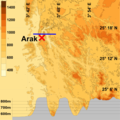
| Coordinates | 25°17′23″N3°44′39″E / 25.28972°N 3.74417°E |
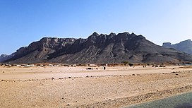
The Arak gorges are a series of desert gorges located in Tamanrasset Province, Algeria. [1] The gorges are roughly 330 kilometres from the city of Tamanrasset. Carved by ancient river activity, the canyon walls vary in height from 250 to 500 m (800 to 1600 ft), and the canyon base is now a dry wadi. [2]
Despite the extremely dry climate (only 60 to 75 mm of rain per year), hardy desert plants and animals survive in the gorges. Examples include the red-headed rock agama, wheatear birds, and small vultures. [2] There are no permanent human settlements in the gorges, though stone tools and burial mounds indicate the occasional human presence throughout history. [2]