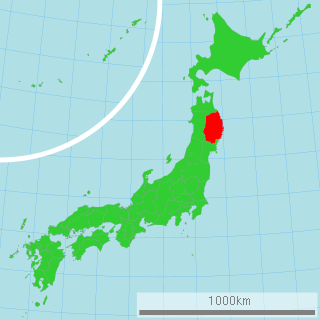
Iwate Prefecture is a prefecture in the Tōhoku region of Japan. Located on the main island of Honshu, it contains the island's easternmost point. The capital is Morioka. Iwate has the lowest population density of any prefecture outside Hokkaido. Famous attractions include the Buddhist temples of Hiraizumi, including Chūson-ji and Mōtsū-ji with their treasures, Fujiwara no Sato, a movie lot and theme park in Esashi Ward, Oshu City, Tenshochi, a park in Kitakami City known for its big, old cherry trees and Morioka Castle in Morioka City.

The Tōhoku region, Northeast region, or Northeast Japan consists of the northeastern portion of Honshu, the largest island of Japan. This traditional region consists of six prefectures (ken): Akita, Aomori, Fukushima, Iwate, Miyagi, and Yamagata.

Motoyoshi is a rural district in Miyagi Prefecture, in the Tōhoku region of northern Japan.

The 2005 Miyagi earthquake struck the east coast of the Japanese island of Honshū at 11.46 am on August 16, causing casualties, building collapses and power outages. The event registered 7.2 on the moment magnitude scale.
The seismicity of the Sanriku coast identifies and describes the seismic activity of an area of Japan. Seismicity refers to the frequency, type and size of earthquakes experienced over a period of time. The Sanriku coast is a descriptive term referring to the coastal areas of the former provinces of Rikuō in Aomori, Rikuchū in Aomori, and Rikuzen in Miyagi.

On June 14, the 2008 Iwate earthquake struck the Tōhoku region of northeastern Honshū in Japan. Japan Meteorological Agency (JMA) officially named this earthquake the Iwate–Miyagi Nairiku earthquake in 2008.
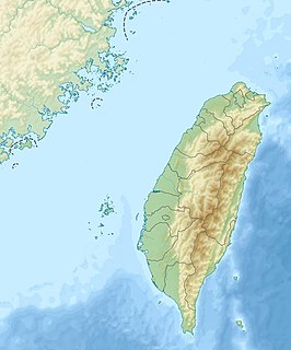
The 1941 Chungpu earthquake occurred with a magnitude of 7.1 on December 17, and was centred on the town of Chūho Village, Kagi District, Tainan Prefecture of Taiwan under Japanese rule. It was the fourth-deadliest earthquake of the 20th century in Taiwan, claiming 358 lives.
The 1978 Miyagi earthquake occurred at 17:14 local time on 12 June. It had a surface wave magnitude of 7.7, JMA magnitude 7.4, and triggered a small tsunami. The earthquake reached a maximum intensity of Shindo 5 in Sendai and caused 28 deaths and 1,325 injuries.
The 1984 Otaki earthquake hit Nagano Prefecture, Japan on September 14, 1984, at 08:48 local time. Registering a magnitude of Ms 6.3, the earthquake destroyed Otaki, and triggered major landslides. The earthquake left at least 29 people dead or missing, making it the deadliest earthquake in 1984.
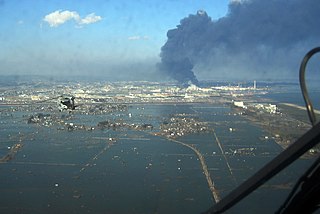
The 2011 earthquake off the Pacific coast of Tōhoku was a magnitude 9.0–9.1 (Mw) undersea megathrust earthquake off the coast of Japan that occurred at 14:46 JST on Friday 11 March 2011, with the epicentre approximately 70 kilometres (43 mi) east of the Oshika Peninsula of Tōhoku and the hypocenter at an underwater depth of approximately 29 km (18 mi). The earthquake is often referred to in Japan as the Great East Japan Earthquake and is also known as the 2011 Tōhoku earthquake, and the 3.11 earthquake.
The April 2011 Miyagi earthquake occurred off the coast of Miyagi Prefecture, approximately 66 kilometres (41 mi) east of Sendai, Japan. The Mw 7.1 thrust earthquake was classified as an aftershock of the March 11 Tōhoku earthquake, and occurred at 23:32 JST (14:32 UTC) on Thursday, 7 April 2011.
The April 2011 Fukushima earthquake was a potent magnitude 6.6 Mw intraplate aftershock that occurred at 17:16 JST (08:16 UTC) on 11 April, in the Hamadōri region of Fukushima, Japan. With a shallow focus of 13 km (8.1 mi), the earthquake was centred inland about 36 km (22 mi) west of Iwaki, causing widespread strong to locally severe shaking. It was one of many aftershocks to follow the 11 March Tōhoku earthquake, and the strongest to have its epicentre located inland.
The 1936 Miyagi earthquake occurred on November 3 at 05:45 local time with a magnitude Ms 7.2, or MJMA 7.4. The epicenter was located off the Miyagi Prefecture, Japan. Four people were injured. Building damage was reported. In Isobe (磯部) village, nowadays part of Sōma, Fukushima, a small market building collapsed. A tsunami was recorded.
Nyūdō-bōzu are yōkai first known in Tsukude, Minamishitara District, Aichi Prefecture, and then also in Fukushima Prefecture; Kurikoma, Kurihara District, Miyagi Prefecture ; Hirano, Suwa District, Nagano Prefecture, among other places.

Miyagi Prefecture is a prefecture in the Tōhoku region of Japan. The capital is Sendai.

The 2016 Kumamoto earthquakes are a series of earthquakes, including a magnitude 7.0 mainshock which struck at 01:25 JST on April 16, 2016 beneath Kumamoto City of Kumamoto Prefecture in Kyushu Region, Japan, at a depth of about 10 kilometres (6.2 mi), and a foreshock earthquake with a magnitude 6.2 at 21:26 JST (12:26 UTC) on April 14, 2016, at a depth of about 11 kilometres (6.8 mi).
The 1847 Nagano earthquake occurred at about 21:30 local time on 8 May. It had a magnitude of 7.4 on the surface wave magnitude scale. It caused the destruction of many houses in Nagano and at least 8,600 people were killed. The earthquake triggered many landslides, the largest of which dammed the Sai River. 19 days later, the failure of this earthquake dam caused a flood that destroyed many more houses and killed a further 35 people.
On 18 June 2018, around 7:58 a.m. Japan Standard Time, an earthquake measuring 5.5 Mw on the moment magnitude scale struck in northern Osaka Prefecture, Japan. The earthquake's epicenter was near Takatsuki and occurred at a depth of 13.2 kilometres (8.2 mi). The Japan Meteorological Agency registered a magnitude of 6.1 Mj and an intensity of lower 6 on the shindo scale.