
Keystone Lake is a reservoir in northeastern Oklahoma on the Arkansas and Cimarron rivers. It is located upstream about 23 miles (37 km) from Tulsa. It was created in 1968 when the Keystone Dam was completed. The primary purposes are: flood control, hydroelectric power generation, wildlife management and recreation.
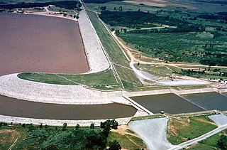
Great Salt Plains Lake is a reservoir located within the Salt Plains National Wildlife Refuge in Alfalfa County, Oklahoma in the United States named because of the salt flats in the area and for the Salt Fork Arkansas River, which is dammed to form the lake. It is notable for the variety of birds that are attracted to Ralstin Island and also for the selenite crystals that can be collected along the shoreline. Recent droughts, most notably that of 2011, have had an adverse effect on the future of the lake.

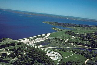
Lake Eufaula, sometimes referred to as Eufaula Lake, is a reservoir in Oklahoma. It is located on the Canadian River, 27 mi (43 km) upstream from its confluence with the Arkansas River and near the town of Eufaula. The lake covers parts of McIntosh County, Pittsburg, Haskell and Okmulgee counties and drains 47,522 square miles (123,080 km2). Water sources include the Canadian, North Fork Canadian and Deep Fork rivers. It is the largest-capacity lake in the state of Oklahoma with a volume of 2,099,000 acre-feet (2.589×10⁹ m3), a surface area of 102,000 acres (410 km2) and 600 miles (970 km) of shoreline.

Curecanti National Recreation Area is a National Park Service unit located on the Gunnison River in western Colorado. Established in 1965, Curecanti National Recreation Area is responsible for developing and managing recreational facilities on three reservoirs, Blue Mesa Reservoir, Morrow Point Reservoir and Crystal Reservoir, constructed on the upper Gunnison River in the 1960s by the U.S. Bureau of Reclamation to better utilize the vital waters of the Colorado River and its major tributaries. A popular destination for boating and fishing, Curecanti offers visitors two marinas, traditional and group campgrounds, hiking trails, boat launches, and boat-in campsites. The state's premiere lake trout and Kokanee salmon fisheries, Curecanti is a popular destination for boating and fishing, and is also a popular area for ice-fishing in the winter months.
Lewisville Lake, formerly known as Garza-Little Elm Reservoir, is a reservoir in North Texas (USA) on the Elm Fork of the Trinity River in Denton County near Lewisville. Originally engineered in 1927 as Lake Dallas, the reservoir was expanded in the 1940s and 1950s and renamed Lewisville Lake. It was built for flood control purposes and to serve as a water source for Dallas and its suburbs, but residents also use it for recreational purposes.

Edgar Evins State Park is a state park in DeKalb County, Tennessee, in the southeastern United States. The park consists of 6,300 acres (25 km2) along the shores of Center Hill Lake, an impoundment of the Caney Fork. The State of Tennessee leases the land from the U.S. Army Corps of Engineers.
Lake Whitney is a flood control reservoir on the main stem of the Brazos River in Texas. It is located on River Mile Marker 442 and controls drainage for 17,656 square miles (45,730 km2) of Texas and parts of New Mexico. The reservoir encompasses a surface area of more than 23,500 acres and 225 miles (362 km) of shoreline. The area consists of rolling, tallgrass prairies; cedar trees; hardwood timber; and 100 ft (30 m) bluffs and rock points. Lake Whitney is also part of the Texas Lakes Trail Region of North Texas.
Lake Georgetown is a reservoir on the north fork of the San Gabriel River in central Texas in the United States. Lake Georgetown is a U.S. Army Corps of Engineers reservoir formed on the San Gabriel by the North San Gabriel Dam, which is located about three miles west of Georgetown, Texas. The dam, lake and all adjacent property are managed by the Fort Worth District of the Corps of Engineers. The dam was officially completed on October 5, 1979, and serves to provide flood control for the community of Georgetown. Lake Georgetown, a popular recreational destination, is also a source of drinking water for Georgetown and the nearby city of Round Rock.

Lake Dardanelle is a major reservoir on the Arkansas River in Arkansas, USA. and is an integral part of the McClellan-Kerr Arkansas River Navigation System (MKARNS), which allows barge transportation from the Mississippi River to the Tulsa Port of Catoosa in northeastern Oklahoma. MKARNS went into service along its full length in 1971.

Blue Mesa Reservoir is an artificial reservoir located on the upper reaches of the Gunnison River in Gunnison County, Colorado. The largest lake located entirely within the state, Blue Mesa Reservoir was created by the construction of Blue Mesa Dam, a 390 feet (120 m) tall earthen fill dam constructed on the Gunnison by the U.S. Bureau of Reclamation in 1966 for the generation of hydroelectric power. Managed as part of the Curecanti National Recreation Area, a unit of the National Park Service, Blue Mesa Reservoir is the largest lake trout and Kokanee salmon fishery in Colorado.

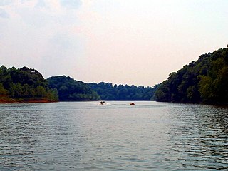
Broken Bow Lake is a reservoir in southeastern Oklahoma, located on Mountain Fork River and 9 miles (14 km) northeast of the town of Broken Bow in McCurtain County. It is one of the largest fresh water lakes within the state of Oklahoma, and a popular tourist destination for locals and visitors from neighboring Texas and Arkansas.
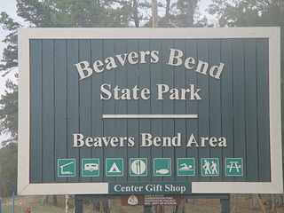
Beavers Bend State Park is a 3,482 acres (14.09 km2) Oklahoma state park located in McCurtain County. It is approximately 10.5 miles (16.9 km) north of Broken Bow on SH-259A. It was established in 1937 and contains Broken Bow Lake.
Hochatown State Park was once an independent Oklahoma state park in far-southeastern Oklahoma, north of the city of Broken Bow. It was combined into Beavers Bend State Park in 2017. It is a popular destination for tourists from Oklahoma and Texas interested in camping or boating on Broken Bow Lake.

The Deep Fork River is an Oklahoma tributary of the North Canadian River. The headwaters flow from northern Oklahoma City and the river empties into the North Canadian River, now impounded by Lake Eufaula.
The Rough River Lake is a Y-shaped reservoir located in Breckinridge, Hardin, and Grayson counties in Kentucky, United States, about 70 miles southwest of Louisville. This lake was created by the building of a dam, begun in 1955 and completed in 1961, 89.3 miles (143.7 km) above the connection between the Rough River and the Green River. The land and water, along with the wildlife, fisheries, and recreational activities, are all managed under the cooperation of the U.S. Army Corps of Engineers and the Commonwealth of Kentucky. A primary attraction is Rough River Dam State Resort Park.
East Fork State Park is 4,870-acre (1,970 ha) public recreation area located around the East Fork of the Little Miami River in Clermont County, twenty miles (32 km) southeast of central Cincinnati, Ohio, in the United States. It maintains the 33-mile "Steve Newman World-Walker" perimeter trail, camping, hiking, swimming, and boating opportunities. The state park has hosted junior and collegiate rowing races, including the US Rowing Youth National Championships. The park's main feature is William H. Harsha Lake, a 2,107-acre (853 ha) reservoir created in 1978. The lake's large earthen dam and smaller saddle dams are operated by the U.S. Army Corps of Engineers.

Hugo Lake is manmade lake located 7 miles (11 km) east of Hugo, in Choctaw County, Oklahoma, United States. It is formed by Hugo Lake Dam on the Kiamichi River 18 miles (29 km) upstream from the Red River. The dam is visible from U.S. Route 70, which crosses its spillway just west of Sawyer. Lake Hugo features approximately 110 miles (180 km) of shoreline and covers over 13,250 acres (53.6 km2), or 20 square miles (52 km2). Its normal pool elevation is 404.5 feet (123.3 m) above sea level and its normal storage capacity is 157,600 acre-feet (194,400,000 m3). At flood stage its elevation is at 437.5 feet (133.4 m) above sea level and it is capable of storing 966,700 acre-feet (1.1924×10⁹ m3) of flood waters. The lake's primary functions are to provide flood control, water storage, and recreational opportunities.
Lake Bardwell is a lake in Ellis County, Texas. The lake was constructed by the United States Army Corps of Engineers in 1965. Lake Bardwell is not used for military operations, and is accessible to the public for recreational purposes; it has seven facilities, but the state public ramp is closed.
Great Blue Heron Provincial Park is a recreational park in the central region of the Canadian province of Saskatchewan in the boreal forest ecozone of Canada. It is adjacent to the eastern boundary of Prince Albert National Park, about 50 kilometres (31 mi) north of the city of Prince Albert. The provincial park was established in 2013 from two pre-existing provincial recreation sites – Emma Lake and Anglin Lake Recreation Sites – and the addition of a large tract of Crown land.


