
The Deep Fork River (Deep Fork of the North Canadian) is an Oklahoma tributary of the North Canadian River. The headwaters flow from northern Oklahoma City and the river empties into the North Canadian River, now impounded by Lake Eufaula.
The Deep Fork River (Deep Fork of the North Canadian) is an Oklahoma tributary of the North Canadian River. The headwaters flow from northern Oklahoma City and the river empties into the North Canadian River, now impounded by Lake Eufaula.
The Deep Fork begins in and around northern Oklahoma City and flows eastward through Oklahoma County where five miles of the river is impounded by Arcadia Lake. Below the lake the river crosses into Lincoln County, winds back and forth across the Creek–Okfuskee county lines, crosses into Okmulgee County, meanders through the 9,600-acre (39 km2) Deep Fork National Wildlife Refuge near the city of Okmulgee, [1] and empties into Eufaula Lake near the Okmulgee–McIntosh County line. Communities along the waterway include Arcadia, Luther, Wellston, Warwick, Sparks, and Welty.
The Deep Fork has a total length of 370 kilometres (230 mi) and has a long narrow drainage basin averaging 40 kilometres (25 mi) in width. [2] The Deep Fork flows through a region of red sandstone hills and red soils and the river is of the same color. The river is channelized in its upper course. The Deep Fork runs in a narrow channel, about 100 ft (30 m) wide at normal flow, frequently obstructed by fallen trees, and often enclosed by steep red clay banks as high as 100 ft (30 m). The river is prone to flooding, especially in its lower course where it is bordered by an extensive area of wetlands, temporary and oxbow lakes, and a deciduous bottom land forest, some of which is included in the Deep Fork NWR. The upper courses of the river are usually bordered by a narrow band of forest. [3]
The Deep Fork is popular for fishing, especially for large flathead catfish. Water quality is considered fair in most of the river. [4] Kayaking and canoeing are also popular. The National Wildlife Refuge has walking trails and blinds for wildlife observation and features a large number of waterfowl and other birds, both migratory and permanent.

Spring Creek is a Deep Fork tributary that begins south of downtown Edmond, Oklahoma, just south of Edmond Memorial High School, and runs easterly. It flows into Arcadia Lake at Spring Creek Park. The western portion of the creek's watershed is heavily populated and the name is applied to many retail and residential developments in south Edmond. A Spring Creek Trail was approved for construction to run along the creek about 3 miles from Interstate 35 east to Spring Creek Park., [5] and was completed. [6]
The Deep Fork has a mean annual discharge of 1,338 cubic feet per second (37.9 cubic metres per second) [7]
During its Indian Territory days, the Deep Fork divided the Iowa and Kickapoo reserves of present-day Lincoln County. Also, the Deep Fork District of the Creek (Muscogee) Nation lay on the east side of the Creek reserve between the Deep Fork and the Canadian River. The area of the old district is mostly within today's Okfuskee County.
In the 1880s, the Deep Fork bottom west of Christian Wells' trading post (present-day Wellston) became a center of Boomer activity. Soldiers from Fort Reno constantly patrolled the area after Wells hired several of David Payne's lieutenants to work at his store. The troopers rounded up Boomers on a number of occasions and returned them to Kansas.
The river is the subject of the song "Deep Fork River Blues," [8] written and performed by folk singer and songwriter Tom Paxton. Paxton lived in Bristow, Oklahoma, during his youth.

Okmulgee County is a county in the U.S. state of Oklahoma. As of the 2020 census, the population was 36,706. The county seat is Okmulgee. Located within the Muscogee Nation Reservation, the county was created at statehood in 1907. The name Okmulgee is derived from the Hitchita word okimulgi, meaning "boiling waters".

McIntosh County is a county located in the U.S. state of Oklahoma. As of the 2020 census, the population was 18,941. Its county seat is Eufaula. The county is named for an influential Muscogee Creek family, whose members led the migration of the Lower Towns to Indian Territory and served as leaders for generations.
Creek County is a county located in the U.S. state of Oklahoma. As of the 2020 census, the population was 71,754. Its county seat is Sapulpa.

Morris is a city in Okmulgee County, Oklahoma, United States. The population was 1,299 at the 2020 census.

Okmulgee is a city in and the county seat of Okmulgee County, Oklahoma, United States, and is part of the Tulsa Metropolitan Area. The name is from the Muskogee word okimulgi, which means "boiling waters". The site was chosen because of the nearby rivers and springs. Okmulgee is 38 miles south of Tulsa and 13 miles north of Henryetta via US-75.

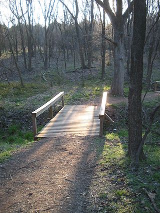
The Deep Fork National Wildlife Refuge (DFNWR) is part of the United States system of National Wildlife Refuges, and is a critical resource for wildfowl that migrate along the Central Flyway in Spring and Fall. It is located in Eastern Oklahoma, near the city of Okmulgee. The preserve runs along both banks of the Deep Fork River for about 20 miles (32 km). According to TravelOK, DFNWR receives about 45,000 visitors every year.

Lake Eufaula, sometimes referred to as Eufaula Lake, is a reservoir in Oklahoma. It is located on the Canadian River, 27 mi (43 km) upstream from its confluence with the Arkansas River and near the town of Eufaula. The lake covers parts of McIntosh County, Pittsburg, Haskell and Okmulgee counties and drains 47,522 square miles (123,080 km2). Water sources include the Canadian, North Fork Canadian and Deep Fork rivers. It is the largest-capacity lake in the state of Oklahoma with a volume of 2,099,000 acre-feet (2.589×10⁹ m3), a surface area of 102,000 acres (410 km2) and 600 miles (970 km) of shoreline.

The Cimarron River extends 698 miles (1,123 km) across New Mexico, Oklahoma, Colorado, and Kansas. The headwaters flow from Johnson Mesa west of Folsom in northeastern New Mexico. Much of the river's length lies in Oklahoma, where it either borders or passes through eleven counties. There are no major cities along its route. The river enters the Oklahoma Panhandle near Kenton, Oklahoma, crosses the corner of southeastern Colorado into Kansas, reenters the Oklahoma Panhandle, reenters Kansas, and finally returns to Oklahoma where it joins the Arkansas River at Keystone Reservoir west of Tulsa, Oklahoma, its only impoundment. The Cimarron drains a basin that encompasses about 18,927 square miles (49,020 km2).

Green Country, sometimes referred to as Northeast Oklahoma, is the northeastern portion of the U.S. state of Oklahoma, which lies west of the northern half of Arkansas, the southwestern corner the way of Missouri, and south of Kansas.

The North Canadian River is a river, 440 miles (710 km) long, in Oklahoma in the United States. It is a tributary of the Canadian River, draining an area of 17,955 square miles (46,500 km2) in a watershed that includes parts of northeastern New Mexico and the Texas Panhandle.
Arcadia Lake is a reservoir in Central Oklahoma County, Oklahoma, United States. The lake is located northeast of Oklahoma City in eastern Edmond, just east of Interstate 35.

State Highway 56 is a state highway in the U.S. state of Oklahoma. The road serves Seminole County, Okfuskee County, and Okmulgee Counties in central and east-central Oklahoma. In Seminole County, it is also designated as the Seminole Nation Highway in honor of the contributions the Seminole Nation has made to the state of Oklahoma.

The Little River is a tributary of the Red River, with a total length of 217 miles (349 km), 130 miles (210 km) within the Choctaw Indian Reservation in southeastern Oklahoma and 87 miles (140 km) in southwestern Arkansas in the United States. Via the Red, it is part of the watershed of the Mississippi River. Six large reservoirs impound the Little River and its tributaries. The drainage basin of the river totals 4,204 square miles (10,890 km2), 2,204 square miles (5,710 km2) in Oklahoma and 2,036 square miles (5,270 km2) in Arkansas. The Little River and its upper tributaries are popular for recreational canoeing and kayaking.

Great Salt Plains State Park is a 840-acre (3.4 km2) Oklahoma state park located in Alfalfa County, Oklahoma. It is located 8 miles (13 km) north of Jet, Oklahoma on SH-38 and 12 miles (19 km) east of Cherokee. Recreational opportunities at Great Salt Plains State Park include boating, camping, picnicking, swimming, hiking, mountain biking and exploring. The Great Salt Plains Lake is located at the park and covers 9,300 acres (38 km2) with 41 miles (66 km) of shoreline and is a shallow, salty lake with fishing opportunities for catfish, saugeye, sandbass and hybrid striper. The average depth is reportedly 4 feet (1.2 m) and the impoundment capacity is 31,420 acre-feet. Salinity of the water in the reservoir is one-fourth that of sea water. Personal watercraft are not recommended. The park has RV and tent sites, comfort stations with showers, cabins, picnic sites, group shelters, swimming beach, playgrounds, boat ramps, fishing dock and equestrian trails. Horse rental is not available.
Muddy Boggy Creek, also known as the Muddy Boggy River, is a 175-mile-long (282 km) river in south central Oklahoma. The stream headwaters arise just east of Ada in Pontotoc County. It is a major tributary of the Red River in south central Oklahoma. Clear Boggy Creek is a major tributary which enters the Muddy Boggy at a location known as River Mile 24 in Choctaw County. The river is inhabited by over one hundred species of fish.
The Okmulgee Northern Railway Company (ON), originally the Coalton Railway, was a shortline rail carrier in Okmulgee County, Oklahoma. It was in operation from 1916 to 1964.
35°21′34″N95°36′39″W / 35.35944°N 95.61083°W
| Authority control databases: National |
|---|