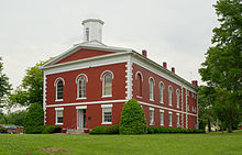
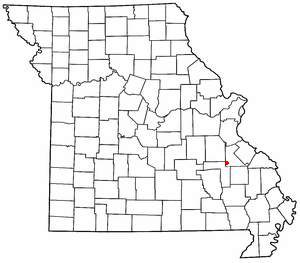
Iron County is a county located in the Lead Belt region in the U.S. state of Missouri. As of the 2020 census, the population was 9,537. The largest city and county seat is Ironton. Iron County was officially organized on February 17, 1857, and was named after the abundance of iron ore found within its borders.

Fredericktown is a city in and the county seat of Madison County, Missouri, United States, in the northeastern foothills of the St. Francois Mountains. The population was 4,429 at the 2020 census. The city is surrounded on three sides by the easternmost parcel of the Mark Twain National Forest.

Farmington is a city in St. Francois County located about 75 miles (121 km) southwest of St. Louis in the Lead Belt region in Missouri. As of the 2020 census, the population was 18,217. It is the county seat of St. Francois County. Farmington was established in 1822 as Murphy's Settlement, named for William Murphy of Kentucky, who first visited the site in 1798. When St. Francois County was organized, the town was briefly called St. Francois Court House and later renamed to Farmington.

The St. Francois Mountains in southeast Missouri are a mountain range of Precambrian igneous mountains rising over the Ozark Plateau. This range is one of the oldest exposures of igneous rock in North America. The name of the range is spelled out as Saint Francois Mountains in official GNIS sources, but it is sometimes misspelled in use as St. Francis Mountains to match the anglicized pronunciation of both the range and St. Francois County.
The Battle of Fort Davidson, also known as the Battle of Pilot Knob, was a battle of Price's Missouri Expedition fought on September 27, 1864, near Pilot Knob, Missouri. Confederate troops under the command of Major-General Sterling Price had entered Missouri in September 1864 with hopes of challenging Union control of the state. On September 24, Price learned that Union troops held Pilot Knob. Two days later, he sent part of his command north to disrupt and then moved towards Pilot Knob with the rest of his army. The Confederate divisions of Major-General James Fagan and Brigadier-General John Marmaduke drove Union troops under Brigadier-General Thomas Ewing and Major James Wilson from the lower Arcadia Valley into Fort Davidson on September 26 and on the morning of September 27.

The American Bottom is the flood plain of the Mississippi River in the Metro-East region of Southern Illinois, extending from Alton, Illinois, south to the Kaskaskia River. It is also sometimes called "American Bottoms". The area is about 175 square miles (450 km2), mostly protected from flooding in the 21st century by a levee and drainage canal system. Immediately across the river from St. Louis, Missouri, are industrial and urban areas, but nearby marshland, swamps, and the Horseshoe Lake are reminders of the Bottoms' riparian nature.

The Southeast Missouri Lead District, commonly called the Lead Belt, is a lead mining district in the southeastern part of Missouri. Counties in the Lead Belt include Saint Francois, Crawford, Dent, Iron, Madison, Reynolds, and Washington. This mining district is the most important and critical lead producer in the United States.
Iron Mountain is an unincorporated community in southwestern St. Francois County, Missouri, United States. It is located approximately six miles south of Bismarck. The community was founded in 1836 as a mining site and it was named for nearby Iron Mountain, once thought to be made completely of iron ore. A post office called Iron Mountain was established in 1846, and remained in operation until 1978.

Southwest Garden is a neighborhood of St. Louis, Missouri, located south of The Hill and Forest Park Southeast, west of the Missouri Botanical Garden and Tower Grove Park, east of Lindenwood Park and Clifton Heights, and north of North Hampton.

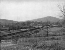
Pilot Knob is located in the Arcadia Valley of Iron County, Missouri, between the towns of Ironton and Pilot Knob. Pilot Knob, so named because of its distinctive shape and prominent position, reaches an elevation of 1,470 feet (450 m) rising 581 feet (177 m) above the Arcadia Valley floor and has a large deposit of iron ore in its upper regions. Pilot Knob is a peak in the St. Francois Mountains.

Fort Davidson, a fortification near the town of Pilot Knob, Missouri, was the site of the Battle of Fort Davidson during the American Civil War. Built by Union Army soldiers during the American Civil War, the fort repulsed Confederate attacks during the Battle of Fort Davidson on September 27, 1864, during Price's Raid. That night, the Union garrison blew up the fort's magazine and abandoned the site. A mass grave was constructed on the site to bury battlefield dead. After the war, the area was used by a mining company, before passing into private hands and eventually the administration of the United States Forest Service. In 1968, the Battle of Pilot Knob State Historic Site was created as a Missouri State Park. The fort itself was added to the National Register of Historic Places in 1970. As of 2020, a visitors center containing a museum is located within the park. The museum contains a fiber optic display, as well as artifacts including Brigadier General Thomas Ewing Jr.'s sword. The fort's walls are still visible, as is the crater created when the magazine was detonated. A monument marks the location of the mass grave.
Fort Hovey was a small Civil War era earth-and-wood fort built on a hill overlooking the junction of the road running south out of Ironton, Missouri and the road running east to Fredericktown, Missouri. Fort Hovey was intended to help protect the Arcadia Valley and the iron mines located on Pilot Knob. The fort was located on Fort Hill near the town of Arcadia, Missouri on the (then) property of the Fort Hill Methodist Episcopal Church, South and the present day Arcadia Valley United Presbyterian Church. This fortification was named Fort Hovey in honor of the commander of the 33rd Illinois Volunteer Infantry Regiment (Union), Colonel Charles E. Hovey. The 33rd. Illinois was stationed there during the Autumn and Winter of 1861-62, at which time they built the fort.
Desloge Consolidated Lead Company was a lead mining company in the Southeast Missouri Lead District that was operated by the Desloge family in the 19th and early 20th century. The Desloge lead operations in the "Old Lead Belt", in the eastern Ozark Mountains, helped Missouri become the world's premier lead mining area.

The Missouri Valley Bridge & Iron Co., also known as Missouri Valley Bridge Company, was a engineering, construction, and steel fabrication firm that operated through the late nineteenth and most of the twentieth centuries. It was based in Leavenworth, Kansas, with a WWII facility in Evansville, Indiana.

The Iron County MRA is a Multiple Resource Area addition to the National Register of Historic Places, which includes 72 separate structures and historic districts within Iron County, Michigan, United States of America. These properties were identified and placed on the Register in 1983, with the exception of one property that was placed on the Register in 1993.
Knob Creek is a stream in Iron and St. Francois counties in the U.S. state of Missouri. It is a tributary of Stouts Creek.
Shepherd Mountain is a summit in Iron County in the U.S. state of Missouri. Shepherd Mountain lies just west of Ironton and Stouts Creek in the Arcadia Valley.
Oak Mountain is a summit in the southwestern corner of St. Francois County in the U.S. state of Missouri. The summit has an elevation of 1,631 feet (497 m). The peak is on a north-south trending ridge that extends south into Iron County and the city of Pilot Knob lies just southwest of the mountain. The community of Middlebrook is to the northwest and Iron Mountain Lake is to the north. The source area of Knob Creek is on the west flank of the mountain.

Syenite is an unincorporated community in southern St. Francois County, in the U.S. state of Missouri. The community lies on Missouri Route DD, west of U.S. Route 67. Knob Lick lies approximately 1.5 miles to the east and the St. Francis River valley is to the north and west. Knob Lick Mountain lies about one mile to the south-southeast.