Piraeus is a port city within the Athens urban area, in the Attica region of Greece. It is located eight kilometres (5 mi) southwest of Athens' city centre along the east coast of the Saronic Gulf in the Athens Riviera.

Camulodunum, the Ancient Roman name for what is now Colchester in Essex, was an important castrum and city in Roman Britain, and the first capital of the province. A temporary "strapline" in the 1960s identifying it as the "oldest recorded town in Britain" has become popular with residents and is still used on heritage roadsigns on trunk road approaches. Originally the site of the Brythonic-Celtic oppidum of Camulodunon, capital of the Trinovantes and later the Catuvellauni tribes, it was first mentioned by name on coinage minted by the chieftain Tasciovanus some time between 20 and 10 BC. The Roman town began life as a Roman legionary base constructed in the AD 40s on the site of the Brythonic-Celtic fortress following its conquest by the Emperor Claudius. After the early town was destroyed during the Iceni rebellion in AD 60/61, it was rebuilt, reaching its zenith in the 2nd and 3rd centuries. During this time it was known by its official name Colonia Claudia Victricensis, often shortened to Colonia Victricensis, and as Camulodunum, a Latinised version of its original Brythonic name. The town was home to a large classical temple, two theatres, several Romano-British temples, Britain's only known chariot circus, Britain's first town walls, several large cemeteries and over 50 known mosaics and tessellated pavements. It may have reached a population of 30,000 at its height.

Olynthus is an ancient city in present-day Chalcidice, Greece. It was built mostly on two flat-topped hills 30–40m in height, in a fertile plain at the head of the Gulf of Torone, near the neck of the peninsula of Pallene, about 2.5 kilometers from the sea, and about 60 stadia from Poteidaea.
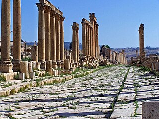
A cardo was a north–south street in Ancient Roman cities and military camps as an integral component of city planning. The cardo maximus, or most often the cardo, was the main or central north–south-oriented street.

Paestum was a major ancient Greek city on the coast of the Tyrrhenian Sea, in Magna Graecia. The ruins of Paestum are famous for their three ancient Greek temples in the Doric order dating from about 550 to 450 BC that are in an excellent state of preservation. The city walls and amphitheatre are largely intact, and the bottom of the walls of many other structures remain, as well as paved roads. The site is open to the public, and there is a modern national museum within it, which also contains the finds from the associated Greek site of Foce del Sele.
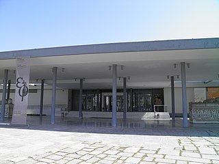
The Archaeological Museum of Thessaloniki is a museum in Thessaloniki, Central Macedonia, Greece. It holds and interprets artifacts from the Prehistoric, Archaic, Classical, Hellenistic and Roman periods, mostly from the city of Thessaloniki but also from the region of Macedonia in general.
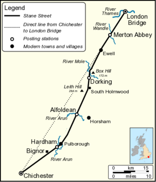
Stane Street is the modern name of the 91 km-long (57 mi) Roman road in southern England that linked Londinium (London) to Noviomagus Reginorum (Chichester). The exact date of construction is uncertain; however, on the basis of archaeological artefacts discovered along the route, it was in use by 70 AD and may have been built in the first decade of the Roman occupation of Britain.

In ancient Rome, the domus was the type of town house occupied by the upper classes and some wealthy freedmen during the Republican and Imperial eras. It was found in almost all the major cities throughout the Roman territories. The modern English word domestic comes from Latin domesticus, which is derived from the word domus. Along with a domus in the city, many of the richest families of ancient Rome also owned a separate country house known as a villa. Many chose to live primarily, or even exclusively, in their villas; these homes were generally much grander in scale and on larger acres of land due to more space outside the walled and fortified city.

Trajan's Forum was the last of the Imperial fora to be constructed in ancient Rome. The architect Apollodorus of Damascus oversaw its construction.
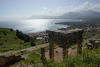
Soluntum or Solus was an ancient city on the Tyrrhenian coast of Sicily near present-day in the comune of Santa Flavia, Italy. The site is a major tourist attraction. The city was founded by the Phoenicians in the sixth century BC and was one of the three chief Phoenician settlements in Sicily in the archaic and classical periods. It was destroyed at the beginning of the fourth century BC and re-founded on its present site atop Monte Catalfano. At the end of the fourth century BC, Greek soldiers were settled there and in the 3rd century BC the city came under the control of the Roman Republic. Excavations took place in the 19th century and in the mid-20th century. Around half of the urban area has been uncovered and it is relatively well preserved. The remains provide a good example of an ancient city in which Greek, Roman and Punic traditions mixed.

The Archaeological Museum of Dion is a museum in Dion in the Pieria regional unit of Central Macedonia, Greece.

The Sanctuary of Aphrodite Urania was located north-west of the Ancient Agora of Athens and dedicated to the goddess Aphrodite under her epithet Urania. It has been identified with a sanctuary found in this area in the 1980s. This sanctuary initially consisted of a marble altar that was built around 500 BC and was gradually buried as the ground level rose. Another structure, perhaps a fountainhouse, was built to the west ca. 100 BC. In the early 1st century AD, an Ionic tetrastyle prostyle temple closely modelled on the Erechtheion's north porch, that was built to the north of the altar.

Rhodiapolis, also known as Rhodia (Ῥοδία) and Rhodiopolis (Ῥοδιόπολις), was a city in ancient Lycia. Today it is located on a hill northwest of the modern town Kumluca in Antalya Province, Turkey.

The Citânia de Briteiros is an archaeological site of the Castro culture located in the Portuguese civil parish of Briteiros São Salvador e Briteiros Santa Leocádia in the municipality of Guimarães; important for its size, "urban" form and developed architecture, it is one of the more excavated sites in northwestern Iberian Peninsula. Although primarily known as the remains of an Iron Age proto-urban hill fort, the excavations at the site have revealed evidence of sequential settlement, extending from the Bronze to Middle Ages.

Roman Cyprus was a small senatorial province within the Roman Empire. While it was a small province, it possessed several well known religious sanctuaries and figured prominently in Eastern Mediterranean trade, particularly the production and trade of Cypriot copper. The island of Cyprus was situated at a strategically important position along Eastern Mediterranean trade routes, and had been controlled by various imperial powers throughout the first millennium BC. including: the Assyrians, Egyptians, Persians, Macedonians, and eventually the Romans. Cyprus was annexed by the Romans in 58 BC, but turbulence and civil war in Roman politics did not establish firm rule in Cyprus until 31 BC when Roman political struggles ended by Battle of Actium, and after about a decade, Cyprus was assigned a status of senatorial province in 22 BC. From then until the 7th century AD, Cyprus was controlled by the Romans. Cyprus officially became part of the Eastern Roman Empire in 293 AD.

The Archaeological Museum of Pella is a museum in Pella in the Pella regional unit of Central Macedonia. The building was designed by architect Kostas Skroumpellos and is on the site of the ancient city of Pella. It was completed in 2009 with the support of the Greece's Third Community Support Framework.

Celsa was an important pre-Roman and Roman city located near the modern town of Velilla de Ebro, Aragon, Spain.

The Archaeological Park of Dion is the most important archaeological site at Mount Olympus in Greece, located in Dion. In the area comprised by the Archaeological Park of Dion, sanctuaries were found from the Hellenistic and Roman periods. The park displays the importance of ancient Dion in the history of Pieria.
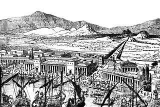
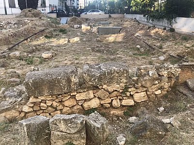
The Makra Stoa is an archaeological site which formed part of the urban fabric of the ancient city of Piraeus in Athens, Greece

Rondini Square is an archaeological site which forms part of the ancient city of Piraeus, in Athens, Greece.


