
El-Sayed Glacier is a glacier about 15 nautical miles long which drains the northeast slopes of Zuncich Hill in Marie Byrd Land. It flows northeast to enter Land Glacier at the south side of Mount Shirley. It was mapped by the United States Geological Survey from surveys and U.S. Navy air photos, 1959–65, and was named by the Advisory Committee on Antarctic Names for Sayed Z. El-Sayed, a United States Antarctic Research Program oceanographer on the International Weddell Sea Oceanographic Expeditions, 1967–68 and 1969–70.
Astrolabe Island, located at 63°17′S58°40′W, is an island 5 km (3 mi) long, lying in the Bransfield Strait 23 km (14 mi) northwest of Cape Ducorps, Trinity Peninsula in Antarctica. It was discovered by the French expedition, 1837–40, under Captain Jules Dumont d'Urville, and named by him for his chief expedition ship, the Astrolabe. The island was photographed from the air and triangulated by FIDASE, 1956-57.
Schweitzer Glacier is a glacier which drains west along the north side of Littlewood Nunataks into Vahsel Bay. The Lerchenfeld Glacier, trending west-northwestward, coalesces with the lower portion of this glacier. Discovered by the German Antarctic Expedition, 1911–12, under Wilhelm Filchner. He named it for Major Schweitzer, first president of the German Antarctic Expedition Society.
O'Hara Glacier is a glacier just west of Ackroyd Point, flowing northwest into the south side of Yule Bay, Victoria Land. Mapped by United States Geological Survey (USGS) from surveys and United States Navy air photos, 1960-63. Named by Advisory Committee on Antarctic Names (US-ACAN) for Norbert W. O'Hara, a member of the United States Antarctic Research Program (USARP) party which conducted studies of the Ross Ice Shelf, 1965-66.

Andrew Glacier is a glacier 3 nautical miles (6 km) long, flowing northeast into Ognen Cove in Charcot Bay immediately west of the Webster Peaks on Trinity Peninsula, northern Graham Land. It was charted in 1948 by the Falkland Islands Dependencies Survey (FIDS) who named the feature for Dr. James Darby Andrew, medical officer at the FIDS Hope Bay station in 1946–47.

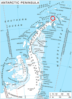
The Beaver Rocks are a group of rocks lying 2 nautical miles (4 km) off Belitsa Peninsula at a point midway between Notter Point and Cape Kjellman, Trinity Peninsula. They were named by the UK Antarctic Place-Names Committee after the de Havilland Beaver, a type of aircraft used by the British Antarctic Survey.
Bowsprit Point is the northeast point of Leskov Island, South Sandwich Islands. The name applied by the UK Antarctic Place-Names Committee in 1971 suggests the resemblance of this feature to a bowsprit, or prow of a ship.
Childs Glacier is a glacier in the Neptune Range of the Pensacola Mountains, draining westward from Roderick Valley to enter Foundation Ice Stream. It was mapped by the United States Geological Survey from surveys and from U.S. Navy air photos, 1956–66, and named by the Advisory Committee on Antarctic Names for John H. Childs, a builder at Ellsworth Station, winter 1958.
Strange Glacier is a glacier in the Latady Mountains, draining southeast along the south side of Crain Ridge to enter Gardner Inlet between Schmitt Mesa and Mount Austin, in Palmer Land. Mapped by United States Geological Survey (USGS) from surveys and U.S. Navy air photos, 1961-67. Named by Advisory Committee on Antarctic Names (US-ACAN) for Donald L. Strange, hospital corpsman at South Pole Station in 1964.
Cape Green is a low ice cliff forming the southeastern extremity of Tabarin Peninsula, on the northeast end of the Antarctic Peninsula. It was charted by the Falkland Islands Dependencies Survey (FIDS) in 1946 and named for Michael C. Green, a FIDS geologist who lost his life when the base hut at Hope Bay burned in November 1948. Neighbouring Cape Burd commemorates Oliver Burd, a FIDS meteorologist who lost his life in the same fire.
Puzzle Islands is a group of small islands, rocks and reefs at the mouth of Flandres Bay, lying 1 nautical mile (1.9 km) west of Menier Island off the west coast of Graham Land. First charted by the French Antarctic Expedition under Charcot, 1903-05. So named by the United Kingdom Antarctic Place-Names Committee (UK-APC) in 1958; the group is often hidden by icebergs which come to rest in the surrounding shallow waters.
The Eden Rocks are two rocks lying 1.5 km off the east coast of Dundee Island, at the northern end of the Antarctic Peninsula. A small island was reported there on 30 December 1842 by Captain James Clark Ross of the Royal Navy, who named it "Eden Island" for Captain Charles Eden. Following a survey by the Falkland Islands Dependencies Survey in 1953, it was reported that the feature consists of two rocky islets rising to about 90 m in height and lying close together.
Hansen Inlet is an ice-filled inlet between Cape Schlossbach and Cape Cox, along the east coast and near the base of the Antarctic Peninsula. It was mapped by the United States Geological Survey from ground surveys and U.S. Navy air photos, 1961–67, and was named by the Advisory Committee on Antarctic Names for B. Lyle Hansen who, with Herbert T. Ueda, was in charge of the deep-core drilling program at Byrd Station for several seasons, 1966–69.
Marr Ice Piedmont is a large ice piedmont which covers the northwestern half of Anvers Island, in the Palmer Archipelago, Antarctica. This feature was presumably first seen by a German expedition under Eduard Dallmann, 1873–74, and was first roughly surveyed by the French Antarctic Expedition, 1903–05, and French Antarctic Expedition, 1908–10, both under Jean-Baptiste Charcot. It was named by the UK Antarctic Place-Names Committee for British marine biologist James W.S. Marr, first commander of the Falkland Islands Dependencies Survey, 1943–45, and leader of the base at nearby Port Lockroy. Marr was also a member of the British Australian New Zealand Antarctic Research Expedition under Mawson, 1929–31, and of Shackleton's expedition of 1921–22.
MacNamara Glacier is a glacier in the Patuxent Range of the Pensacola Mountains in Antarctica, draining northeastward between the Thomas Hills and Anderson Hills to Foundation Ice Stream. It was mapped by the United States Geological Survey from surveys and U.S. Navy air photos, 1956–66, and was named by the Advisory Committee on Antarctic Names for Edlen E. MacNamara, a United States Antarctic Research Program exchange scientist at Molodezhnaya Station, winter 1967.
Thanaron Point is a rock point on the east side of the end of Malorad Glacier, situated 8 nautical miles (15 km) east-northeast of Cape Roquemaurel on Trinity Peninsula, Antarctica. Named in 1838 by the French expedition under Captain Jules Dumont d'Urville after Lieutenant Charles Thanaron of the expedition ship Zelee.
Taylor Point is a point forming the north limit of Destruction Bay, on the east coast of King George Island in the South Shetland Islands. Named by the United Kingdom Antarctic Place-Names Committee (UK-APC) in 1960 for D. Taylor, Master of the Hobart sealing vessel Caroline, which visited the South Shetland Islands in 1821-22.
Russell West Glacier is a glacier, 11 nautical miles (20 km) long and 4 nautical miles (7 km) wide, which lies immediately north of Detroit Plateau and flows from Mount Canicula, Verdikal Gap and Trajan Gate westward into Bone Bay on the north side of Trinity Peninsula. This glacier together with Russell East Glacier, which flows eastward into Prince Gustav Channel on the south side of Trinity Peninsula, form a through glacier across the north part of Antarctic Peninsula. It was first surveyed in 1946 by the Falkland Islands Dependencies Survey (FIDS). Named by the United Kingdom Antarctic Place-Names Committee (UK-APC) for V.I. Russell, surveyor and leader of the FIDS base at Hope Bay in 1946.
Rudder Point is the high, rocky southeast point of Leskov Island, South Sandwich Islands. The name, applied by United Kingdom Antarctic Place-Names Committee (UK-APC) in 1971, refers to the resemblance of the feature to a large ruder in contradistinction to Bowsprit Point at the other end of the island.

Lever Glacier is a glacier, 1.5 nautical miles (3 km) wide at its mouth and at least 6 nautical miles (11 km) long, flowing west-northwest, then west-southwest into the head of the northern arm of Beascochea Bay north of Chorul Peninsula, on the west coast of Graham Land, Antarctica. The glacier was first sighted and roughly surveyed in 1909 by the French Antarctic Expedition. It was resurveyed in 1935 by the British Graham Land Expedition (BGLE) under John Rymill, and named in 1954 for William Lever, 2nd Viscount Leverhulme, who contributed toward the cost of the BGLE.


