Related Research Articles

The Firth of Clyde is the mouth of the River Clyde. It is located on the west coast of Scotland and constitutes the deepest coastal waters in the British Isles. The firth is sheltered from the Atlantic Ocean by the Kintyre peninsula, which encloses the outer firth in Argyll and Ayrshire. The Kilbrannan Sound is a large arm of the Firth of Clyde, separating the Kintyre Peninsula from the Isle of Arran. Within the Firth of Clyde is another major island – the Isle of Bute. Given its strategic location at the entrance to the middle and upper Clyde, Bute played a vital naval military role during World War II.

Dunoon is the main town on the Cowal peninsula in the south of Argyll and Bute, Scotland. It is located on the western shore of the upper Firth of Clyde, to the south of the Holy Loch and to the north of Innellan. As well as forming part of the council area of Argyll and Bute, Dunoon also has its own community council. Dunoon was a burgh until 1976.

Gourock is a town in the Inverclyde council area and formerly a burgh of the County of Renfrew in the west of Scotland. It was a seaside resort on the East shore of the upper Firth of Clyde. Its main function today is as a residential area, extending contiguously from Greenock, with a railway terminus and ferry services across the Clyde.

Cowal is a rugged peninsula in Argyll and Bute, on the west coast of Scotland. It is bounded on the west by Loch Fyne and on the east by Loch Long and the Firth of Clyde. The Kyles of Bute separate it from Bute to the south.

The Holy Loch is a sea loch, a part of the Cowal peninsula coast of the Firth of Clyde, in Argyll and Bute, Scotland.

Sandbank is a village on the Cowal peninsula in Argyll and Bute, Scotland. It is located 2.5 miles north of Dunoon on the coastal A815 or the inland A885 and sits on the southern shore of the Holy Loch, branching off the Firth of Clyde.

Inchkeith is an island in the Firth of Forth, Scotland, administratively part of the Fife council area.

Cloch or Cloch Point is a point on the coast of the Firth of Clyde, Scotland. There has been a lighthouse since 1797 to warn ships off The Gantocks.
The Tail of the Bank is the name given to the anchorage in the upper Firth of Clyde immediately North of Greenock, between Inverclyde and Argyll and Bute. This area of the Firth gets its name from the deep water immediately to the west of the sandbank which marks the entrance to the navigable channel up the Estuary of the River Clyde.

Lyle Hill stands at the West End of Greenock in Inverclyde, Scotland. It has scenic viewpoints accessible from Lyle Road, which was constructed in 1879–1880 and named after Provost Abram Lyle, well known as a sugar refiner. The hill's highest point is Craigs Top at 426 feet above sea level, and before the road was constructed the hill was known as the Craigs, or as the Bingens.
Elcho Castle is located close to the south bank of the River Tay approximately four miles south-east of Perth, Scotland, in the region of Perth and Kinross. It was maintained by Clan Wemyss from its construction around 1560 until it was put into the care of the Secretary of State for Scotland in the early 20th century, though was not occupied for the entire time. In around 1830 it was re-roofed and a nearby cottage constructed. The castle has been a scheduled monument since 1920 on the grounds of being "a particularly fine example of a Medieval tower-house", and the cottage became a listed building in 1971 in recognition of its national importance. The castle is unusual in that it has both en suite guest accommodation like a mansion, but also a large number of gun loops.

Tarbat is a civil parish in Highland, Scotland, in the north-east corner of Ross and Cromarty.
Innerwick is a coastal civil parish and small village, which lies in the east of East Lothian, five miles from Dunbar and approximately 32 miles from Edinburgh.

Hunters Quay is a village, on the Cowal peninsula in Argyll and Bute, Scottish Highlands. Situated between Kirn to the south and Ardnadam to the north, Hunters Quay is the main base of Western Ferries, operating between Hunters Quay and McInroy's Point.

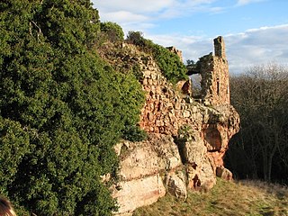
Dunoon Castle is a ruined castle in Dunoon, Argyll and Bute, Scotland. The castle sat upon a cone-shaped hill about 80 feet (24 m) high. Very little remains of the castle's structure today. Castle House, built in 1822, stands a few yards north of the castle ruins.

Historic Environment Scotland (HES) is an executive non-departmental public body responsible for investigating, caring for and promoting Scotland's historic environment. HES was formed in 2015 from the merger of government agency Historic Scotland with the Royal Commission on the Ancient and Historical Monuments of Scotland (RCAHMS). Among other duties, Historic Environment Scotland maintains more than 300 properties of national importance including Edinburgh Castle, Skara Brae and Fort George.
The Gantocks is a small group of rocks lying off Dunoon in the upper Firth of Clyde, West of Scotland.

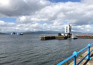
Dunoon Pier is a Victorian pier in Dunoon, Argyll and Bute, Scotland. It is owned by Argyll and Bute Council, and was completed in its current form in 1898. Reaching out into the Firth of Clyde, the earliest parts of the pier date to 1835. It is now a Category A listed structure and, according to Historic Environment Scotland, the best surviving example of a timber ferry pier in Scotland.
Coastal fortifications in Scotland played a vital role during the World Wars, protecting shipping as they mustered to convoy. New fortifications were built and old defences were also rebuilt or strengthened around the Scottish coast in case of invasion. New technologies like Radar were also deployed.
References
- ↑ "The Times", 21 January 1901
- ↑ "Ardhallow Battery and Defences (SM13683)". portal.historicenvironment.scot.
- ↑ "Clyde Defences, Dunoon, Castle Gardens, Dunoon Battery | Canmore". canmore.org.uk.
- ↑ "Secret Scotland - Cloch Boom". secretscotland.org.uk.
- ↑ "Cloch Lighthouse, coast battery 295m SSE of (SM12803)". portal.historicenvironment.scot.
- ↑ "Clyde Defences, Cloch Point To Dunoon Anti-submarine Boom | Canmore". canmore.org.uk.