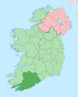
County Cork is the largest and the southernmost county of Ireland, situated in the province of Munster and named after the city of Cork, Ireland's second-largest city. The Cork County Council is the local authority for the county. Its largest market towns are Mallow, Macroom, Midleton, and Skibbereen. As of 2016 the county had a population of 542,868, making it the third-most populous county in Ireland. Notable Corkonians include Michael Collins, Jack Lynch, and Sonia O'Sullivan.
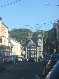
Mallow is a town in County Cork, Ireland, approximately thirty-five kilometres north of Cork. Mallow is in the barony of Fermoy.

Glanmire is a town nine kilometres outside Cork city centre, in the civil parish of Rathcooney, County Cork, Ireland. Glanmire is within the Cork North-Central Dáil constituency and the administrative area of Cork City Council.

Dungarvan is a coastal town and harbour in County Waterford, on the south-east coast of Ireland. Prior to the merger of Waterford County Council with Waterford City Council in 2014, Dungarvan was the county town and administrative centre of County Waterford. Waterford City and County Council retains administrative offices in the town. The town's Irish name means "Garbhann's fort", referring to Saint Garbhann who founded a church there in the seventh century. The town lies on the N25 road, which connects Cork, Waterford and Rosslare Europort.
Kanturk is a town in the north west of County Cork, Ireland. It is situated at the confluence of the Allua (Allow) and Dallow (Dalua) rivers, which stream further on as tributaries to the River Blackwater. It is about 50 kilometres from Cork, Blarney and Limerick, and lies just north of the main N72 road, 15 km from Mallow and about 40 km from Killarney. Kanturk is within the Cork North-West Dáil constituency.

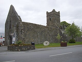
Millstreet is a town in north County Cork, Ireland, with a population of 1,555.

Durrus is a village and civil parish in West Cork in Ireland. It is situated six miles (9.7 km) from Bantry in County Cork, at the head of the Sheep's Head and the Mizen Head peninsulas.

Shandon is a district on the north-side of Cork city. Shandon lies north of the River Lee and North Gate Bridge, the northernmost point of the medieval city. Several landmarks of Cork's north-side are located in the area, including the bell tower of the Church of St Anne, the Cathedral of St Mary and St Anne, Saint Mary’s Dominican Church & Priory, and Firkin Crane Arts Centre.

Whitegate is a small village in East Cork on the eastern shore of Cork Harbour in County Cork, Ireland. It lies within the townlands of Ballincarroonig and Corkbeg. Whitegate is within the Cork East Dáil constituency.

Farran is a village in County Cork, Ireland, in the parish of Ovens. It lies on the southside of the River Lee. Farran is 12 miles (19 km) west from Cork City on the N22 road.
Boherbue or Boherboy is a village in North West County Cork, Ireland. The village is in the civil parish of Kilmeen in the Barony of Duhallow, and spans the townlands of Gneeves, Laharan and Derrynatubbrid. Boherbue is within the Cork North-West Dáil constituency.

Ballyvolane is a townland and suburb of Cork on the north side of the city, that borders Mayfield, White's Cross, Glenheights and Dublin Hill. The townland of Ballyvolane is in the civil parish of St. Anne's Shandon. Ballyvolane is within the Cork North-Central Dáil constituency.
Fermoy is a barony in County Cork in Ireland. It is bordered by the baronies of Orrery and Kilmore to the north-west; Duhallow to the west; Barretts to the south-west; Barrymore to the south; Condons and Clangibbon to the east; and Coshlea, County Limerick to the north. It is bounded to the south by the Nagle Mountains and the valley of the Munster Blackwater. The Ballyhoura Mountains mark the northern boundary. A tributary of the Blackwater, the Awbeg has two branches in its upper stretches; one branch forms the northern boundary while the other near Buttevant, forms the western limit. To the east, lies another Blackwater tributary, the Funcheon. Anomalously, the namesake town of Fermoy is actually in the barony of Condons and Clangibbon. The town with the greatest population in the barony is Mallow.

Ratass Church is a medieval church with ogham stone forming a National Monument in Tralee, Ireland.

Tonaknock Cross is a high cross and National Monument located in County Kerry, Ireland.
Leacanabuaile is a stone ringfort (cashel) and National Monument in County Kerry, Ireland. Leacanabuaile is immediately northwest of Cahergal, 3 km (1.9 mi) northwest of Cahirciveen.

Killursa is a medieval church and National Monument in County Galway, Ireland.

Illaunloughan is a medieval Christian monastery and National Monument located in County Kerry, Ireland. The site is located on a tiny island of 0.3 acres in Portmagee Channel, a channel separating Valentia Island from the Iveragh Peninsula.

Church Island is a medieval Christian monastery and National Monument located in Lough Currane, Ireland.
Dunmore Abbey is a medieval Augustinian friary and National Monument located in County Galway, Ireland.
