This article needs additional citations for verification .(February 2024) |
Area codes 0-99 serve the three largest cities in Mexico. The country code of Mexico is +52. [1]
Area code 33 serves the Metropolitan area of Guadalajara, Jalisco, area code 55 and area code 56 serve the Metropolitan area of Mexico City (Mexico State and the CDMX) and area code 81 serves the Metropolitan area of Monterrey, Nuevo León.
(For other areas, see Area codes in Mexico by code).
City | State | Code |
Base Aérea Militar No. 5 | Jalisco | 33 |
Buenavista | Jalisco | 33 |
Cajititlán | Jalisco | 33 |
Centro de Readaptación Social | Jalisco | 33 |
Club de Golf Santa Anita | Jalisco | 33 |
Colonia Guadalupana | Jalisco | 33 |
Coyula | Jalisco | 33 |
El Salto | Jalisco | 33 |
Emiliano Zapata | Jalisco | 33 |
Guadalajara | Jalisco | 33 |
La Calera | Jalisco | 33 |
La Primavera | Jalisco | 33 |
La Tijera | Jalisco | 33 |
La Venta del Astillero | Jalisco | 33 |
Las Cañadas (Bosques de San Isidro) | Jalisco | 33 |
Las Pintas | Jalisco | 33 |
Loma Bonita | Jalisco | 33 |
Nicolás R. Casillas | Jalisco | 33 |
Nuevo México | Jalisco | 33 |
Palomar | Jalisco | 33 |
Puente Grande | Jalisco | 33 |
Rancho Contento | Jalisco | 33 |
Río Blanco | Jalisco | 33 |
San Esteban | Jalisco | 33 |
San Gaspar de las Flores | Jalisco | 33 |
San Isidro Mazatepec | Jalisco | 33 |
San José del Castillo | Jalisco | 33 |
San Juan Evangelista | Jalisco | 33 |
San Martín de las Flores de Abajo | Jalisco | 33 |
San Miguel Cuyutlán | Jalisco | 33 |
San Nicolás | Jalisco | 33 |
San Sebastián El Grande | Jalisco | 33 |
Santa Anita | Jalisco | 33 |
Santa Cruz de la Loma | Jalisco | 33 |
Santa Cruz de las Flores | Jalisco | 33 |
Santa Cruz del Valle | Jalisco | 33 |
Tesistán (San Francisco Tesistán) | Jalisco | 33 |
Tlajomulco de Zuñiga | Jalisco | 33 |
Tlaquepaque | Jalisco | 33 |
Tonalá | Jalisco | 33 |
Zapopan | Jalisco | 33 |
Zapote del Valle (Zapote de Santa Cruz) | Jalisco | 33 |
Santiago Cuautlalpan (Mp. Tepotzot) | Mexico State | 55 / 56 |
Axotlán | Mexico State | 55 / 56 |
Buenavista | Mexico State | 55 / 56 |
Campo Militar N. 37B (El Cabi) | Mexico State | 55 / 56 |
Chalco | Mexico State | 55 / 56 |
Chimalhuacán | Mexico State | 55 / 56 |
Ciudad López Mateos | Mexico State | 55 / 56 |
Ciudad Nezahualcoyotl | Mexico State | 55 / 56 |
Coatepec | Mexico State | 55 / 56 |
Cocotitlán | Mexico State | 55 / 56 |
Colonia El Mirador | Mexico State | 55 / 56 |
Cuautitlán Izcalli | Mexico State | 55 / 56 |
Cuautitlán | Mexico State | 55 / 56 |
Ecatepec de Morelos | Mexico State | 55 / 56 |
Fuentes del Valle | Mexico State | 55 / 56 |
Huixquilucan | Mexico State | 55 / 56 |
Ixtapaluca | Mexico State | 55 / 56 |
Las Cabañas | Mexico State | 55 / 56 |
Loma del Río | Mexico State | 55 / 56 |
Los Reyes Acaquilpan | Mexico State | 55 / 56 |
Magdalena Chichicaspa | Mexico State | 55 / 56 |
Melchor Ocampo | Mexico State | 55 / 56 |
Naucalpan de Juárez | Mexico State | 55 / 56 |
Ojo de Agua | Mexico State | 55 / 56 |
Ozumbilla(Ejido El Zapote) | Mexico State | 55 / 56 |
Progreso Industrial | Mexico State | 55 / 56 |
Pueblo Tecamac | Mexico State | 55 / 56 |
Rancho Coxtitlán | Mexico State | 55 / 56 |
Rancho Tlalmimilolpan | Mexico State | 55 / 56 |
Río Frío, Mexico | Mexico State | 55 / 56 |
Salazar | Mexico State | 55 / 56 |
San Francisco Acuautla | Mexico State | 55 / 56 |
San Francisco Chimalpa | Mexico State | 55 / 56 |
San Francisco Coacalco | Mexico State | 55 / 56 |
San Francisco Magu | Mexico State | 55 / 56 |
San Gregorio Cuautzingo | Mexico State | 55 / 56 |
San José El Vidrio | Mexico State | 55 / 56 |
San José Tejamanil | Mexico State | 55 / 56 |
San Juan de las Tablas | Mexico State | 55 / 56 |
San Luis Ayucan | Mexico State | 55 / 56 |
San Martín Cuautlalpan | Mexico State | 55 / 56 |
San Pablo Atlazalpan | Mexico State | 55 / 56 |
San Vicente Chicoloapán | Mexico State | 55 / 56 |
Santa Ana Jilotzingo | Mexico State | 55 / 56 |
Santa Cruz Ayotuzco | Mexico State | 55 / 56 |
Santa Cruz | Mexico State | 55 / 56 |
Santa María Magdalena Cahuacán | Mexico State | 55 / 56 |
Santa María Mazatla | Mexico State | 55 / 56 |
Santa María Tonanitla | Mexico State | 55 / 56 |
Santiago Yancuitlalpan | Mexico State | 55 / 56 |
Temamatla | Mexico State | 55 / 56 |
Tepojaco | Mexico State | 55 / 56 |
Tepotzotlán | Mexico State | 55 / 56 |
Tlalnepantla | Mexico State | 55 / 56 |
Tlazala de Fabela | Mexico State | 55 / 56 |
Transfiguración | Mexico State | 55 / 56 |
Tultepec | Mexico State | 55 / 56 |
Tultitlán de Mariano Escobedo | Mexico State | 55 / 56 |
Villa Nicolás Romero | Mexico State | 55 / 56 |
Xico | Mexico State | 55 / 56 |
Zacamulpa | Mexico State | 55 / 56 |
Alvaro Obregón | Federal District | 55 / 56 |
Azcapotzalco | Federal District | 55 / 56 |
Benito Juárez | Federal District | 55 / 56 |
Coyoacán | Federal District | 55 / 56 |
Cuajimalpa de Morelos | Federal District | 55 / 56 |
Cuauhtémoc | Federal District | 55 / 56 |
Gustavo A. Madero | Federal District | 55 / 56 |
Iztacalco | Federal District | 55 / 56 |
Iztapalapa | Federal District | 55 / 56 |
La Magdalena Contreras | Federal District | 55 / 56 |
Miguel Hidalgo | Federal District | 55 / 56 |
Parres (El Guarda) | Federal District | 55 / 56 |
San Antonio Tecómitl | Federal District | 55 / 56 |
San Bartolome Xicomulco | Federal District | 55 / 56 |
San Juan Ixtayopan | Federal District | 55 / 56 |
San Lorenzo Acopilco | Federal District | 55 / 56 |
San Miguel Ajusco | Federal District | 55 / 56 |
San Miguel Topilejo | Federal District | 55 / 56 |
San Nicolás Tetelco | Federal District | 55 / 56 |
San Pablo Oztotepec | Federal District | 55 / 56 |
San Pedro Atocpan | Federal District | 55 / 56 |
Santa Catarina Yecahuitzotl | Federal District | 55 / 56 |
Tláhuac | Federal District | 55 / 56 |
Tlalpan | Federal District | 55 / 56 |
Venustiano Carranza | Federal District | 55 / 56 |
Villa Milpa Alta | Federal District | 55 / 56 |
Xochimilco | Federal District | 55 / 56 |
Aeropuertos | Nuevo León | 81 |
Carmen | Nuevo León | 81 |
Ciudad Apodaca | Nuevo León | 81 |
Ciudad Benito Juárez | Nuevo León | 81 |
Ciudad General Escobedo | Nuevo León | 81 |
Ciudad Santa Catarina | Nuevo León | 81 |
Ciudad Satélite del Norte | Nuevo León | 81 |
El Barrial, Nuevo León (Rancho de los Benavides) | Nuevo León | 81 |
García | Nuevo León | 81 |
Guadalupe | Nuevo León | 81 |
Juárez | Nuevo León | 81 |
Los Ayala | Nuevo León | 81 |
Monterrey | Nuevo León | 81 |
Monterrey (Valle Alto) | Nuevo León | 81 |
Parque Ind. Cienega de Flores | Nuevo León | 81 |
Parque Industrial Ciudad Mitras | Nuevo León | 81 |
Salinas Victoria | Nuevo León | 81 |
San Nicolás de los Garza | Nuevo León | 81 |
San Pedro Garza García | Nuevo León | 81 |
Santiago (El Cercado) | Nuevo León | 81 |
Villas Campestres | Nuevo León | 81 |
A metropolitan area or metro is a region consisting of a densely populated urban agglomeration and its surrounding territories sharing industries, commercial areas, transport network, infrastructures and housing. A metropolitan area usually comprises multiple principal cities, jurisdictions and municipalities: neighborhoods, townships, boroughs, cities, towns, exurbs, suburbs, counties, districts and even states and nations in areas like the eurodistricts. As social, economic and political institutions have changed, metropolitan areas have become key economic and political regions.
An IATA airport code, also known as an IATA location identifier, IATA station code, or simply a location identifier, is a three-letter geocode designating many airports and metropolitan areas around the world, defined by the International Air Transport Association (IATA). The characters prominently displayed on baggage tags attached at airport check-in desks are an example of a way these codes are used.
The Chicago metropolitan area, also referred to as the Greater Chicago Area and Chicagoland, is the largest metropolitan statistical area in the U.S. state of Illinois, containing the City of Chicago along with its surrounding suburbs and satellite cities. Encompassing 10,286 square mi (28,120 km2), the metropolitan area includes the city of Chicago, its suburbs and hinterland, that span 14 counties across northeast Illinois, northwest Indiana, and southeast Wisconsin. The MSA had a 2020 census population of 9,618,502 and the combined statistical area which spans up to 19 counties had a population of nearly 10 million people. The Chicago area is the third largest metropolitan area in the United States and the fourth largest metropolitan area in North America and the largest within the Midwest, and the largest in the Great Lakes megalopolis. Its urban area is one of the forty largest in the world.
The Mountain Time Zone of North America keeps time by subtracting seven hours from Coordinated Universal Time (UTC) when standard time (UTC−07:00) is in effect, and by subtracting six hours during daylight saving time (UTC−06:00). The clock time in this zone is based on the mean solar time at the 105th meridian west of the Greenwich Observatory. In the United States, the exact specification for the location of time zones and the dividing lines between zones is set forth in the Code of Federal Regulations at 49 CFR 71.
The Portland metropolitan area is a metro area with its core in the U.S. states of Oregon and Washington. It has 5 principal cities the largest being Portland, Oregon. The U.S. Office of Management and Budget (OMB) identifies it as the Portland–Vancouver–Hillsboro, OR–WA Metropolitan Statistical Area, a metropolitan statistical area used by the United States Census Bureau (USCB) and other entities. The OMB defines the area as comprising Clackamas, Columbia, Multnomah, Washington, and Yamhill Counties in Oregon, and Clark and Skamania Counties in Washington. The area had a population of 2,512,859 at the 2020 census, an increase of over 12% since 2010.
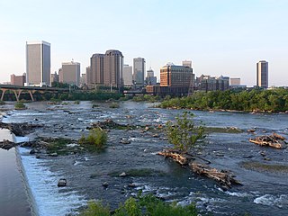
The Greater Richmond Region, the Richmond metropolitan area or Central Virginia, is a region and metropolitan area in the U.S. state of Virginia, centered on Richmond. The U.S. Office of Management and Budget (OMB) defines the area as the Richmond, VA Metropolitan Statistical Area, a Metropolitan Statistical Area (MSA) used by the U.S. Census Bureau and other entities. The OMB defines the area as comprising 17 county-level jurisdictions, including the independent cities of Richmond, Petersburg, Hopewell, and Colonial Heights. As of 2020, it had a population of 1,314,434, making it the 44th largest MSA in the country.
Tecate is a city in Tecate Municipality, Baja California. It is across the Mexico–US border from Tecate, California. As of 2019, the city had a population of 108,860 inhabitants, while the metropolitan area has a population of 132,406 inhabitants. Tecate is part of the San Diego-Tijuana metropolitan area and the largest city between Tijuana and Mexicali. Tecate is a regional economic hub and popular tourist destination, known as home to the Tecate Port of Entry and to Tecate Beer.
Torreón International Airport or Torreón/Gómez Palacio International Airport (Spanish: Aeropuerto Internacional de Torreón); officially Aeropuerto Internacional De Torreón Francisco Sarabia(Francisco Sarabia International Airport) (IATA: TRC, ICAO: MMTC), is an international airport located in Torreón, Coahuila, Mexico. It handles the national and international air traffic of the La Laguna Metropolitan Area, which includes Torreón, Coahuila, and the cities of Gómez Palacio and Lerdo in Durango.
León/Bajio International Airport ; officially Aeropuerto Internacional de Guanajuato, is an international airport situated in Silao, Guanajuato, Mexico. It is the main international airport serving the Greater León Metropolitan Area and the State of Guanajuato, which is home to a population of 6 million residents, including the cities of Celaya, Guanajuato, Irapuato, Salamanca, and San Miguel de Allende. In addition to offering domestic flights within Mexico, it serves as a gateway for international travel, connecting Central Mexico to various destinations in the United States. It serves as a focus city for Volaris and supports flight training, cargo, logistics and general aviation activities.
Aguascalientes International Airport ; officially Aeropuerto Internacional Lic. Jesús Terán Peredo(Lic. Jesús Terán Peredo International Airport)(IATA: AGU, ICAO: MMAS) is an international airport located in Aguascalientes, Mexico. It serves both domestic and international air traffic for the Metropolitan area of Aguascalientes, which is the capital city of the State of Aguascalientes in Mexico. It also supports a variety of executive and general aviation activities.
Nuevo Laredo International Airport ; officially Aeropuerto Internacional Quetzalcóatl(Quetzalcóatl International Airport) is an international airport located in Nuevo Laredo, Tamaulipas, Mexico, near the U.S.-Mexico border. It serves domestic flights within Mexico for the Laredo-Nuevo Laredo binational metropolitan area, the northern Tamaulipas and Nuevo León region and Southern Texas. It also supports various cargo operations, as well as executive and general aviation activities.
Puebla International Airport ; officially Aeropuerto Internacional Hermanos Serdán(Hermanos Serdán International Airport) is an international airport located in Huejotzingo, Puebla, Mexico. It handles national and international air traffic for the Metropolitan area of Puebla, the fourth-largest metro area in Mexico. It also supports cargo services and various executive and general aviation activities.
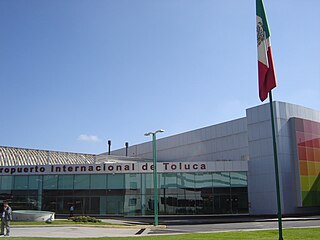
Toluca International Airport ; officially Aeropuerto Internacional Licenciado Adolfo López Mateos(Licenciado Adolfo López Mateos International Airport) is an international airport in Toluca, State of Mexico, Mexico. It handles both national and international air traffic for the Metropolitan area of Toluca and serves as a secondary airport for Greater Mexico City, alongside Felipe Angeles Airport. Historically serving as a hub for Volaris, Interjet, and Republicair, the airport is operated by Administradora Mexiquense del Aeropuerto Internacional de Toluca and is named after President Adolfo López Mateos.
Cuernavaca International Airport (Spanish: Aeropuerto Internacional de Cuernavaca); officially Aeropuerto Internacional General Mariano Matamoros(General Mariano Matamoros International Airport) (IATA: CVJ, ICAO: MMCB) is an airport located in Temixco, Morelos, Mexico. It manages air traffic for the Metropolitan area of Cuernavaca and the entire state of Morelos. Currently, the airport does not operate scheduled passenger public services. Travelers to and from Cuernavaca commonly use Mexico City International Airport, situated approximately 60 kilometres (37 mi) to the north of Cuernavaca.
Area code 505 is a telephone area code in the North American Numbering Plan (NANP) for the U.S. state of New Mexico. Its numbering plan area (NPA) comprises the northwestern and central portions of the state, including the Albuquerque metropolitan area, Gallup, Santa Fe, and Farmington. The area code is one of the original North American area codes established in October 1947. Until October 7, 2007, it served the entire state.
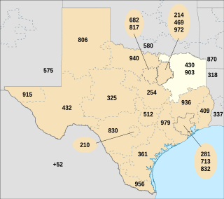
Area codes 903 and 430 are telephone area codes in the North American Numbering Plan (NANP) for the northeastern part of the U.S. state of Texas, including Texarkana, Tyler, and Sherman. The numbering plan area begins just north and east of the Dallas–Fort Worth metroplex, and extends to the Oklahoma, Arkansas, and Louisiana state borders. Area code 903 was created November 4, 1990 in a split of area code 214. Area code 430 was assigned to the same service area on February 15, 2003 in creation of an overlay. Before October 18, 1980, area code 903 was assigned to an area in northwestern Mexico.
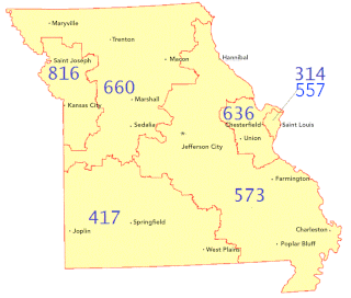
Area codes 573 and 235 are telephone area codes in the North American Numbering Plan (NANP) for most of the eastern half of the U.S. state of Missouri outside the immediate St. Louis area, including the state capital of Jefferson City, as well as Columbia, Cape Girardeau, Hannibal, Rolla, and Sikeston. The largest cities are Columbia, home to the University of Missouri, and Jefferson City, the state capital.The numbering plan area (NPA) extends across half of the width of the state, with the northeastern tip near the northeastern corner of the state, the Lake of the Ozarks at the western tip and Doniphan as the southwestern tip. They also serves all of southeastern Missouri and areas adjacent to the Mississippi River. 573 was created on January 7, 1996, in a split of area code 314, which was limited to the St. Louis metropolitan area in Missouri, and 235 was added on March 24, 2024 as part of an overlay complex.
Area code 580 serves most of southern and western Oklahoma, including Ada, Boise City, Lawton, Enid, Fairview, Ponca City, Altus, Frederick, Weatherford, Guymon, Durant, and Ardmore.
San Diego–Tijuana is an international transborder agglomeration, straddling the border of the adjacent North American coastal cities of San Diego, California, United States, and Tijuana, Baja California, Mexico. The 2020 population of the region was 5,456,577, making it the largest bi-national conurbation shared between the United States and Mexico, and the second-largest shared between the US and another country. The conurbation consists of the San Diego metropolitan area, in the United States and the municipalities of Tijuana, Rosarito Beach (126,980), and Tecate (108,440) in Mexico. It is the third most populous region in the California–Baja California region, smaller only than the metropolitan areas of Greater Los Angeles and the San Francisco Bay Area.
Telephone numbers in Mexico are regulated by the Federal Telecommunications Institute, an independent government agency of Mexico. The agency published the Fundamental Technical Plan for Numbering on May 11, 2013. The plan establishes a uniform ten-digit telephone number format. It took effect on August 3, 2019.