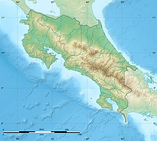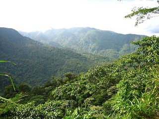
Costa Rica is located on the Central American Isthmus, surrounding the point 10° north of the equator and 84° west of the prime meridian. It has 212 km of Caribbean Sea coastline and 1,016 on the North Pacific Ocean.
La Selva Biological Station is a protected area encompassing 1,536 ha of low-land tropical rain forest in northeastern Costa Rica. It is owned and operated by the Organization for Tropical Studies, a consortium of universities and research institutions from the United States, Costa Rica, and Puerto Rico. Recognized internationally as one of the most productive field stations in the world for tropical forest research and peer-reviewed publications, La Selva hosts approximately 300 scientists and 100 university courses every year. The primary goal of La Selva Biological Station is to preserve and protect an intact forest, as well as providing laboratory facilities for tropical research and education. The research potential of the area is not only vital to tropical ecology, but it is also an important location in the effort to study relations between local communities and protected areas. In addition, its high diversity and ease of access to the Puerto Viejo-Horquetas highway makes La Selva an important ecotourism destination and environmental education center for tourists and the local community.

The wildlife of Costa Rica comprises all naturally occurring animals, fungi and plants that reside in this Central American country. Costa Rica supports an enormous variety of wildlife, due in large part to its geographic position between North and South America, its neotropical climate, and its wide variety of habitats. Costa Rica is home to more than 500,000 species, which represent nearly 5% of the species estimated worldwide, making Costa Rica one of the 20 countries with the highest biodiversity in the world. Of these 500,000 species, a little more than 300,000 are insects.

Corcovado National Park is a National Park on the Osa Peninsula, in Osa Canton, located on the southwestern regions of Costa Rica, which is a part of the Osa Conservation Area. Corcovado National Park was established in October 24 1975 and occupies an area of 424 square kilometres (164 sq mi). It is currently the largest park in Costa Rica and extends over about a third of the Osa Peninsula.

Braulio Carrillo National Park is a national park in Heredia Province, Cartago Province, Limón Province and San José Province, in central Costa Rica. It is part of the Central Conservation Area.

The Meghalaya subtropical forests is an ecoregion of Northeast India. The ecoregion covers an area of 41,700 square kilometers (16,100 sq mi), and despite its name, comprise not only the state of Meghalaya, but also parts of southern Assam, and a tiny bit of Nagaland around Dimapur and adjacent Bangladesh. It also contains many other habitats than subtropical forests, but the montane subtropical forests found in Meghalaya is an important biome, and was once much more widespread in the region, and for these reasons chosen as the most suitable name. The scientific designation is IM0126.

Arenal Volcano National Park is a Costa Rican national park in the central part of the country, part of the Arenal Huetar Norte Conservation Area. The park encompasses the Arenal Volcano, the most active in the country, which was believed to be dormant until a major eruption in 1968. It neighbors Lake Arenal, which is the site of the country's largest hydroelectricity project, the Lake Arenal Dam.

Yanachaga–Chemillén National Park is a protected area located in the region of Pasco, Peru. It preserves part of the rainforests and cloud forests of central Peru.

The Taita Hills, sometimes also spelled as Teita Hills, are a mountain range located in the Taita-Taveta County in south-eastern Kenya. The hills consist of three massifs: Dawida, Sagalla in the southern side of Voi township and Kasigau in the south near the border of Tanzania. The Dawida massif is the largest and tallest of the three, with an altitude of 2,228 metres (7,310 ft) above sea level at its highest peak, Vuria. Dawida has three other main peaks: Iyale, Wesu, and Susu.

The Sri Lanka montane rain forests is an ecoregion found above 1,000 m in the central highlands of Sri Lanka. Owing to their rich biodiversity, this region is considered to be a super-hotspot within endemic hotspots of global importance. These forests are cooler than lowland forests and therefore they have ideal conditions for growth of cloud forests. These forests classifications tropical sub montane forest, tropical sub-montane and tropical upper montane. Half of Sri Lanka's endemic flowering plants and 51 percent of the endemic vertebrates are restricted to these forests. More than 34 percent of Sri Lanka's endemic trees, shrubs, and herbs can only be found in this ecoregion. Twisted, stunted trees are a common sight in these forests, together with many varieties of orchids, mosses and ferns. The trees of montane rain forests grow to a height 10–15 meters, shorter than the lowland rain forest trees. These high altitude forests are the catchment area for most of Sri Lanka's major rivers.

The Serra do Divisor National Park is a 8,463 km2 (3,268 sq mi) national park on the westernmost point of Brazil, in the state of Acre, near the Peruvian border. It also has the highest point in that state, reaching 609 meters above sea level. It has been nominated by the Brazilian government as a Tentative World Heritage Site since 1998.

Zahamena National Park is a national park of Madagascar. Established in 1997, it covers an area of 423 square kilometres (163.32 sq mi) out of a total protected area of 643 square kilometres (248.26 sq mi). It is part of a UNESCO World Heritage Site, Rainforests of the Atsinanana, inscribed in 2007 and consisting of 13 specific areas located within eight national parks in the eastern part of Madagascar. In 2001, Bird Life International assessed avifauna of 112 species of which 67 species are exclusively endemic to Madagascar.

The Sri Lanka lowland rain forests represents Sri Lanka's Tropical rainforests below 1,000 m (3,281 ft) in elevation in the southwestern part of the island. The year-around warm, wet climate together with thousands years of isolation from mainland India have resulted in the evolution of numerous plants and animal species that can only be found in rain forests in Sri Lanka. The thick forest canopy is made up of over 150 species of trees, some of the emergent layer reaching as high as 45 m (148 ft). The lowland rain forests accounts for 2.14 percent of Sri Lanka's land area. This ecoregion is the home of the jungle shrew, a small endemic mammal of Sri Lanka. Sri Lanka has the highest density of amphibian species worldwide. Many of these, including 250 species of tree frogs, live in these rain forests.

The Isthmian–Atlantic moist forests (NT0129) are a Central American tropical moist broadleaf forest ecoregion located on the lowland slopes on the caribbean sea side of Nicaragua and Costa Rica and the Gulf and Pacific Ocean sides of Panama. The forest species are a mix of North American and South American, as this region only became a land bridge in the past 3 million years.

La Suerte Biological Field School, located in Northeastern Costa Rica, is one of two field schools operated by the Maderas Rainforest Conservancy. The site is situated in a tropical rainforest basin. It houses courses in primatology, ecology, botany, and other courses related to the flora and fauna of Northeastern Costa Rica.

Tortuguero National Park is a national park in the Limón Province of Costa Rica. It is situated within the Tortuguero Conservation Area of the northeastern part of the country. Despite its remote location, reachable only by airplane or boat, it is the third-most visited park in Costa Rica. The park has a large variety of biological diversity due to the existence within the reserve of eleven different habitats, including rainforest, mangrove forests, swamps, beaches, and lagoons. Located in a tropical climate, it is very humid, and receives up to 250 inches (6,400 mm) of rain a year.
Desarrollo Forestal Montreal S.A. is a nature reserve and cloud forest adjacent to Braulio Carrillo National Park in the central area of Costa Rica, about 30 miles (48 km) north of San José. The area is located between 1600–1800 meters (5,249–5,905 ft.) above sea level and extends throughout the mountain range.

The Kahuzi-Biega National Park is a protected area near Bukavu town in eastern Democratic Republic of the Congo. It is situated near the western bank of Lake Kivu and the Rwandan border. Established in 1970 by the Belgian photographer and conservationist Adrien Deschryver, the park is named after two dormant volcanoes, Mount Kahuzi and Mount Biega, which are within its limits. With an area of 6,000 square kilometres (2,300 sq mi), Kahuzi-Biega is one of the biggest national parks in the country. Set in both mountainous and lowland terrain, it is one of the last refuges of the rare species of Eastern lowland gorilla, an endangered category under the IUCN Red List. The park is a UNESCO World Heritage Site, inscribed in 1980 for its unique biodiversity of rainforest habitat and its eastern lowland gorillas. In 1997, it was listed on the List of World Heritage in Danger because of the political instability of the region, an influx of refugees, and increasing wildlife exploitation.
Timpoong and Hibok-Hibok Natural Monument is a Philippine natural monument located in Northern Mindanao on the island of Camiguin. It encompasses two scenic volcanoes in the Camiguin Mindanao range that span the core of Camiguin: Mount Mambajao, which includes Mount Timpoong, its highest peak, and Mount Catarman, which includes Mount Hibok-Hibok, the island's only currently active volcano. Established in 2004 through Proclamation No. 570 issued by President Gloria Arroyo, the natural monument is an important watershed containing the only remaining rainforest on Camiguin. It supports a variety of endemic flora and fauna and is also noted for its waterfalls, rivers and springs.

The Isthmian–Pacific moist forests ecoregion covers the lowland tropical evergreen forests on the Pacific side of the central mountains of southern Costa Rica and western Panama. As the meeting zone between North and South American floral communities, the area is one of very high biodiversity. Much of the rainforest has, however, been cleared for subsistence agriculture and cattle grazing.


