
Until 1974, Merionethshire or Merioneth was an administrative county in the north-west of Wales, later classed as one of the thirteen historic counties of Wales.

The Rhinogydd are a range of mountains located east of Harlech in North Wales. The name Rhinogydd derives from the names of two of the more famous peaks, Rhinog Fawr and Rhinog Fach, although the greatest elevation in the range is reached by Y Llethr, 756 m.

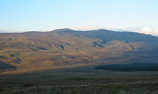
Arenig Fawr is a mountain in Snowdonia, North Wales, close to Llyn Celyn reservoir, alongside the A4212 between Trawsfynydd and Bala.

The Migneint is a large expanse of moorland in central Snowdonia, north-west Wales. It is part of the Migneint-Arenig-Dduallt Special Area of Conservation, along with the mountains Arenig Fawr, Arenig Fach and Dduallt, covering a range of nearly 200 square kilometres (77 sq mi). It is either the largest area of blanket bog in Wales, or the second largest, after the Berwyn range, further to the east.

Corn Du is a summit of the twin topped Pen y Fan and the second highest peak in South Wales at 871.5 m (2,864 ft), situated in the Brecon Beacons National Park. The summit itself is marked by a well structured Bronze Age cairn with a central burial cist like that on nearby Pen y Fan. The two summits are visible from great distances owing to their height above the surrounding moorland, and are famous landmarks. The views from the peaks are also panoramic and very extensive, the Black Mountain and Fforest Fawr being especially obvious to the west. Mynydd Epynt is visible to the north behind the county town of Brecon, and other parts of the escarpment to the east.

Aran Benllyn is a subsidiary summit of Aran Fawddwy in southern Snowdonia, North Wales, Wales, United Kingdom. It is the second highest peak in the Aran mountain range.

Gau Graig is a subsidiary summit of Cadair Idris in the Snowdonia National Park, in Gwynedd, northwest Wales. It lies to the east of Mynydd Moel on a broad grassy plateau. It marks the eastern end of the Cadair Idris ridge.

Carnedd y Filiast is a mountain near Cerrigydrudion on the border of the Snowdonia National Park, North Wales and is 669 metres (2,195 ft) high.

Arenig Fach is a mountain in southern Snowdonia, north Wales. It is a peak in the Arenig range and lies to the north of its parent peak Arenig Fawr.

Moel Llyfnant is a mountain in the southern portion of the Snowdonia National Park in Gwynedd, Wales. It is a peak in the Arenig mountain range. It lies to the west of Arenig Fawr. It has one notable top, the twin peaked Gallt y Daren, being at the end of its west ridge.
Gallt y Daren is a peak in the southern half of the Snowdonia National Park in Gwynedd, North Wales, and forms part of the Arenig mountain range. It is a top of Moel Llyfnant, and is twin peaked. It lies to the west of Moel Llyfnant.

Moelwyn Mawr North Ridge Top is a top of Moelwyn Mawr in Snowdonia, North Wales and forms part of the Moelwynion. From its summit, which directly overlooks Bwlch Rhosydd, can be seen Cnicht, Allt-fawr and Moel-yr-hydd. A recently discovered 'top' has only received attention from Nuttall baggers.

Carnedd Llechwedd-llyfn is a subsidiary summit of Carnedd y Filiast on the border of Snowdonia National Park in Llandderfel, in Gwynedd. The northern slopes of the peak lie in Ysbyty Ifan, in Conwy. It is part of the Arenig mountain range, and rises from the shore of Llyn Celyn.

Waun Garnedd-y-filiast is a top of Carnedd y Filiast on the border of the Snowdonia National park near Cerrigydrudion in North Wales. It is part of the Arenig mountain range. It is also a peak in an area of moorland known as the Migneint.

Arenig Fawr South Ridge Top is a top of Arenig Fawr in southern Snowdonia, North Wales. It lies in area of rocky knolls and small tarns, found on the broad south ridge of Arenig Fawr.
Foel Boeth is the twin top of Gallt y Daren in the southern half of the Snowdonia National Park in Gwynedd, North Wales, and forms part of the Arenig mountain range. Its parent peak is Moel Llyfnant.

Pen Twyn Mawr is a top of Pen y Gadair Fawr in the Black Mountains in south-eastern Wales. It lies on one of the many south ridges of Waun Fach.

Y Gamallt is a mountain located in the Migneint in Snowdonia, North Wales. It forms part of the Arenig mountain range being separated from the Moelwynion range at the head of Cwm Teigl.
The Afon Llafar is a small river in North Wales which, rising on the eastern slopes of Arenig Fawr, flows south-east through the hamlet of Parc and into Bala Lake. It is within the Dee catchment.

Mynydd Nodol is a 539m high hill in Snowdonia National Park and lying within the community of Llanycil in the county of Gwynedd in North Wales. It rises above the southern shores of the reservoir Llyn Celyn about 4 km northeast of its higher neighbour Arenig Fawr. Mynydd Nodol forms the backdrop in views from the A4212 car park by the dam. The hill throws down a broad shoulder to the east.
