The Don Valley Parkway (DVP) is a municipal expressway in Toronto, Ontario, Canada, which connects the Gardiner Expressway in downtown Toronto with Highway 401. North of Highway 401, it continues as Highway 404. The parkway runs through the parklands of the Don River valley, after which it is named. It has a maximum speed limit of 90 km/h (56 mph) for its entire length of 15.0 km (9.3 mi). It is six lanes for most of its length, with eight lanes north of York Mills Road and four lanes south of Eastern Avenue. As a municipal road, it is patrolled by the Toronto Police Service.

The Kansas Turnpike is a 236-mile (380 km) controlled-access toll road that lies entirely within the US state of Kansas. It runs in a general southwest–northeast direction from the Oklahoma border to Kansas City. It passes through several major Kansas cities, including Wichita, Topeka, and Lawrence. The turnpike is owned and maintained by the Kansas Turnpike Authority (KTA), which is headquartered in Wichita.

Interstate 676 (I-676) is an Interstate Highway that serves as a major thoroughfare through Center City Philadelphia, where it is known as the Vine Street Expressway, and Camden, New Jersey, where it is known as the northern segment of the North–South Freeway, as well as the Martin Luther King Jr. Memorial Highway in honor of civil rights leader Martin Luther King Jr. Its western terminus is at I-76 in Philadelphia near the Philadelphia Museum of Art and Fairmount Park. From there, it heads east and is then routed on surface streets near Franklin Square and Independence National Historical Park, home of the Liberty Bell, before crossing the Delaware River on the Benjamin Franklin Bridge. On the New Jersey side of the bridge, the highway heads south to its southern terminus at I-76 in Gloucester City near the Walt Whitman Bridge. Between the western terminus and downtown Camden, I-676 is concurrent with U.S. Route 30 (US 30).

Lake Shore Boulevard is a major arterial road running along more than half of the Lake Ontario waterfront in the city of Toronto, Ontario, Canada. Prior to 1998, two segments of Lake Shore Boulevard were designated as part of Highway 2, with the highway following the Gardiner Expressway between these two sections.

Franklin D. Roosevelt East River Drive, commonly known as the FDR Drive, is a controlled-access parkway on the east side of the New York City borough of Manhattan. It starts near South and Broad Streets, just north of the Battery Park Underpass, and runs north along the East River to the 125th Street / Robert F. Kennedy Bridge interchange, where it becomes Harlem River Drive. All of FDR Drive is designated New York State Route 907L (NY 907L), an unsigned reference route.

Interstate 635 (I-635) is a connector highway between I-35 in Overland Park, Kansas, and I-29 in Kansas City, Missouri, Not to be Confused with Interstate 635 in texas approximately 12 miles (19 km) long. It is mostly in the US state of Kansas, servicing the city of Kansas City, Kansas, but extends into Kansas City, Missouri, as well. The freeway's southern terminus is at a stack interchange with I-35. South of this, the mainline becomes an expressway carrying U.S. Route 69 (US 69).

Forgottonia, also spelled Forgotonia, is the name given to a 16-county region in Western Illinois in the late 1960s and early 1970s. This geographic region forms the distinctive western bulge of Illinois that is roughly equivalent to "The Tract", the Illinois portion of the Military Tract of 1812, along and west of the Fourth Principal Meridian. Since this wedge-shaped region lies between the Illinois and Mississippi rivers, it has historically been isolated from the eastern portion of Central Illinois.
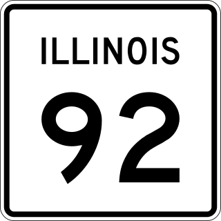
Illinois Route 92 is an east–west state highway in northwest Illinois. It runs from the Norbert F. Beckey Bridge across the Mississippi River where it meets the eastern end of Iowa Highway 92, east to U.S. Route 34 in La Moille. This is a distance of 106.41 miles (171.25 km). It is part of a continuous 886-mile (1,426 km) four-state "Highway 92" which begins in Torrington, Wyoming, goes through Nebraska and Iowa and before terminating in Illinois.
The 18th Street Expressway is a freeway in Kansas City, Kansas that runs from Interstate 35 north to Interstate 70/U.S. Route 24/U.S. Route 40. It carries the U.S. Route 69 designation its entire length.

U.S. Route 50 (US 50) is a part of the U.S. Highway System that travels from West Sacramento, California, to Ocean City, Maryland. In the U.S. state of Colorado, US 50 is a major highway crossing through the lower midsection of the state. It connects the Western Slope with the lower Front Range. The highway serves the areas of Pueblo and Grand Junction as well as many other smaller areas along its corridor. The long-term project to widen the highway from two lanes to a four lane expressway between Grand Junction and Montrose was completed in January 2005. Only about 25% of the remainder of highway 50 in Colorado is four lane highway.

U.S. Highway 169 (U.S. 169) is a major north–south highway in the U.S. state of Minnesota, connecting the Minnesota River valley with the Twin Cities and the Iron Range. Much of the route is built to expressway or freeway standards.
The 18th Street Expressway Bridge is a one level deck truss, four lane crossing of the Kansas River in Kansas City, Kansas. It was built in 1959, to replace the Argentine Bridge to the west.
The 12th Street Bridge is an automobile crossing of the Kansas River in Kansas City, Kansas.
The Kansas Avenue Bridge (West) is a four lane, multi-beam girder bridge crossing the Kansas River, and a small company on the east side. It was first built in 1916 as a 9 span thru-truss, but later in 1988 destroyed, and replaced with the current multi-beam girder bridge. It is just west of the 18th Street Expressway Bridge.
The Oakland Expressway Bridge is an automobile crossing of the Kansas River at Topeka, Kansas. It is open to traffic, and also carries K-4 as well. The bridge used drilled shaft construction technology when built in 1996.
Armourdale community is a district in the lower part of the Kansas River valley in Kansas City, Kansas. It is a main district between the West Bottoms and the Rosedale, Kansas area. The Kansas River makes an oxbow curve around the entire district, which is home to Shawnee Park and Bill Clem Park.

K-58 is a 46.761-mile-long (75.255 km) east–west–west state highway in the U.S. state of Kansas. K-58's western terminus is at K-99 west of Madison. It runs east through Lamont and Gridley and after a short concurrency with US-75, it goes through LeRoy before ending at the eastern terminus at U.S. Route 169 (US-169) near Colony. It is one of the newer state highways in Kansas formed on September 20, 2004, when K-57 was truncated at K-4 in Dwight. The route changes were made because of K-57's long concurrencies with K-4, K-177, US-50 and K-99.

U.S. Route 69 (US-69) is a major north-south U.S. Highway that runs from Port Arthur, Texas to Albert Lea, Minnesota. In Kansas, the highway runs in the far eastern part of the state, usually within five miles of the Missouri state line. Most of the highway north of Fort Scott runs as a freeway.

Milford Lake, also known as Milford Reservoir, is the largest man-made lake in Kansas with 15,700 acres (64 km2) of water. Over 33,000 acres (130 km2) of land resources are managed for quality recreational experiences as well as for protection of the project’s natural and cultural resources. Approximately 70% of the land resources are available for public hunting.
Clements is an unincorporated community in Chase County, Kansas, United States. It is located about halfway between Strong City and Florence near the intersection of U.S. Route 50 highway and G Rd.
