
Antananarivo, also known by its colonial shorthand form Tana, is the capital and largest city of Madagascar. The administrative area of the city, known as Antananarivo-Renivohitra, is the capital of Analamanga region. The city sits at 1,280 m (4,199 ft) above sea level in the center of the island, the highest national capital by elevation among the island countries. It has been the country's largest population center since at least the 18th century. The presidency, National Assembly, Senate and Supreme Court are located there, as are 21 diplomatic missions and the headquarters of many national and international businesses and NGOs. It has more universities, nightclubs, art venues, and medical services than any city on the island. Several national and local sports teams, including the championship-winning national rugby team, the Makis are based here.
Antananarivo Province is a former province of Madagascar with an area of 58,283 square kilometres (22,503 sq mi). It had a population of 5,370,900 in 2004. Its capital was Antananarivo, which is also the capital of the country. Established in 1965, it was the most important province of Madagascar in terms of industrial production. It was one of the most literate provinces and was dominated by the Merina people. Along with the other five provinces, it was abolished in 2007 after a referendum in favour of creation of smaller regions to help in development was approved. It was badly affected by plagues in the 20th century. In 2002 a state of emergency was proclaimed by the then president Didier Ratsiraka. The events that followed led to the other five provinces announcing the creation of a new republic that would have excluded Antananarivo Province. Peace was restored only when Marc Ravalomanana was installed as the country's president.

Antsirabe is the third largest city in Madagascar and the capital of the Vakinankaratra region, with a population of 265,018 in 2014. In Madagascar, Antsirabe is known for its relatively cool climate, its industry and the high concentration of pulled rickshaws or pousse-pousse. It attracts around 30,000 tourists a year

Anjozorobe is a large town in the Analamanga Region, Madagascar, approximately 90 kilometers north-east of the capital Antananarivo. It has a population of 24,117 inhabitants in 2018.

Soavina is a rural commune in Analamanga Region, in the Central Highlands of Madagascar. It belongs to the district of Antananarivo-Atsimondrano and its populations numbers to 15,658 in 2018.
Vakinankaratra is a region in central Madagascar. The capital of the region is Antsirabe. Vakinankaratra covers an area of 16,599 kilometres, and had a population of 2,074,358 in 2018.
Ankaratra is a cinder cone volcano range located about 50 km (30 mi) southwest of Antananarivo, the capital city of Madagascar. It lies between the towns of Arivonimamo to the North, Ambatolampy to the East, Faratsiho to the West and Betafo to the South. It is located in the Central Highlands. The highest peak in Ankaratra is Tsiafajavona, at 2,644 metres (8,668 ft.) above sea level. Some trace of activity remains in the southernmost part of the range, creating hot springs in the area around Antsirabe. The last eruption of Ankaratra took place in the very recent Quaternary.

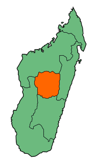
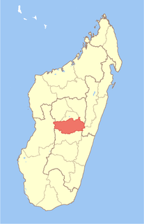
Analamanga is a region in central Madagascar, containing the capital Antananarivo and its surrounding metropolitan area. The region has an area of 16,911 square kilometres, and had a population of 3,618,128 in 2018.

Alaotra-Mangoro is a region in eastern Madagascar. It borders Sofia Region in north, Analanjirofo in northeast, Atsinanana in east, Vakinankaratra in southwest, Analamanga in west and Betsiboka in northwest. The capital of the region is Ambatondrazaka, and the population was 1,255,514 in 2018. The area of the region is 31,948 km2 (12,335 sq mi).

Itasy is a region in central Madagascar. It borders Analamanga region in northeast, Vakinankaratra in south and Bongolava in northwest. The capital of the region is Miarinarivo, and the population was 897,962 in 2018. It is the smallest of all the 22 regions in area with 6,993 km2 (2,700 sq mi), and is the most densely populated region after Analamanga.

Alkamisikely is a town and commune in Madagascar. It belongs to the district of Arivonimamo District which is a part of Itasy Region. The population of the commune was 3,957 in 2019.

Amboanana is a town and commune in Madagascar. It belongs to the district of Arivonimamo, which is a part of Itasy Region. The population of the commune was estimated 19,217 in 2019.
Ambohimandry is a town and commune in Madagascar. It belongs to the district of Arivonimamo, which is a part of Itasy Region in Antananarivo Province. The population of the commune was estimated to be approximately 24,000 in 2001 commune census.
Imerintsiatosika is a municipality in Madagascar. It belongs to the district of Arivonimamo, which is a part of Itasy Region. It is localized at 30 km west from the capital of Antananarivo on the National Road No.1. The population of the commune was estimated to be 69,953 in a 2019.
Arivonimamo Air Base, or simply Antananarivo Arivonimamo Air Base, is a military airport located in Arivonimamo, Madagascar.
Alarobia Vatosola is a rural commune in Analamanga Region, in the Central Highlands of Madagascar in the district of Andramasina. It is located at 70 km south-east of Antananarivo. It counts a population of 14,777 in 2018.
Masindray is a rural commune in Analamanga Region, in the Central Highlands of Madagascar. It belongs to the district of Antananarivo Avaradrano and its populations numbers to 13,505 in 2018. It is situated at 20 km West from Antananarivo.
Ampahitrosy is a suburb and a rural commune in Analamanga Region, in the Central Highlands of Madagascar. It belongs to the district of Antananarivo-Atsimondrano and its populations numbers to 5,654 in 2018.
Sabotsy Manjakavahoaka is a rural municipality in Analamanga Region, in the Central Highlands of Madagascar. It belongs to the district of Andramasina and its populations numbers to 9,658 in 2019.

