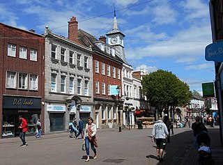
Nuneaton is a market town in the borough of Nuneaton and Bedworth in northern Warwickshire, England, located adjacent to the county border with Leicestershire to the north-east. Nuneaton's population at the 2021 census was 94,634, an increase from 86,552 at the 2011 census making it the largest town in Warwickshire.

Cinderford is a town and civil parish on the eastern fringe of the Forest of Dean in Gloucestershire, England. The population was 8,777 at the 2021 Census.

North Warwickshire is a local government district with borough status in the ceremonial county of Warwickshire, West Midlands, England. The borough includes the two towns of Atherstone and Coleshill, and the large villages of Polesworth, Kingsbury, Hartshill and Water Orton.

Dukinfield is a town in Tameside, Greater Manchester, England, on the south bank of the River Tame opposite Ashton-under-Lyne, 6.3 miles (10.1 km) east of Manchester. At the 2011 Census, it had a population of 19,306.

Brierfield is a town and civil parish in the Borough of Pendle, in Lancashire, England. It is 3 miles (4.8 km) north east of Burnley, 1 mile (1.6 km) south west of Nelson, and 1 mile (1.6 km) north east of Reedley. The parish had a population of 8,193, at the census of 2011.
Kingsbury is a large village and civil parish in the North Warwickshire district of the county of Warwickshire, in the West Midlands region of England. The civil parish population at the 2011 census was 7,652.
Atherton is a town in the Metropolitan Borough of Wigan in Greater Manchester, England and historically part of Lancashire. The town, including Hindsford, Howe Bridge and Hag Fold, is 5 miles (8.0 km) south of Bolton, 7 miles (11.3 km) east of Wigan, and 10 miles (16.1 km) northwest of Manchester. From the 17th century, for about 300 years, Atherton was known as Chowbent, which was frequently shortened to Bent, the town's old nickname. During the Industrial Revolution, the town was a key part of the Manchester Coalfield.
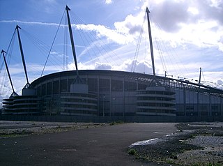
Bradford is a district of east Manchester, England, two miles north east of the city centre. The population at the 2011 census was 15,784. Historically in Lancashire, after the closure of its heavy industries Bradford was for many years an economically deprived area but has undergone regeneration with the building of the City of Manchester Stadium which hosted the 2002 Commonwealth Games and is now home to Manchester City F.C. Bradford is neighboured by Beswick to the south and the two areas are sometimes referred to as Bradford-with-Beswick. The River Medlock and the Ashton Canal run through Bradford.

Ansley is a village and civil parish in the North Warwickshire district of Warwickshire, England. The parish includes the village of Ansley, Ansley Common, Church End, Ansley Hall, Birchley Heath, and formerly Ansley Hall Colliery. The village is near Arley and Astley. The parish church of St Lawrence is Norman in origin and lies outside the main village at Church End. It is a Grade II* listed building. The church includes stained glass by Karl Parsons. Ansley Hall dates from the early eighteenth century. It was taken over by the Ansley Hall Coal and Iron Company, founded by William Garside Phillips, the great grandfather of Captain Mark Phillips.

Kearsley is a town in the Metropolitan Borough of Bolton, Greater Manchester, England. The population at the 2011 census was 14,212. Within the Historic County of Lancashire, it lies 8 miles (13 km) northwest of Manchester, 5 miles (8 km) southwest of Bury and 3+3⁄4 miles (6 km) south of Bolton.
Hurley is a village in the Kingsbury civil parish of North Warwickshire, England. Other nearby places include Wood End, Hurley Common, Coleshill, Water Orton, Curdworth, Atherstone and Tamworth. According to the 2001 Census the population of the Hurley and Wood End ward was 3,642. Over 99.5% of people (3,550) described themselves as White British with only 92 people from other ethnic groups. The most common distance travelled to work is 5–10 kilometres (3.1–6.2 mi), which is essentially to Tamworth, with the most common form of employment being manufacturing. The village has an almost exact 50:50 split of males and females, with a ratio of 1,822 to 1,820 respectively.

Old Arley is a village in the civil parish of Arley, in the north of Warwickshire, England, 5.5 miles (8.9 km) west of Nuneaton and 10 miles (16 km) north west of the city of Coventry.
The Roman Catholic parish of St Anne, Nuneaton, in Warwickshire, England, serves the western side of Nuneaton and outlying villages towards Coleshill. The parish is part of the Roman Catholic Archdiocese of Birmingham and a part of the Rugby Deanery. The current Parish Priest is Fr. George.
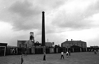
Kingsbury Colliery was a coal mine in Kingsbury, Warwickshire, which operated between 1897 and 1968.

Daw Mill was a coal mine located near the village of Arley, near Nuneaton, in the English county of Warwickshire. The mine was Britain's biggest coal producer. It closed in 2013 following a major fire. It was the last remaining colliery in the West Midlands.
Hindsford is a suburb of Atherton in the Metropolitan Borough of Wigan, Greater Manchester, England. It is situated to the west of the Hindsford Brook, an ancient boundary between the townships of Atherton and Tyldesley cum Shakerley, and east of the Chanters Brook in the ancient parish of Leigh.
Fletcher, Burrows and Company was a coal mining company that owned collieries and cotton mills in Atherton, Greater Manchester, England. Gibfield, Howe Bridge and Chanters collieries exploited the coal mines (seams) of the middle coal measures in the Manchester Coalfield. The Fletchers built company housing at Hindsford and a model village at Howe Bridge which included pithead baths and a social club for its workers. The company became part of Manchester Collieries in 1929. The collieries were nationalised in 1947 becoming part of the National Coal Board.
The Warwickshire Coalfield extends between Warwick and Tamworth in the English Midlands. It is about 25 miles (40 km) from north to south and its width is around half that distance. Its western margin is defined by the 'Western Boundary Fault'. In the northeast it abuts against steeply dipping shales of Cambrian age. The larger part of the outcrop at the surface consists of the Warwickshire Group of largely coal-barren red beds. Until its closure in 2013, the Daw Mill mine near Arley within the coalfield, was Britain's biggest coal-producer in the 21st century.
Parsonage Colliery was a coal mine operating on the Lancashire Coalfield in Leigh, then in the historic county of Lancashire, England. The colliery, close to the centre of Leigh and the Bolton and Leigh Railway was sunk between 1913 and 1920 by the Wigan Coal and Iron Company and the first coal was wound to the surface in 1921. For many years its shafts to the Arley mine were the deepest in the country. The pit was close to the town centre and large pillars of coal were left under the parish church and the town's large cotton mills.
