
Tamil Nadu is a state in southern India. Its capital and largest city is Chennai. The state is the home of the Tamil people, whose Tamil language—one of the longest surviving classical languages in the world—is widely spoken in the state and serves as its official language.

Madurai is one of the longest living cities in the world and a major city in the Indian state of Tamil Nadu. It is the cultural capital of Tamil Nadu and the administrative headquarters of Madurai District. As of the 2011 census, it was the third largest Urban agglomeration in Tamil Nadu after Chennai and Coimbatore and the 44th most populated city in India. Located on the banks of River Vaigai, Madurai has been a major settlement for two millennia and has a documented history of more than 2500 years. It is often referred to as "Thoonga Nagaram", meaning "the city that never sleeps".

Nagapattinam is a town in the Indian state of Tamil Nadu and the administrative headquarters of Nagapattinam District. The town came to prominence during the period of Medieval Cholas and served as their important port for commerce and east-bound naval expeditions. The Chudamani Vihara in Nagapattinam constructed by the Srivijayan king Sri Mara Vijayattungavarman of the Sailendra dynasty with the help of Rajaraja Chola I was an important Buddhist structure in those times. Nagapattinam was settled by the Portuguese and, later, the Dutch under whom it served as the capital of Dutch Coromandel from 1660 to 1781. In November 1781, the town was conquered by the British East India Company. It served as the capital of Tanjore district from 1799 to 1845 under Madras Presidency of the British. It continued to be a part of Thanjavur district in Independent India. In 1991, it was made the headquarters of the newly created Nagapattinam District. Nagapattinam is administered by a Special grade municipality covering an area of 17.92 km2 (6.92 sq mi) and had a population of 102,905 as of 2011.

Chennai district, formerly known as Madras district, is one of the 38 districts in the state of Tamil Nadu, India. It is the smallest and the most densely populated district in the state. The district is coterminous with the city of Chennai, which is administered by the Greater Chennai Corporation. It is surrounded by Tiruvallur district in the north and the west, Kanchipuram district in the south-west, Chenglpattu district in the south, and the Bay of Bengal in the east.

Vellore district is one of the 38 districts in the Tamil Nadu state of India. It is one of the eleven districts that form the north region of Tamil Nadu. Vellore city is the headquarters of this district. As of 2011, the district had a population of 1,614,242 with a sex ratio of 1,007 females for every 1,000 males. In 2017 Vellore district ranked eleventh in list of districts in Tamil Nadu by Human Development Index.

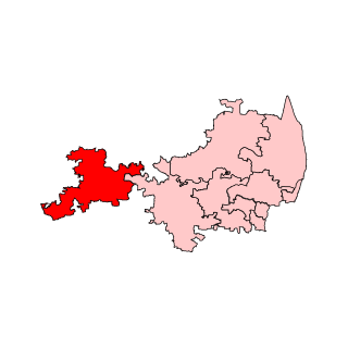
Nagapattinam district is one of the 38 districts of Tamil Nadu state in southern India. Nagapattinam district was carved out by bifurcating the erstwhile composite Thanjavur district on 19 October 1991. The town of Nagapattinam is the district headquarters. As of 2011, the district had a population of 697,069 with a sex-ratio of 1,025 females for every 1,000 males. Until Mayiladuthurai district was created out of it on 24 March 2020, Nagapattinam was the only discontiguous district in Tamil Nadu.
Tindivanam is a town and a municipality in Viluppuram district in the Indian state of Tamil Nadu. It is the second largest town in Villupuram District after the headquarters town Villupuram. Important roads from north to south Tamil Nadu pass through Tindivanam and similarly from west to east.
Virudhachalam or Vriddhachalam is a Town and taluk headquarters in Cuddalore district in the Indian state of Tamil Nadu. The ancient name of this town is Thirumudhukundram. As per the 2011 census, the town had a population of 73,585 of which 37,066 are males while 36,519 are females. Population of children in the ages of 0-6 is 7735 which is 10.51 % of the total population. The old Lord Siva temple is located in the heart of town. This is the 41st Devaram Padal Petra Siva Thiruthalam and 9th Thiruthalam in Nadu Naadu(நடுனாடு). Moovar has sung hymns in praise of Lord Siva of this temple. The temple was constructed by one of the Chola Emperors. The famous Kolanjiappar Temple is located 3 km away from the town. Both of them are situated near Cuddalore - Salem highway in Virudhachalam.

Sirkazhi also spelled as Siyali is a major municipal town in Mayiladuthurai district in Tamil Nadu, India. It is located 13 km (8.1 mi) from the coast of the Bay of Bengal, and 250 km (160 mi) from the state capital Chennai. Sirkazhi was a part of Thanjavur district until 1991 and has later been part of Nagapattinam district. The town covers an area of 13.21 km2 (5.10 sq mi) and in 2011 had a population of 34,927. It is administered by a second grade municipality. Sirkazhi is part of the Cauvery delta region and agriculture is the major occupation. Roads are the main means of transportation; the town has 51.47 km (31.98 mi) of district roads, including a national highway.

At the 2011 Census of India, the population of the state of Tamil Nadu was 72,147,039, increasing from 62.4 million in 2001. There were 36,137,975 males and 36,009,064 females, with a sex ratio of 996 females per 1000 males. Its literacy rate was 80.09%. 10.51% of the population was below seven years old, and it had a population density of 555.

The Government of Tamil Nadu is the governing authority for the Indian state of Tamil Nadu. It is seated at Fort St George, Chennai. The legislature of Tamil Nadu was bicameral until 1986, when it was replaced by a unicameral legislature, like most other states in India.
Puthagaram is a village in Tamil Nadu, India. Here ancient Sri Maha kaliamman Temple is located.
Papanasam taluk is a taluk of Thanjavur district of the Indian state of Tamil Nadu. The headquarters of the taluk is the town of Papanasam.
Tiruttani is a state assembly constituency in Tiruvallur district in Tamil Nadu. It consists of Pallipattu taluk and a portion of Tiruttani taluk. It falls under Arakkonam. Elections and winners in the constituency are listed below.
Poondi is a village in the Thiruvallur taluk of Tiruvallur district, Tamil Nadu, India. It has a fresh water lake to cater the daily needs of water for Chennai City. The place is also known for Oondreswarar Temple, which was displaced to its current location to ease the construction of the reservoir.
Devanur is a village in the Andimadam taluk of Ariyalur district, Tamil Nadu, India.
Koollu is a village in the Hosur taluk of Krishnagiri district, Tamil Nadu, India.

Tiruvannamalai district is the largest and one of the 38 districts in the state of Tamil Nadu, in South India. It was formed in the year 1989 through the bifurcation of North Arcot into the Tiruvannamalai Sambuvarayar and Vellore Ambedkar districts. The city of Tiruvannamalai is the district headquarters.
Maaththoor formerly known as Mathur is a residential area located north of Chennai, a metropolitan city in Tamil Nadu, India. Maaththoor is administered by the Greater Chennai Corporation and belongs to Madhavaram taluk of Chennai district.
Sholinganallur taluk is a taluk of the city district of Chennai in the Indian state of Tamil Nadu. It was created in 2009 by the trifurcation of Tambaram taluk in Chennai district. The centre of the taluk is the neighbourhood of Sholinganallur. The headquarters of is Guindy division. On 4 January 2018, Chennai district was expanded by annexing Sholinganallur taluk.

