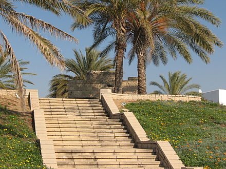
Caesarea Maritima, formerly Strato's Tower, also known as Caesarea Palestinae, was an ancient city in the Sharon Plain on the coast of the Mediterranean, now in ruins and included in an Israeli national park.

Ashdod is the sixth-largest city and the largest port in Israel accounting for 60% of the country's imported goods. Ashdod is located in the Southern District of the country, on the Mediterranean coast where it is situated between Tel Aviv to the north 32 kilometres away, and Ashkelon to the south 20 km (12 mi) away. Jerusalem is 53 km (33 mi) to the east. The city is also an important regional industrial center.
Hippos is an archaeological site in Israel, located on a hill overlooking the Sea of Galilee. Between the 3rd century BCE and the 7th century CE, Hippos was the site of a Greco-Roman city, which declined under Muslim rule and was abandoned after an earthquake in 749. Besides the fortified city itself, Hippos controlled two port facilities on the lake and an area of the surrounding countryside. Hippos was part of the Decapolis, or Ten Cities, a region in Roman Jordan, Syria and Israel that were culturally tied more closely to Greece and Rome than to the Semitic ethnoi around.

The archaeology of Israel is the study of the archaeology of the present-day Israel, stretching from prehistory through three millennia of documented history. The ancient Land of Israel was a geographical bridge between the political and cultural centers of Mesopotamia and Egypt. Despite the importance of the country to three major religions, serious archaeological research only began in the 15th century. The first major work on the antiquities of Israel was Adriaan Reland's Palestina ex monumentis veteribus, published in 1709. Edward Robinson, an American theologian who visited the country in 1838, published the first topographical studies. Lady Hester Stanhope performed the first modern excavation at Ashkelon in 1815. A Frenchman, Louis Felicien de Saucy, embarked on early "modern" excavations in 1850.

Madaba is the capital city of Madaba Governorate in central Jordan, with a population of about 60,000. It is best known for its Byzantine and Umayyad mosaics, especially a large Byzantine-era mosaic map of the Holy Land. Madaba is located 30 kilometres south-west of the capital Amman.

Afek is a kibbutz in northern Israel. Located in the Zevulun Valley in the Western Galilee, near the archaeological site of Tel Afek and the HaKerayot agglomeration, it falls under the jurisdiction of the Mateh Asher Regional Council. In 2018 it had a population of 684.

Gath or Gat, often referred to as Gath of the Philistines, was one of the five Philistine city-states, established in northeastern Philistia. Gath is often mentioned in the Hebrew Bible and its existence is confirmed by Egyptian inscriptions.

Tel Maresha is the tell of the biblical Iron Age city of Maresha, and of the subsequent, post-586 BCE Idumean city known by its Hellenised name Marisa, Arabised as Marissa (ماريسا). The tell is situated in Israel's Shephelah region, i.e. in the foothills of the Judaean Mountains. It was first excavated in 1898-1900 by the British archaeologists Bliss and Macalister on behalf of the Palestine Exploration Fund and again after 1989 by Israeli archaeologist Amos Kloner on behalf of the Israel Antiquities Authority. The majority of the artifacts of the British excavation are to be found today in the Istanbul Archaeology Museums.
Meṣad Hashavyahu is an ancient fortress on the border of ancient Judea facing the Philistine city of Ashdod near the Mediterranean Sea. It lies 1.7 km south of Yavne-Yam and 7 km northwest of Yavne. The original name of the fort is unknown, but was given the name found on several inscribed pottery shards (ostraca) recovered at the site. The site covers an area of approximately 1.5 acres (6,100 m2).
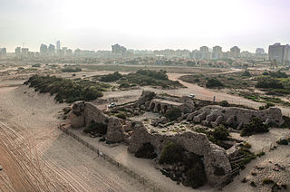
Minat al-Qal'a, sometimes wrongly named Qal'at al-Mina, is a medieval coastal fort protecting the port known as Ashdod-Yam, which was historically separate from Ashdod proper but whose archaeological remains are today located on the southern beach of the sprawling modern city of Ashdod. The fort has been built by the Umayyads and later restored and used again by the Crusaders.

Khirbet Kerak or Beth Yerah is a tell located on the southern shore of the Sea of Galilee in modern-day Israel. The tell spans an area of over 50 acres—one of the largest in the Levant—and contains remains dating from the Early Bronze Age and from the Persian period through to the Early Islamic period.
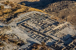
Khirbet Qeiyafa is the site of an ancient fortress city overlooking the Elah Valley and dated to the first half of the 10th century BCE. The ruins of the fortress were uncovered in 2007, near the Israeli city of Beit Shemesh, 30 km (20 mi) from Jerusalem. It covers nearly 2.5 ha and is encircled by a 700-meter-long (2,300 ft) city wall constructed of stones weighing up to eight tons each. Excavations at site continued in subsequent years. A number of archaeologists, mainly Yosef Garfinkel and Saar Ganor, have claimed that it might be the biblical city of Sha'arayim, because of the two gates discovered on the site, or Neta'im and that the large building at the center is an administrative building dating to the reign of King David, where he might have lodged at some point. This is based on their conclusions that the site dates to the early Iron IIA, ca. 1025–975 BCE, a range which includes the biblical date for the Kingdom of David. Others suggest it might represent either a North Israelite, Philistine or Canaanite fortress, a claim rejected by the archaeological team that excavated the site. The team's conclusion that Khirbet Qeiyafa was a fortress of King David has been criticised.

Yavne-Yam or Minet Rubin is an archaeological site located on Israel's southern Mediterranean coast, about 15 km south of Tel Aviv. Built on eolianite hills next to a small promontory forming the sole anchorage able to provide shelter to seagoing vessels between Jaffa and the Sinai, Yavne-Yam is notable for its role as the port of ancient Yavne. Excavations carried out by Tel Aviv University since 1992 have revealed continuous habitation from the second millennium BCE up to the Middle Ages; the famous Yavne-Yam ostracon is named after the site.

The Qal'at al-Bahrain, also known as the Bahrain Fort or Portuguese Fort, is an archaeological site located in Bahrain. Archaeological excavations carried out since 1954 have unearthed antiquities from an artificial mound of 12 m (39 ft) height containing seven stratified layers, created by various occupants from 2300 BC up to the 18th century, including Kassites, Greeks, Portuguese and Persians. It was once the capital of the Dilmun civilization and was inscribed as a UNESCO World Heritage Site in 2005.
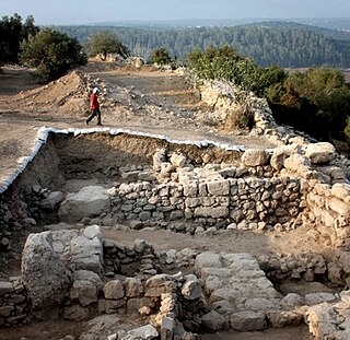
The ancient city walls around of the City of David refer to what archaeologist Eilat Mazar believes are the remains of the fortifications that once encompassed the city. The remains were re-excavated near a natural ridge to the north of the City of David in 2010 by Eilat Mazar, who believes them to date to the late 10th century BCE. They are located between areas commonly known as the Ophel to the north and the City of David to the south.

Tel Michal is an archaeological site on Israel's central Mediterranean coast, near the modern city of Herzliya, about 6.5 kilometres (4.0 mi) north of the Yarkon River estuary and 4 kilometres (2.5 mi) south of Arsuf-Appolonia. Excavations have yielded remains from the Middle Bronze Age to the Early Arab period.
The Paralia, also known as Medinat HaYam was a coastal eparchy in Palestine during Hellenistic and Roman times, ruled by the Seleucid Empire between 197 and 99 BCE, as part of the Coele-Syria province. According to Josephus, the inhabitants of the region were primarily Greek city-dwellers. The name appears in the 6th-century Madaba Map, appended to the town of Ashdod-Sea, as Azotos Paralos, ca. 3 kilometers south of Modern Ashdod.

Tel Yokneam, also spelled Yoqne'am or Jokneam, is an archaeological site located between the modern city of Yokneam Illit and the town of Yokneam Moshava. It was known in Arabic by a variant name, Tell Qamun, believed to be a corruption of the Hebrew name. The site is an elevated mound, or tel, spanning around 40 dunams and rising steeply to a height of 60 meters (200 ft). With a few brief interruptions, Yokneam was occupied for 4,000 years, from the Middle Bronze Age to the Ottoman Empire.